- Top
- Disaster
- 2010
- Observation of concentrated heavy rain in Pakistan by AVNIR-2 onboard "Daichi" (ALOS) (6)
Observation of concentrated heavy rain in Pakistan by AVNIR-2 onboard "Daichi" (ALOS) (6)
Northwestern Pakistan in the central Asia has been seriously damaged due to floods and mudslides caused by heavy rain which had occurred continuously since July 29, 2010. The Japan Aerospace Exploration Agency (JAXA) has performed the observation to monitor the state of the damage by the Advanced Visible and Near Infrared Radiometer type 2 (AVNIR-2)* onboard the Advanced Land Observing Satellite (ALOS, "Daichi") at 15:00 (JST) or 6:00 (UTC) on September 1, 2010 further to August 3, 5, 6, 15 and 23, 2010.
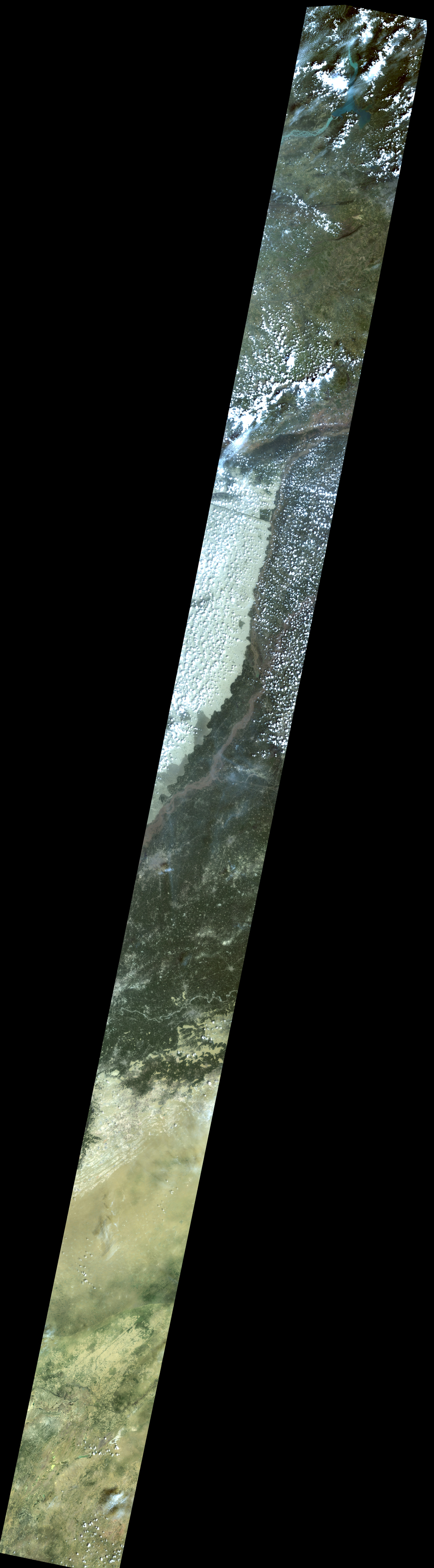
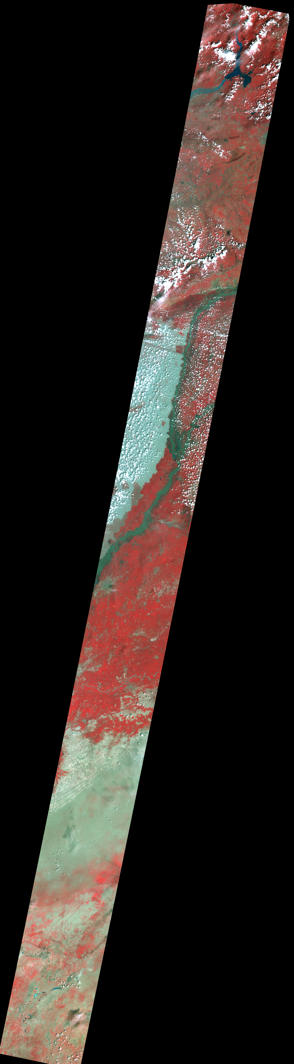
Fig. 1 shows an observed image and is assigned band 3, 2 and 1 of AVNIR-2 as the true color composite. White colored areas show clouds, swollen rivers and floods at agricultural land could be seen.
Enlarged Image
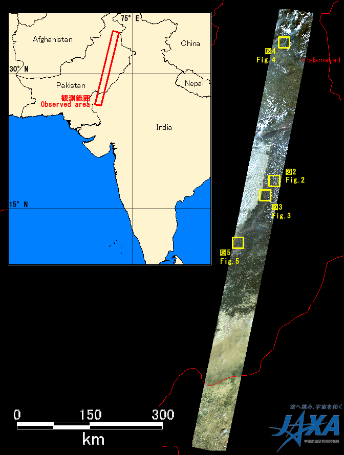
Fig.1: AVNIR-2 image with 0.0 degree pointing angle acquired at 15:00 on September 1, 2010 (JST).
Yellow squares show location of Figs. 2 to 5.
(Click to view enlarged image)
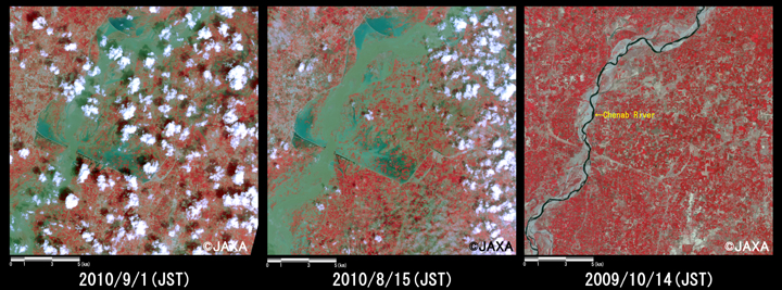
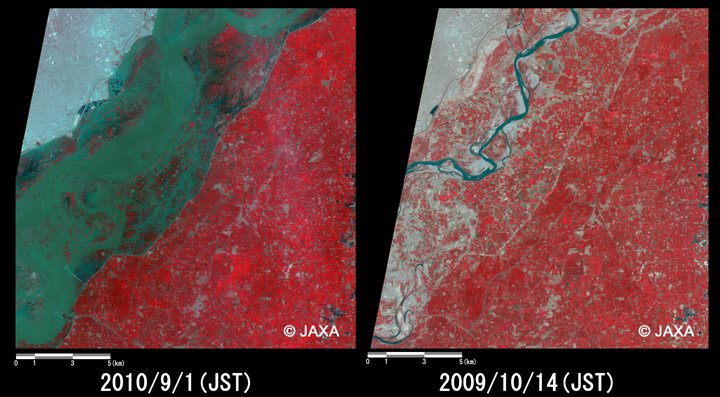
Fig. 2 shows enlarged images of flooded areas in Chund Bharwana, 240 km south-southwest from Islamabad, which were taken after disaster on September 1 (left) and August 6, 2010 (middle), before disaster on October 14, 2009 (right). It is assigned band 4, 3 and 2 of AVNIR-2 as the false color composite, therefore vegetation can be seen in red color and flood areas can be done clear in light gray color.
Fig.2: Enlarged images of the swollen rivers at Chund Bharwana
(324 square kilometers, left: September 1, 2010; middle: August 15, 2010; right: October 14, 2009).
(Click to view enlarged image)
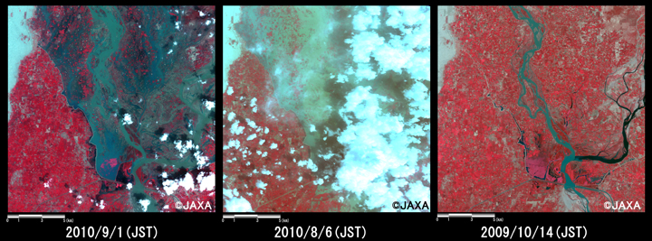
Fig. 3 shows enlarged images of flooded areas in Alhara Hazar, 260 km south-southwest from Islamabad , which were taken after disaster on September 1 (left) and August 6, 2010 (middle), before disaster on October 14, 2009 (right).
In comparison to both Fig. 2 and Fig. 3 that were taken after disaster on August, 2010, and before disaster on October 14, 2010, they indicate that flooded area remains unchanged.
Fig.3: Enlarged images of the swollen rivers at Alhara Hazari
(324 square kilometers, left: September 1, 2010; middle: August 6, 2010; right: October 14, 2009).
(Click to view enlarged image)
Fig. 4 shows enlarged images of swollen rivers in Ghazi, which were taken after disaster on September 1 (left) and before disaster on October 14, 2009 (right).
Fig.4: Enlarged images of the swollen rivers at Ghazi
(324 square kilometers, left: September 1, 2010; right: October 14, 2009).
(Click to view enlarged image)
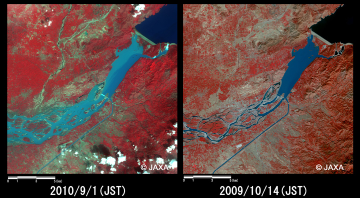
Fig. 5 shows enlarged images of flooded areas, 15 kilometers north from Multan, which were taken after disaster on September 1 (left) and before disaster on October 14, 2009 (right). The location of both Fig.4 and Fig. 5 is 400 kilometers away, in the north-south direction, however both images show rivers widely swelled. Therefore, it indicates that Pakistan still has flood damage in large area. Reconstructions of disaster-stricken area take much time.
Fig.5: Enlarged images of the swollen rivers at Multan
(324 square kilometers, left: September 1, 2010; right: October 14, 2009).
(Click to view enlarged image)
JAXA plans continuous observation of this region.
* Advanced Visible and Near Infrared Radiometer type 2 (AVNIR-2):
AVNIR-2 is a visible and near infrared radiometer for observing land and coastal zones.
It provides 10-m spatial-resolution image and 70-km swath on the ground. The pointing angle of AVNIR-2 is +44 and - 44 degrees. This image was acquired by 0.0 degree. The images taken after disaster on September 1, 2010 was acquired by 0.0 degree. And the images taken on October 14, 2009, August 6 and August 15, 2010 were acquired by 0.0 degree, 38 degrees east and 0.0 degree, respectively.