Image Library
Result of damage interpretations in the Nepal Himalayas using Commercial Very-High-Resolution Satellite Images and ALOS Images
Summary
- Digital Globe, Inc. opens free-access to satellite data for supporting disaster response in Nepal.
- Newly fallen materials to the river are interpreted by comparing their images and the archived ALOS images.
- Large fallings caused by landslide and/or avalanche are recognized in three places in the north of Pokhara.
- The results have been reported to the concerned authorities.
Digital Globe, Inc. (DG) voluntary opens access to their satellite images for supporting disaster response in an earthquake struck Nepal on April 25, 2015 (local time)*. The Japan Aerospace Exploration Agency (JAXA) compared their images and the Advanced Land Observing Satellite (ALOS, "DAICHI") archive images in order to find affected terrains in the Nepal Himalayas in the north of Pokhara (Figure 1).
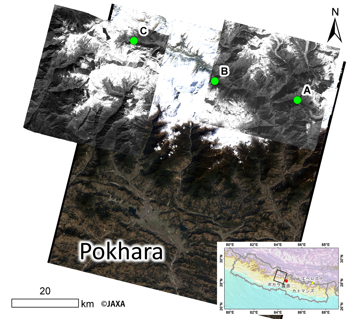
Fig. 1: Three places where large amount of material fell to the river, overlaid on the used ALOS PRISM images. The background image is an ALOS AVNIR-2 image taken on March 10, 2011.
(Click to view enlarged image)
Two material fallings by avalanche and/or landslides reaching the river are interpreted by an image provided by DG acquired on April 29, 2015 at the place A (28°31’32.64”N; 84°26’27.10”E) (Figure 2a). These are not identified in a PRISM image (2.5-m spatial resolution) acquired on January 20, 2010. This difference suggests that the fallings were caused by the earthquake on April 25, 2015. A birds-eye view of the PRISM image overlaid on a PRISM-derived digital surface model shows the material has fallen along a very steep slopes to the river. Although formation of dammed lake is not been identified on April 29, however, it may be caused by seasonal increase of precipitation and melting water of snows and glaciers. Careful monitoring of river flow and terrain feature changes by satellite images and/or other ways may be necessary.
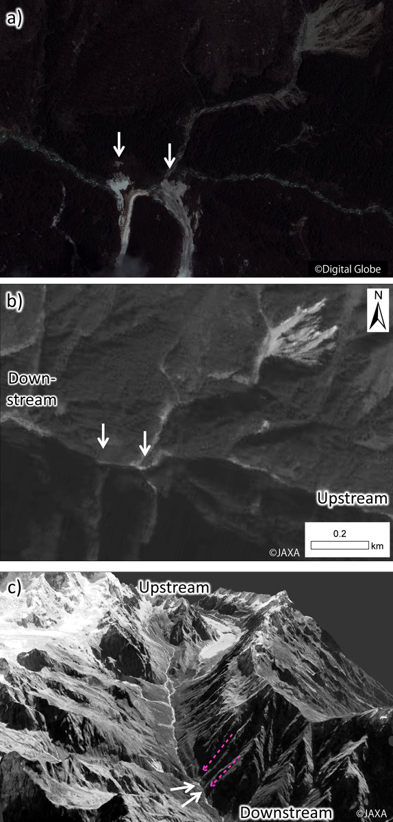
Fig. 2: Material fallings in place A. Glaciers and glacial lakes are located in the upstream. The dashed lines denote falling direction.
(Click to view enlarged image)
A material falling of avalanche and/or landslide reaching to the river is interpreted at the place B (28°34’19”32N; 84°11’12”74E) above the east face of Annapurna II (7973 m ASL) (Figure 3a). A PRISM image taken on January 20, 2010 shows a village (Bhratang) located very near the fallen materials. New falling event from the surrounding steep slopes may be carefully monitored.
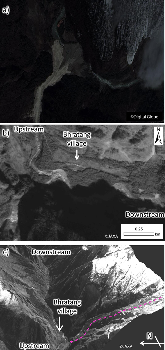
Fig. 3: Material falling interpreted in place B. The dashed-line arrows represent the direction of falling.
(Click to view enlarged image)
In the place C (28°40’32.00”N; E83°56’11.47”E), two neighboring fallings reached to the river flow were interpreted from the DG image on April 29, 2015 (Figure. 4a). This place was observed by ALOS PRISM (Figure 4b) and its birds-eye view shows that this fallings occurred from a steep slope (Figure 4c). Although formation of dammed lake is not been identified on April 29, however, it may be caused by seasonal increase of precipitation as well as melting waters from snow and glaciers. Careful monitoring of river flow and terrain changes by satellites images and/or other ways may be necessary. This place is located in an upstream of the place B, therefore the second disaster should also be carefully.
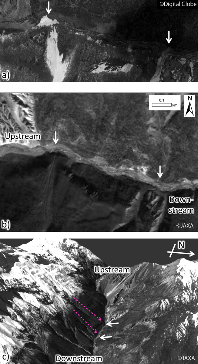
Fig. 4: Material falling interpreted in place C. The dashed-line arrows represent the direction of falling.
(Click to view enlarged image)
Numerous small villages are distributed in the Nepal Himalayas, where are difficult their situations of damages to be confirmed after the earthquake because of limited ways of transportation and communication. The obtained images have been contributed to response by local organization i.e. the International Centre for Integrated Mountain Development (ICIMOD). JAXA will continue the observation in Nepal in cooperation with the concerned authorities. Acquired images and information have been provided to them.
JAXA will continue the observation for Nepal, and report the results to relevant organizations and this website.
See also
JAXA EORC