Dataset
We do not recommend the use of the following data (old version) to our users, as improved versions (the newest version) have been released separately. However, we will continue to provide these data on this page, as we believe that some users may need these data for retrospective or revalidation of researches that have already been conducted.The newest version is here.
Annual Land-Use and Land-Cover Maps of Vietnam from 2015 to 2018
(Released in August 2019 / Version 19.08)
You can switch layers with check boxes.
Download product
User registration is required to download the data. Please click here about download and user registration details.
1. Summary
In recent years, rapid economic growth has caused a significant change in land used and land cover (LULC) in Vietnam. These changes are highlighted by annual LULC maps from 2015 to 2018. The maps were produced by using multi-temporal PALSAR-2/ScanSAR images, multi-temporal MODIS/NDVI images, and SRTM images.
2. Data used for creating the map
- Data 1: Multi-temporal PALSAR-2/ScanSAR 50 m resolution (in 1° × 1° tile size) : 339 scenes (2015), 450 scenes (2016), 506 scenes (2017), 490 scenes (2018).
- Data 2: Multi-temporal Terra MODIS/NDVI 250 m resolution (processed to be 1° x 1° tile size): 339 scenes (2015), 450 scenes (2016), 506 scenes (2017), 490 scenes (2018).
- Data 3: SRTM 30 m resolution (1° × 1° tile size): 60 scenes (2000).
- To cover the mainland of Vietnam (except some remote islands from the continent), we need 60 tiles of 1° × 1°. On a yearly average of a location, we have about 7 scenes of ScanSAR images, 7 scenes of MODIS/NDVI images, and 1 scene of SRTM.
3. Classification algorithm
Bayesian classifier with kernel density estimation (Hashimoto et al., 2014)
4. Data format
- Coordinate system: Latitude and longitude coordinate system with ITRF-94 on GRS-80 ellipsoid.
- Tile unit: 1 degree × 1 degree, (2,250 pixels × 2,250 lines).
- Mesh size: (1 / 2,250) degree × (1 / 2,250) degree (corresponding to approximate 50 m × 50 m).
- File naming convention: For example, N18E105_2015._50m.tif:
- "N18E105" indicates coordinate of the map that is 18 to 19 degrees north latitude and 105 to 106 degrees east longitude.
- "2015" indicates year of the map that is 2015.
- "50m" indicates the spatial resolution that is 50 m. - Format: GeoTIFF.
- Period of coverage: 2015, 2016, 2017, and 2018 (four different maps).
The value of each pixel is ID number of the category for classification as follows:
- #1: Water
- #2: Built-up
- #3: Forest
- #4: Paddy
- #5: Orchards
- #6: Barren
- #7: Other crops
5. Accuracy verification
Tables 1, 2, 3, and 4 present the accuracy of the LULC maps for producers, users, and overall accuracy based on confusion matrices. The overall accuracies of LULC maps are approximately 80 %. Figure 1 shows the 50 m spatial resolution LULC maps of Vietnam from 2015 to 2018, respectively.
Table 1: Accuracy assessment for LULC map of Vietnam in 2015
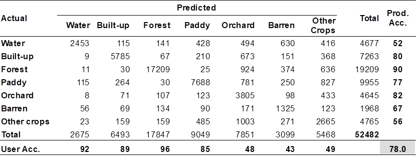
Table 2: Accuracy assessment for LULC map of Vietnam in 2016
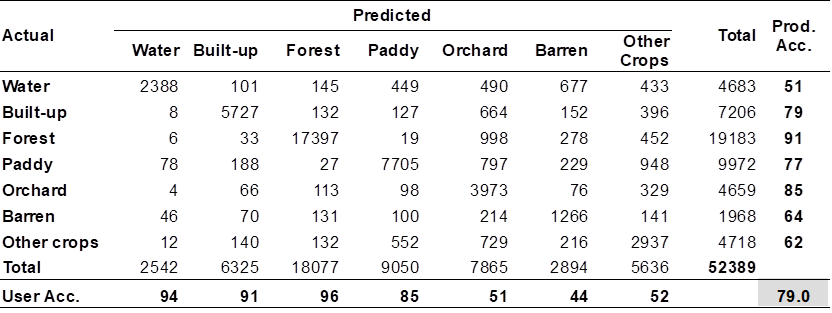
Table 3: Accuracy assessment for LULC map of Vietnam in 2017
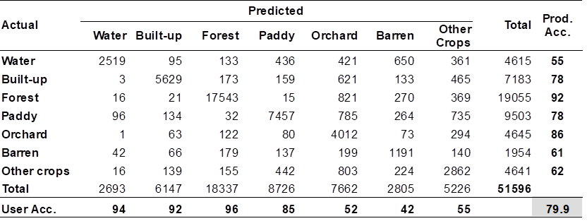
Table 4: Accuracy assessment for LULC map of Vietnam in 2018
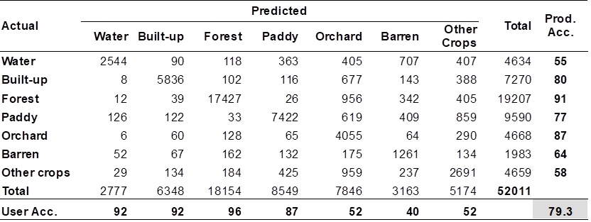
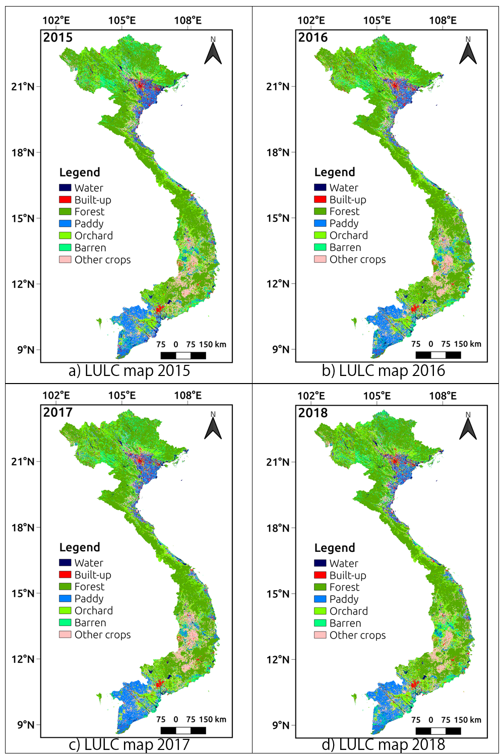
Figure 1: LULC maps in Vietnam from 2015 to 2018.
6. References
- "A New Method to Derive Precise Land-use and Land-cover Maps Using Multi-temporal Optical Data", Shutaro Hashimoto, Takeo Tadono, Masahiko Onosato, Masahiro Hori and Kei Shiomi (2014), Journal of The Remote Sensing Sociery of Japan, 34 (2), 102-112.
- "Analysis of Land Cover Change in Northern Vietnam Using High Resulution Remote Sensing Data", Hoang, T.T., Nasahara, K.N., Katagi, J. (2018), Advances and Applications in Geospatial Technology and Earth Resources. Springer International Publishing, Cham.
- "JAXA High-Resolution Land Use/Land Cover Map for Central Vietnam in 2007 and 2017", Duong, P., Trung, T., Nasahara, K., Tadono, T. (2018), Remote Sens. 10, 1406.
- "Mapping Annual Forest Cover for Vietnam during 2015-2018 Using PALSAR-2 and Ancillary Data", Truong Van Thinh, Master’s thesis, University of Tsukuba, 2019.
Acknowledgements
- Multi-temporal PALSAR-2/ScanSAR mosaic images courtesy of JAXA.
- Multi-temporal MODIS NDVI images and SRTM images courtesy of the U.S. Geological Survey.