Dataset
Precise Global Digital 3D Map "ALOS World 3D"
The Japan Aerospace Exploration Agency (JAXA) is starting to process the precise global digital 3D map using some 3 million data images acquired by the Advanced Land Observing Satellite "DAICHI" (ALOS). The digital 3D map to be compiled this time has the world's best precision of five meters in spatial resolution with five meters height accuracy that enables us to express land terrain all over the world. Hence its strong character will prove useful in various areas including mapping, damage prediction of a natural disaster, water resource research etc.
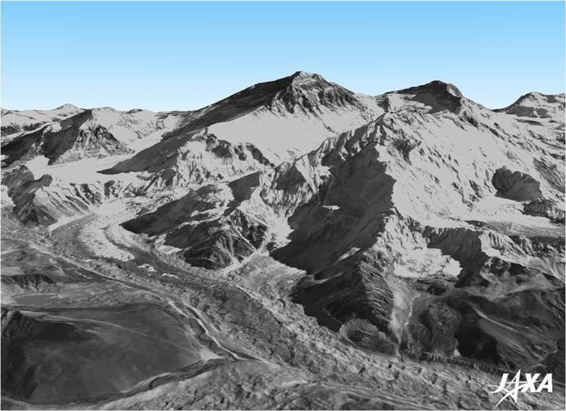
Fig.1: Digital 3D Map Image Example: Mt. Everest
(Click to View Enlarged Image)
JAXA has been processing about 100 digital 3D maps per month as part of our engineering validation activities of DAICHI so for. As we conducted research and development for full automatic and mass processing map compilations, we now have a perspective to process 150,000 maps per month. By applying our research and development results, we will start the 3D map processing in March 2014 to complete the global 3D map in March 2016. JAXA will commission the compiling work and service provision to NTT DATA Corporation and Remote Sensing Technology Center (RESTEC), Japan.
In order to popularize the utilization of the 3D map data, JAXA will also prepare global digital elevation model (DEM) with lower spatial resolution (of about 30 meters under our current plan) to publish it as soon as it is ready. Its use will be free of charge. We expect that data from Japan will become the base map for all global digital 3D maps, and contribute to the expansion of satellite data utilizations and the industrial promotion, science and research activities as well as the Group on Earth Observations. The publication of the lower resolution version of the global DEM will be announced here.
Related Link
- ALOS Global Digital Surface Model "ALOS World 3D - 30m" (AW3D30) dataset https://www.eorc.jaxa.jp/ALOS/en/dataset/aw3d30/aw3d30_e.htm
- NTT DATA Corporation / RESTEC: "AW3D World 3D Topographic Data"
http://aw3d.jp/en/index.html - AW3D Promotion Movie [2016 version] (to move to the YouTube)
https://www.youtube.com/watch?v=YUo9Xgdnn08 - Sample movies of the digital 3D map (to move to the YouTube)
https://www.youtube.com/watch?v=pZg78PXnlQc - About ALOS "DAICHI"
http://global.jaxa.jp/projects/sat/alos/index.html
Digital 3D Map
1. Background
The needs for geographic spatial information are increasing all over the world to organize basic map information and prepare for disasters such as tsunamis and floods, etc. 3D maps are essential for organizing geographic spatial information, but, to date, manpower and airplanes were required to compile 3D maps thus such processes were limited due to cost and time constraints.
The satellite DAICHI* mainly observed land areas all over the globe, but organizing its data to cover such broad areas has stalled due to the constraints of some challenges and the computation ability for automation in 3D mapping technology.
* The Advanced Land Observing Satellite "DAICHI" (ALOS) was launched in January 2006 by JAXA and was used in mission operations for five years and four months till May 2011. It observed various conditions of the Earth till the completion of its operations. DAICHI is equipped with the Panchromatic Remote-sensing instrument for Stereo Mapping (PRISM) that enabled its observations with a high-resolution three-dimensional view.
2. Special features
<What is a digital 3D map?>
A digital 3D map is data with 3D axes of coordinates (geolocation and height). It consists of a DEM (or digital surface model, DSM) and ortho-rectified images that indicate geolocation. An ortho-rectified image is an image that entails correct position information by eliminating terrain distortion on an image that was caused by taking images from above the sky.
<Digital 3D map with highest precision in the world>
The DEM of the digital 3D map to be processed by JAXA will express land undulations all over world with the precision of five meters of spatial resolution (and 2.5 meters for ortho-rectified images) with five meters of height accuracy by utilizing about 3 million data images that are less cloud cover acquired by PRISM aboard "DAICHI".
Figure 2 shows example of DEM/DSM in Thimphu, Kingdom of Bhutan. The left image is a DEM with 5 meters resolution. For your reference, the center image of Fig. 2 shows simulated DEM with 30 meters resolution while that of the right image is 90 meters from the left image.
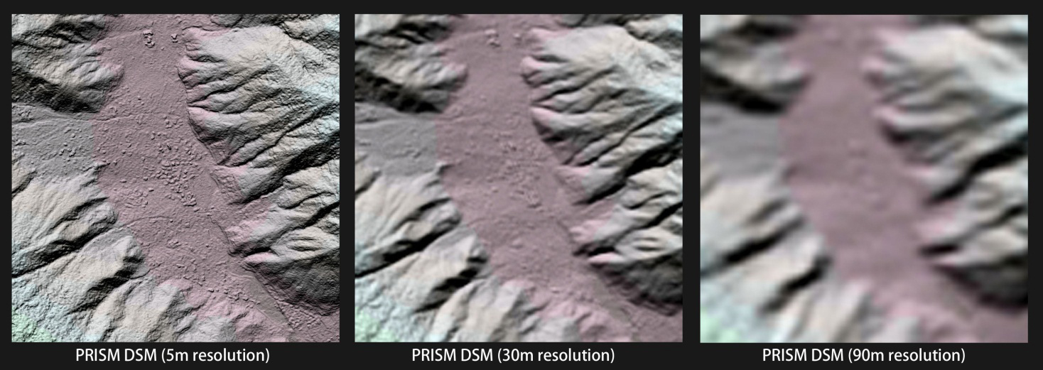
Fig. 2: Example of the PRISM DSM (DEM) in the Kingdom of Bhutan
(Left: 5 meter resolution, center and right: simulated DEMs with 30 meter and 90 meter resolutions for reference)
(Click to View Enlarged Image)