Dataset
ALOS Global Digital Surface Model "ALOS World 3D - 30m (AW3D30)"
- Black is no-data due to clouds, snow and ice. White is a place without tiles.
1. Overview
This data set is a global digital surface model (DSM) with horizontal resolution of approximately 30 meters (basically 1 arcsecond) by the Panchromatic Remote-sensing Instrument for Stereo Mapping (PRISM), which was an optical sensor on board the Advanced Land Observing Satellite "ALOS".
Any of the commercial and non-commercial purposes can be used free of charge under the conditions of the "5. Terms of Use" below.
We hope that this dataset will be widely used in scientific research, education, and new services that use geospatial information.
The latest version consists of the following three versions (see image below). The latest version can be downloaded from this website.

Fig : Version map of AW3D30
Version 4.1 : Global except Japan area and Antarctica
Version 4.0 : Part of Antarctica
Version 3.1 : Japan area, most of Antarctica
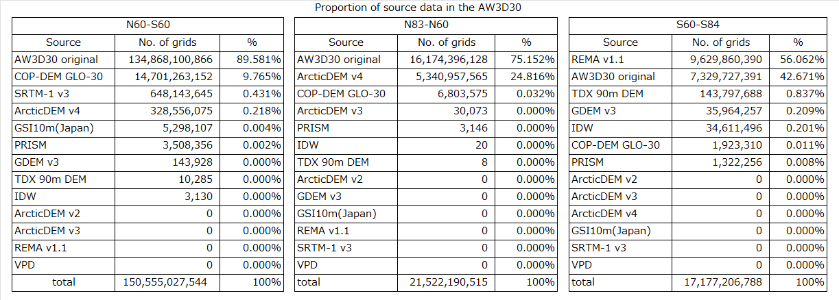
Table : Percentage of AW3D30 data sources (DSM)
2. Release History
March 2025: Updated files for 2 tiles in the Anterctic region (Version 4.0)
- Fixed the file size error for Anterctic 2 tiles(S070E073,S070E074)
April 2024: Improved version, Global (except Anterctic and Japanese regions), 19,051 tiles released (Version 4.1)
- New supplementary data for void filling
- Correction of partial anomaly for AW3D30v3.1,3.2 and re-filling of voids
*For updated tile details in version 4.1, please select v4.1 only on map tiles, or refer to the latest format description.
April 2023: Improved version, low and mid latitude region and Southern region from 60 degrees south , 1,886 tiles released (Version 4.0)
- New supplementary data for void filling
- Correction of partial anomaly and re-filling of voids. (2 tiles)
- Corrected and updated the coastline of Southern region from 60 degrees south (44 tiles)
- Disable Caspian Sea water mask and supplemented with elevation data (54 tiles)
- New partial anomaly areas in South America were extracted and corrected. (1,786 tiles)
*For updated tile details in version 4.0, please select v4.0 only on map tiles, or refer to the latest format description.
February 2022: Improved version, low and mid latitude region, 5 tiles released (Version 3.2)
- Corrected partial anomaly and replaced version 3.1
January 2022: Improved version, low and mid latitude region, 7 tiles released (Version 3.2)
- Corrected partial anomaly and replaced version 3.1
March 2021: Improved version, northern region over 60 degrees north, 2 tiles released (Version 3.2)
- Corrected sea mask and replaced version 3.1
January 2021: Improved version, low latitude region, 19 tiles released (Version 3.2)
- Corrected partial anomaly and replaced version 3.1
- New supplementary data for correction
January 2021: Improved version, southern region over 60 degrees south, 4,814 tiles released (Version 3.1)
- The rest of version 3.1
- Latitude dependent pixel spacing at high latitude area
- Alteration of coastline data
- New supplementary data for void filling
April 2020: Northern region from 60 degrees south, 19,183 tiles released (Version 3.1)
- Latitude dependent pixel spacing at high latitude area
- Alteration of coastline data
- New supplementary data for void filling
- Use of AW3D third edition as a source data (Japan area)
- Southern from 60 degrees south will be created soon (now ver. 1.0 is available)
April 2019: Improved version, northern region over 60 degrees north, 4,448 tiles released (Version 2.2)
- Complement missing tiles in land area with existing DEMs
- Complement "Cloud and snow" pixel and "Land water and low correlation" pixel by existing DEMs
- Update coastline data
- N/A range: version 2.1 and version 1.0 are available
April 2018: Improved version, within 60 degrees of north and south (and part of arctic), 14,535 tiles released (Version 2.1)
- Use AW3D second edition as source data
- Correct absolute offset errors from the ICESat reference
- Correct relative striping errors along satellite orbits by updated calibration
- Complement "Cloud and snow" pixel and "Land water and low correlation" pixel by existing DEMs
- Update coastline in Japan area
- N/A range: version 1.0 is available
March 2017: Complemented version, within 60 degrees of north and south, approximately 10,300 tiles released (Version 1.1)
- Complement "Cloud and snow" pixel by existing DEMs
- N/A range: version 1.0 is available
May 2016: Global land area (within about 82 degrees of latitude), approximately 22,100 tiles released (Version 1.0)
April 2016: Revised version, Japan and a part of individual continent, 7,278 tiles released (Version 1.0)
May/October 2015: Japan and a part of individual continent, 7,279 tiles released (beta version)
3. Data set details
| Product: | ALOS World 3D - 30m (AW3D30) |
|---|---|
| Resolution: | 1 arcsecond (approximately 30 meters), latitude dependent |
| File Unit: | 1 × 1 degree Latitude/Longitude Tile |
| File Composition: | DSM file: Height above sea level (averaged from source AW3D) |
| MSK file: Mask information (Cloud and snow, Sea, DEM information for complement processing) | |
| STK file: Stack number of DSM scenes used to produce source AW3D DSM | |
| QAI file: Quality assurance Information. | |
| HDR file: Meta data about the product | |
| LST file: List of Scene IDs used to produce source AW3D DSM |
4. Download
The dataset is downloadable from following;
To download the data files, you are kindly requested to make your account in the AW3D30 homepage.
User Registration
- Please fill the form in the following URL and send it. Especially please check your email address again.
-
The notification of registration completion will be sent to your email address.
Please access to the URL described in the email and then your account will be activated. - After the account activation, we will send your account information to your email address.
JAXA will not use personal information that you registered for any purpose other than "ALOS World 3D"(AW3D).
Recommend to use Microsoft Edge, Google Chrome, Mozilla Firefox, Apple Safari.
However, it may not be available depending on the version.5. Terms of Use for ALOS Global Digital Surface Model (AW3D30)
This dataset is available to use with no charge under the "Terms for Use".
6. Notes
(1) Access to the data download page
When access to the data download page, you are requested ID and password which are sent by email after completion of user registration. Please make your account in the user registration form.
Username: <ID notified by email>
Password: <password notified by email> (character string excluding blanks only)
Please note that there are a lot of input errors. We recommend that you copy and paste ID and password notified by email.
Be careful not to include blank characters when copying and pacing.
If you make a mistake several times, your web session will be locked. If the session is locked, please wait for more than 20 minutes and try again. The lock will be automatically canceled after 20 minutes. Also, if the notification mail does not arrive or lost, please register again and the latest password will be effective.
(2) Data file
After login to the download page, please click the required data location on the map, you can download data file divided into 1 × 1 degree unit or 5 × 5 degree unit in latitude and longitude.
The downloaded file is compressed into one file by zip. Software may be required for this decompression. For example, 7-Zip is available as free software.
(3) Data Display
The format of DSM data file is GeoTIFF. To display and process the data, software such as image processing, remote sensing, GIS, etc. is required.
(4) Data conversion
Sample script for format conversion from AW3D30 DSM GeoTIFF to SRTM HGT format
(Update:March 15,2019)
This is a sample script to convert AW3D30 DSM file (GeoTIFF) to SRTM HGT format. The sample script use the GDAL for format conversion. Please prepare an environment which can use GDAL. For usage, please refer to "readme-en.txt" composed in the zip file.
(a) System requirements
This sample script operates with Linux system, and requires "GDAL", "bash", and "awk". We also confirmed that the script works on the following environment except for Linux system.
(b) Note: Usage of script
To perform resampling of the edge portion of the tile accurately, AW3D30 for input is needed the tile which is not only the tile you want to convert but also surrounding tiles. Please prepare the AW3D30 data for larger areas than your interest.
(c) Disclaimers
Regardless of the reason, JAXA shall not be made liable for any damage or loss as a result of the use of this sample script.
7. Contact
ALOS Science Project
Earth Observation Research Center (EORC)
Japan Aerospace Exploration Agency (JAXA)
E-mail: aprojectjaxa.jp
8. Reference
J. Takaku, T. Tadono, M. Doutsu, F. Ohgushi, and H. Kai, : “Updates of 'AW3D30' ALOS Global Digital Surface Model in Anterctica with Other Open Access Datasets”, Int. Arch. Photogramm. Remote Sens. Spatial Inf. Sci., XLIII-B4-2021, 401-408, 2021.
T. Tadono, H. Ishida, F. Oda, S. Naito, K. Minakawa, and H. Iwamoto, “Precise Global DEM Generation by ALOS PRISM”, ISPRS Annals of the Photogrammetry, Remote Sensing and Spatial Information Sciences, Vol.II-4, pp.71-76, 2014.
J. Takaku, T. Tadono, and K. Tsutsui, “Generation of High Resolution Global DSM from ALOS PRISM”, The International Archives of the Photogrammetry, Remote Sensing and Spatial Information Sciences, ISPRS, Vol.XL-4, pp.243-248, 2014.
J. Takaku, T. Tadono, K. Tsutsui, and M. Ichikawa, “Validation of 'AW3D' Global DSM Generated from ALOS PRISM”, ISPRS Annals of the Photogrammetry, Remote Sensing and Spatial Information Sciences, Vol.III-4, pp.25-31, 2016.
T. Tadono, H. Nagai, H. Ishida, F. Oda, S. Naito, K. Minakawa, and H. Iwamoto, “Initial Validation of the 30 m-mesh Global Digital Surface Model Generated by ALOS PRISM”, The International Archives of the Photogrammetry, Remote Sensing and Spatial Information Sciences, ISPRS, Vol.XLI-B4, pp.157-162, 2016.
J. Takaku and T. Tadono, “Quality updates of ‘AW3D’ global DSM generated from ALOS PRISM”, Proc. IGARSS2017, IEEE, Fort Worth, TX, USA., pp.5666-5669, 2017.
J. Takaku, T. Tadono, K. Tsutsui, and M. Ichikawa, “Quality Improvements of ‘AW3D’ Global DSM Derived from ALOS PRISM”, Proc. IGARSS2018, IEEE, Valencia, Spain, pp.1612-1615, 2018.
J. Takaku, T. Tadono, M. Doutsu, F. Ohgushi, and H. Kai, “Updates of ‘AW3D30’ ALOS Global Digital Surface Model with Other Open Access Datasets”, The International Archives of the Photogrammetry, Remote Sensing and Spatial Information Sciences, ISPRS, Vol.XLIII-B4-2020, pp.183–189, 2020.