ALOS-3
Overview
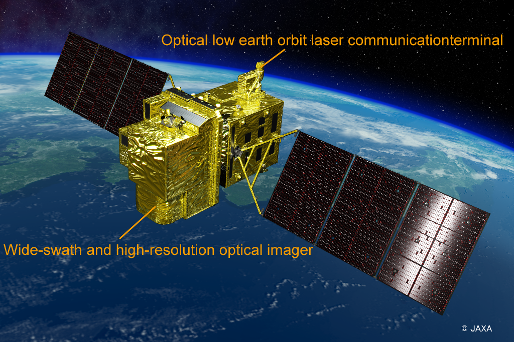
Advanced Land Observing Satellite-3 (ALOS-3)
Important note: We regret to inform you that the Advanced Land Observing Satellite-3 (ALOS-3) was lost due to a launch failure on March 7, 2023.
ALOS-3 was foreseen to be the successor of the optical AVNIR-2 and PRISM of ALOS, "DAICHI". ALOS-3 was to achieve an improved ground resolution (0.8 m) while observing a wide-swath (70 km) by a larger sensor with higher performance compared to ALOS, and continuously observe not only Japan but also global land areas.
Observation data acquired by ALOS-3 was expected to be useful in various fields such as disaster prevention & preparation activities, maintenance & updates of precise geospatial information, and research & applications on coastal & land environmental monitoring.
| Items | Specifications | |
|---|---|---|
| Launch | ||
| Orbit | Type | Sun-synchronous sub-recurrent |
| Altitude | 669 km at the equator | |
| Local Sun Time | 10:30 am +/- 15 minutes at the descending node | |
| Revisit | 35 days (Sub-cycle 3 days) | |
| Mission Instrument | Wide-swath and high-resolution optical imager | |
| Spatial Resolution | Panchromatic (Pa) | 0.8 m GSD, 70km swath @ nadir |
| Multispectral (Mu) | 3.2 m GSD, 70 km swath @ nadir | |
| Swath width | 70km (nadir) | |
| Pointing angle | -60 to +60 degrees | |
| Mission data downlink | - direct transmission (Ka-band: 1.8 Gbps, X-band: 0.8 Gbps) - via optical data relay satellite: 1.8 Gbps |
|
| Mass | 2,900 kg at launch | |
| Size | 5 m×16.5 m×3.6 m on orbit | |
| Duty | 10 mins / recurrent | |
| Design life time | 7 years | |
Fields where ALOS-3 was expected to be utilized
ALOS-3 newly added two new observation wavelengths, Coastal and Red-Edge, aiming to expand the use of observation data by ALOS-3 using six observation bands i.e., Coastal, Blue, Green, Red, RedEdge, and Near-Infrared.
A Coastal band is effective for coastal observations because it does not attenuate easily in water. A RedEdge band is effective for understanding the distribution of plants and their health conditions, as it is strongly reflected from healthy plants.
ALOS-3 would also have provided improved frequency of observations by shortening the revisit to 35 days from 46 days of ALOS.
Some examples of fields where ALOS-3 observation data was expected to be utilized, taking advantage of these features follows below.
-
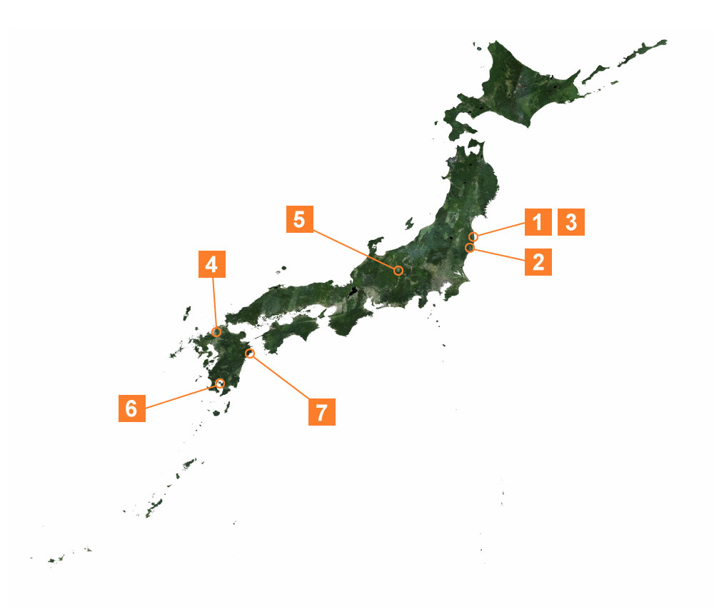
1Emergency observation in the event of a disaster
By comparing images taken before and after a disaster, the extent of the damages can be seen immediately. These figures are images taken by ALOS AVNIR-2 before and after the Great East Japan Earthquake, where were flooded by the tsunami. Satellite images are provided to relevant ministries, local governments, and organizations to help them assess the damages.
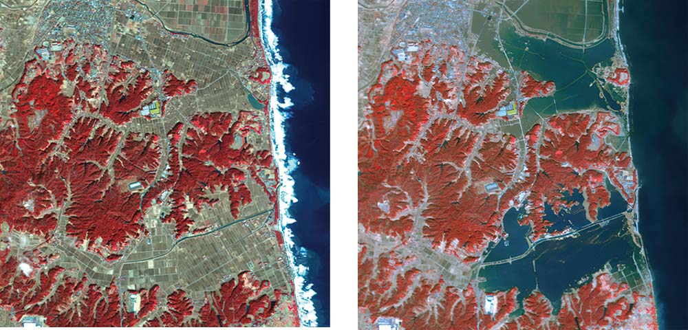
Flooding near Odaka Ward, Minamisoma City, Fukushima Prefecture. Left: Before the disaster (February 23, 2011) / Right: After the disaster (March 14, 2011)
-
2Assessing damage from landslides
These images were acquired by AVNIR-2 onboard ALOS, which capture a landslide site caused by an aftershock of the Great East Japan Earthquake. The sediment was 15 meters wide and 8 meters high, completely blocking two lanes on the downhill side. ALOS-3 has a higher resolution than AVNIR-2, therefore it will be possible to see collapsed buildings and broken roads more clearly.
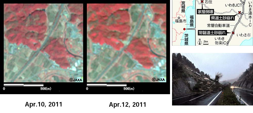
Left and Middle: A landslide in Iwaki City, Fukushima Prefecture. / Right: the location and a picture of the Joban Expressway taken on the ground.
-
3Maintenance and updating of geospatial information
ALOS-3 is expected to be used for geospatial information more than ALOS because it can observe with higher ground resolution than ALOS. In the figure below, land cover and use status are identified by analyzing multispectral images and displayed in different colors. Comparing the past with the latest situation can contribute to the updating of geospatial information.
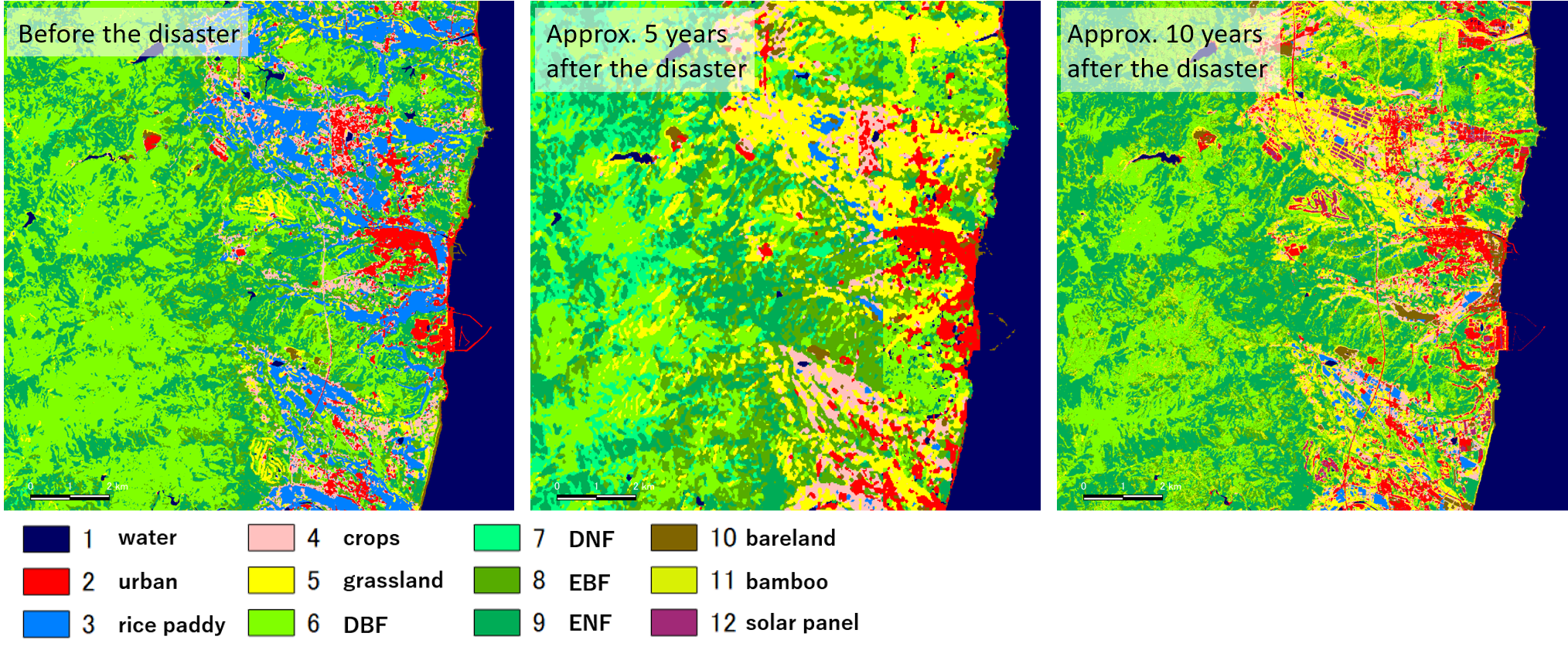
Monitoring of reconstruction and recovery states from the earthquake seen through changes in land cover, near Tomioka Town and Naraha Town, Fukushima Prefecture.
-
4Maintenance and updating of topographic maps
ALOS-3 observation data will be used to develop and update the 1:25,000 scale topographic maps produced by the Geospatial Information Authority of Japan (GSI).The 1:25,000 topographic map is the largest scale topographic map covering the whole country and is used as a base for making other scale maps, road maps, climbing maps, car navigation systems, and many other types of maps.
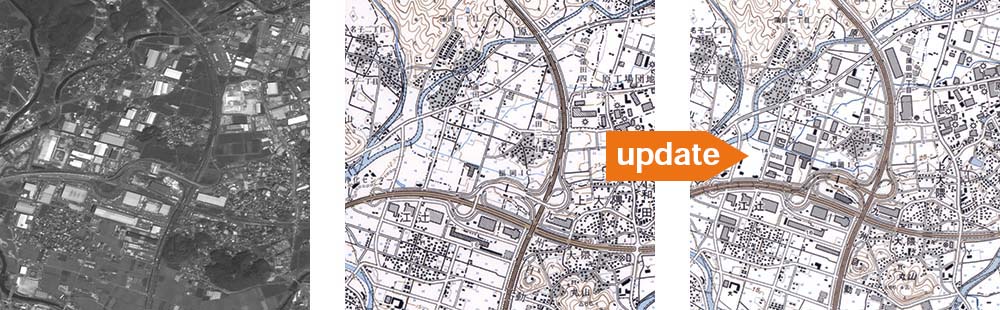
An example of updating a topographic map using ALOS observation data. [Courtesy of Geospatial Information Authority of Japan]
-
5Utilization in vegetation and Forest area (example of pine wilt disease)
ALOS-3 is expected to provide highly accurate information on the damage status of Pine wilt disease, which has been reported nationwide, using six wavelength bands including the RedEdge.
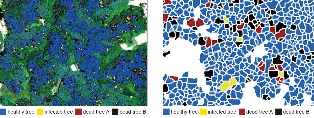
An example of classification results for damaged trees. [Courtesy of Shinshu University, Japan]
-
6Assessing eruption status
The optical satellite image shows the entire ash plume immediately. Periodic ALOS-3 data can also be used to monitor changes in the ash plume.
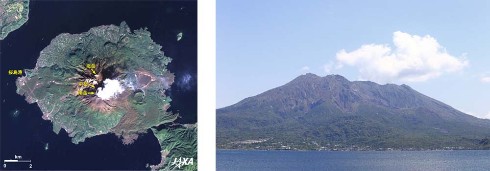
Left: Sakurajima's ash plume taken by AVNIR-2 onboard ALOS. / Right: A ground-based picture.
-
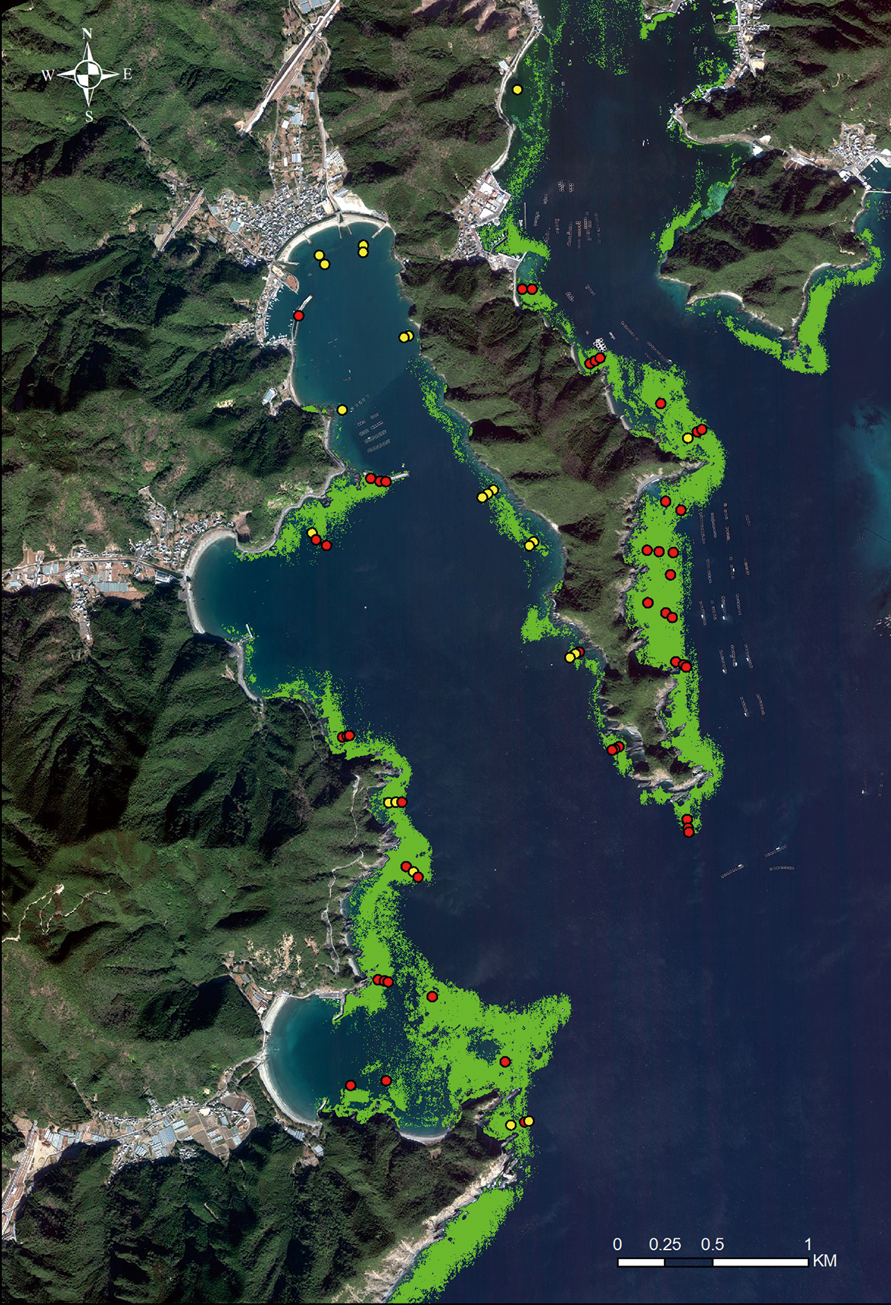
7Utilization in coastal areas (example of seaweed bed)
The distribution of seaweed beds, which are habitats for fish and other aquatic organisms, has been decreasing (rocky-shore denudation) nationwide due to high water temperatures, feeding by herbivorous animals (e.g., sea urchins, siganus, parrotfish), and disturbance by typhoons. ALOS-3 data will make it possible to monitor seaweed beds over a wide area and regularly, and it is expected to confirm changes in seaweed beds and the effects of measures taken against rocky-shore denudation.
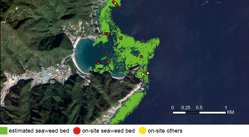
An example of coastal area classification. [Courtesy of Fisheries Technology Research Institute, Japan Fisheries Research and Education Agency]
ALOS-3 simulation image