
Emergency observation and initial GLOF assessment of glacial lakes in
western Bhutan by ALOS-2
Overview
- Glacial Lake Outburst Flood (GLOF) was reported in western Bhutan on Jun. 28, 2015 (local time).
- Emergency observation of PALSAR-2 onboard ALOS-2 was performed on Jul. 2, 2015 by JAXA, corresponding to a request from Sentinel Asia.
- Remarkable change in lake area is recognized in Lake A (ICIMOD id: mo_gl_200). The area increased between Mar. 8 and Apr. 23 (+48.0%) and then decreased between Apr. 23 and Jul. 2 (−52.9%) in 2015.
- Collapse of a moraine edge is recognized near Lake A after the GLOF event.
Corresponding to an emergency request from Sentinel Asia related to a glacial lake outburst flood (GLOF) reported in Bhutan on Jun. 28, 2015, the Japan Aerospace Exploration Agency (JAXA) performed an emergency observation at 5:59 (GMT) on Jul. 2, 2015 by means of the Phased Array type L-band Synthetic Aperture Radar-2 (PALSAR-2) aboard the Advanced Land Observing Satellite-2 (ALOS-2, "DAICHI-2").
According to an ALOS dataset, "the Glacial Lake Inventory of Bhutan using ALOS ("DAICHI") Data", two glacier lakes with GLOF potential as Lake A and B are located in [89°34'50.0"E; 28°4'7.7"N] and [89°36'7.7"E; 28°6'54.1"N] in a headwater of the Mo Chu river basin, western Bhutan.
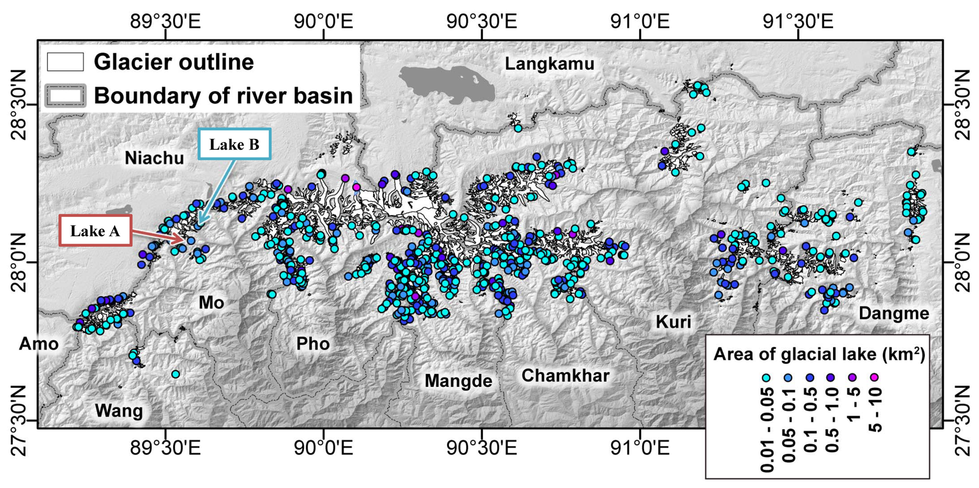 Fig.1: Location of glacier lakes in the Bhutan Himalaya.
Lake position and area are originated from "Glacial Lake Inventory of Bhutan using ALOS (Daichi) Data".
Glacier outlines are originated from Nagai et al. (2014).
(Click to view enlarged image)
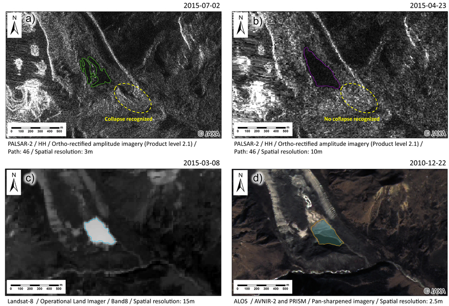
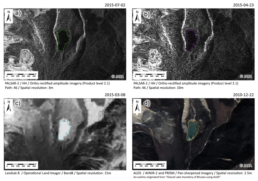
Lake outline was delineated manually for Lake A (Fig. 2a) and B (Fig. 3a). In a PALSAR-2 image, lakes are shown as homogeneously dark areas, because low backscatters return from the water surface, which enables manual delineation of lake outlines from an amplitude image. Lake outlines before the GLOF were also delineated from past images of PALSAR-2 (Apr. 23, 2015) (Figs. 2b; 3b), Landsat 8 (Mar. 8, 2015) (Figs. 2c; 3c), and ALOS PRISM/AVNIR-2 (Dec. 22, 2010) (Figs. 2d; 3d).
(Click to view enlarged image)
(Click to view enlarged image)
The outline differences of Lake A denotes a remarkable expansion (+48.0%) from Mar. 8 to Apr. 23 followed by a remarkable shrinkage (−52.9%) from Apr. 23 to Jul. 2 (Fig. 4). On the other hand, no remarkable area change is recognized (< 20.0%) in Lake B in the same period.
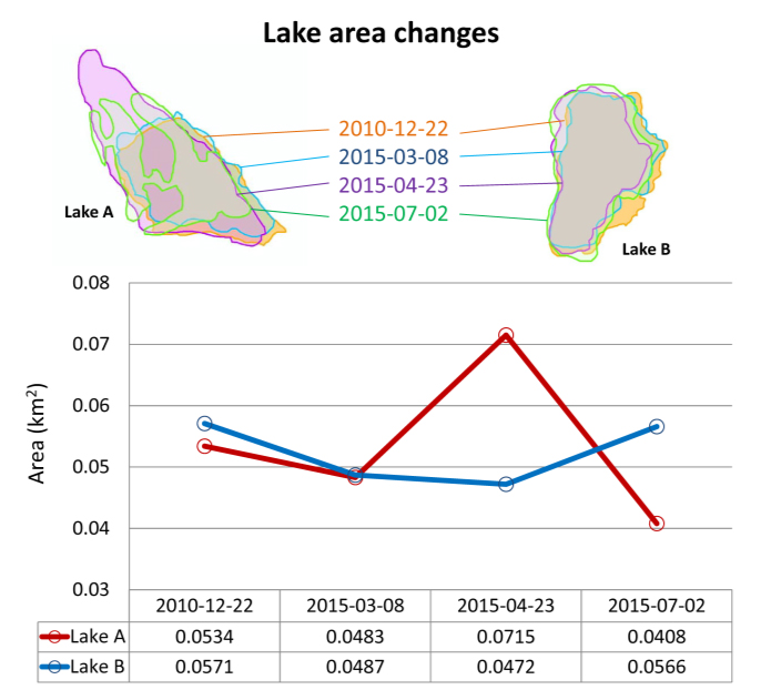 Fig.4: Temporal area changes of Lake A and B.
From this result, Lake A has a higher potential as the source of the GLOF. It is located at a glacier terminus surrounded by a moraine (Fig. 5). Comparison of Figs. 2a and 2b denotes different backscatters in a part of the moraine, which suggests that the moraine was collapsed by the GLOF. More detail investigations including field surveys are necessary to reveal and understand this event scientifically.
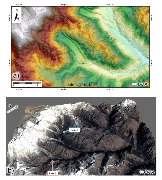
(b) 3D view around Lakes A and B derived from ALOS digital surface model and pan-sharpened imagery (Dec. 22, 2010).
(Click to view enlarged image)
These obtained results have been contributed to a governmental organization of Bhutan. JAXA would carry out rapid observations against such a mountain hazard in remote regions in cooperation with concerned authorities. Related results would be distributed to relevant organizations and this website.
JAXA has been providing "Glacial Lake Inventory of Bhutan using ALOS (Daichi) Data" which contains glacial lake outlines and related geographical information for the glacial lakes in the Bhutan Himalaya. This project was supported by JICA and JST under SATREPS from 2008 to 2012.
http://www.eorc.jaxa.jp/ALOS/en/bhutan_gli/index.htm
Digitized outlines of Lake A and B (zipped KML files; 30 KB) are able to be downloaded from » here.
© JAXA EORC
© Copyright 1997- All Rights Reserved.