

| |

| 
|
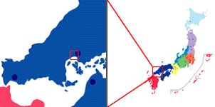
The National Space Development Agency of Japan (NASDA) received on September 5, 1996, at its Earth Observation Center (EOC) located in Hatoyama, Saitama Pref., the first image taken using the panchromatic band (resolution: approx. 8 m) of an Earth observing sensor called the Advanced Visible and Near-infrared Radiometer (AVNIR) aboard the Advanced Earth Observing Satellite (ADEOS) launched from NASDA's Tanegashima Space Center on August 17 this year.
The image released today show Hiroshima Pref., of Japan. ADEOS took it using the pointing function of AVNIR at approx. 11:30 a.m. JST on September 5 when the satellite was flying about 800 km above the East China Sea.
The first image show us the city of Hiroshima, and the area indicated on this image is approx. 8 km X 10 km. On the other hand, the second image is the enlarged version of Hiroshima City, and the area seen on the second image is approx. 1,400 m X 600 m.
Image acquisition of this time was done as part of AVNIR checkouts following image acquisition using multi-spectral bands of AVNIR conducted on September 1 and for calibration of the equipment. NASDA continues the checkouts regarding the ground segments as well as those in space.
AVNIR data will be used for environmental awareness and monitoring of such phenomena as desertification, destruction of tropical rain forests, and pollution of coastal zones, as well as for resources exploration, land use, etc.


| 
|
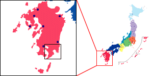
The National Space Development Agency of Japan (NASDA) received on September 1, 1996, at its Earth Observation Center in Hatoyama, Saitama Pref., the first image taken using the multi-spectrum band of a Earth observing sensor called the Advanced Visible and Near-infrared Radiometer or AVNIR aboard a remote sensing satellite ADEOS.
The image is of Kagoshima Pref., a southern part of Japan. ADEOS took it using the pointing function of AVNIR at 11:38 am JST when the satellite was flying about 800km above the East China Sea. The image is about 80km wide.
This image acquisition was a part of AVNIR checkouts which include image acquisition by the panchromatic band and calibration of equipment. NASDA continues the checkouts regarding the ground segments as well as those in space.
1. Advanced Visible and Near Infrared Radiometer (AVNIR) Instrument
Characteristics
AVNIR is an optical sensor with 4 spectral bands used to observe land and
coastal zones in the visible and near-infrared regions. The 3 bands in the
visible region correspond approximately to blue, green and red while the
near-infrared band is suited to observing plant growth. In addition to these 4
bands, called the Multispectral Band, AVNIR has a Panchromatic band whose
spatial resolution is twice as high.
AVNIR utilizes large linear-array CCDs with 5,000 pixels for the Multispectral band and 10,000 pixels for the Panchromatic band. AVNIR scans the earth's surface in an 80 Km (ground distance) swath perpendicular to the satellite track. Due to the narrow swath width of 80 Km AVNIR has a pointing function which can change the location of the observation field by +/- 40 degrees from the satellite track.
Main Characteristics of AVNIR:
| Multispectral Bands (Mu) (micro meter) |
0.42 Ĺ` 0.50 |
|---|---|
| 0.52 Ĺ` 0.60 | |
| 0.61 Ĺ` 0.69 | |
| 0.76 Ĺ` 0.89 | |
| Panchromatic Band (Pa) (micro meter) | 0.52 Ĺ` 0.69 |
| Data Rate | 60Mbps |
| Spatial resolution | 16mĹiMuĹj |
| 8mĹiPaĹj | |
| Swath Width | 80km |
| Pointing Range | +/-40 degrees |
| Pointing Step | 1degree |
2. Expected Result
AVNIR is a high resolution sensor designed to observe land and coastal zones
which have a changeable topography. AVNIR data can be used to determine soil and
plant conditions which will aid in understanding global environmental problems
such as desertification and decreasing tropical rain forests. Observation and
study of green plant and building distribution within cities may be helpful in
improving urban living environments. AVNIR can also observe the reflective
characteristics of the ground surface and the atmosphere and these data may play
a significant role in evaluating energy influx and expenditure on the ground
surface.
The earth environmental problems derive from regional/local environmental problems. Thus, it is important to have a high resolution means of understanding localized phenomena.
3.Comparison of Optical Sensors(OPS)
| ADEOS AVNIR | JERS-1 OPS | MOS-1 MESSR | LANDSAT TM | SPOT HRV |
|
|---|---|---|---|---|---|
| Observation Wavelength Bands (micro meter) |
Mu 0.42Ĺ`0.50 0.52Ĺ`0.60 0.61Ĺ`0.69 0.76Ĺ`0.89 Pa 0.52Ĺ`0.69 |
0.52Ĺ`0.60 0.63Ĺ`0.69 0.76Ĺ`0.86 1.60Ĺ`1.71 2.01Ĺ`2.12 2.13Ĺ`2.25 2.27Ĺ`2.40 |
0.51Ĺ`0.59 0.61Ĺ`0.69 0.72Ĺ`0.80 0.80Ĺ`1.10 |
0.45Ĺ`0.52 0.52Ĺ`0.60 0.63Ĺ`0.69 0.76Ĺ`0.90 1.55Ĺ`1.75 10.40Ĺ`12.50 2.08Ĺ`2.35 |
Mu 0.50Ĺ`0.59 0.61Ĺ`0.68 0.79Ĺ`0.89 Pa 0.51Ĺ`0.73 |
| Visible Near Infrared | Visible Near Infrared Shortwave Infrared | Visible Near infrared | Visible Near Infrared Shortwave Infrared Thermal Infrared | Visible Near infrared |
|
| Panchromatic band | O | X | X | X | O |
| Resolution | Mu 16m Pa 8m | 18.3mX24.2m | 50m | 30m 120mĹiThermal InfraredĹj | Mu
20m Pa 10m |
| Pointing | O | X | X | X | O |
| Stereo | O | O | X | X | O |
Comments to: adeossupport@eorc.nasda.go.jp
Last Update: 11 November 1996