
 |
 |
The National Space Development Agency of Japan (NASDA) released on September 4 two images taken by the Ocean Color and Temperature Scanner (OCTS) aboard the Advanced Earth Observing Satellite (ADEOS) when the satellite was flying approximately 800 km above the Pacific Coast in the Eastern Japan at 10:44 A.M. JST on September 3.
The image released today is the one which had been processed for analysis purposes. It consists of detailed data showing density distribution of chlorophyll-a contained in vegetable plankton. The area showed in the image is 1,000 km X 1,000 km, and resolution is about 700 m.
In this image, the Japanese Islands and the sea around them observed by OCTS' observation bands in the visible and near-infrared region is seen. The image shows density distribution of chlorophyll-a in the sea. The red area means highest density while the blue area indicate lower density. OCTS is able to acquire data as above of the whole earth once every three days.
Moreover, the first image taken by NASA's Total Ozone Mapping Spectrometer (TOMS) expected to be released on Sept. 14 (Saturday) has been postponed to the morning of 17 (Tuesday).


| 
|
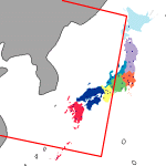
This image shows the surface temperature of the Sea of Japan and the East China Sea at about 11:32am JST on October 1, 1996. The image, which covers an about 1,400km (in the direction of the observation span of the sensor) x 2,000km (in the forward direction of the satellite) area, was taken at the infrared bands by the Ocean Color and Temperature Scanner (OCTS) aboard the Advanced Earth Observation Satellite (ADEOS). The image was taken and processed as to verify the sensor's function. Apart from land and the clouds, the temperature of a place is shown by its color which is defined, by the color bar at the right-bottom corner of the image, that the temperature increases as the color changes from violet to red, while the absolute value of the temperature will be determined by future calibration. Land, like the Kyushu island and the Korean peninsula seen in the center, is shown black in the image, and the clouds whose temperature is below -2 degree Celsius is shown white.
Part of the warm Kuroshio Current can be seen streaming from the East China Sea to the Sea of Japan through the Tsushima and Korea Straits, where the name of the current is changed to the Tsushima Current. Cold water from a river is spreading along the coast near Vladivostok. The surface temperature of the sea is changing drastically along the front where the cold water in the north part of the Sea of Japan and the warm Tsushima Current meet and vortexes in various sizes are being generated. This area forms so good a fishery that more fishes are said to be here than in a place which has plain distribution of its water surface temperature. According to a fishery information provider, it turned out that the area which have vortexes, north of the Yamato bank, coincides approximately with a fishery of squids, while the areas right south of Cheju-do Isaland and right north of Tsushima Islands correspond with a fishery of mackerel. More specified determination of the positions of fisheries can be achieved by the combination of such an image as this, showing the distribution of the surface temperature of the sea, and such, showing the distribution of the concentration of plant plankton's pigments, as one which was published on September 13, 1996.
OCTS can obtain this kind of images from the whole sphere within each three days. After ADEOS goes into the routine operation phase in mid-November, the OCTS data at infrared wavelength will be transmitted on quasi-real time basis to Japan's Meteorological Agency and a fishery information provider in order to be used for such as weather forecasts and fishery estimates.

| 
|
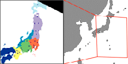
This image shows the surface temperature of the area around the Yamato bank in the middle of the Sea of Japan and Vladivostok, at about 11:32am JST, October 1, 1996. The temperature of a place is shown by its color which is defined, by the color bar at the right-bottom corner of the image, that the temperature increases as the color changes from violet to red, while the absolute value of the temperature will be determined by future calibration. White parts in the image show clouds. The absolute value of the temperature will be determined by future calibration of Ocean Color and Tempreature Scanner (OCTS).
A warm water vortex revolving clockwise can be seen red in the center of the image and cold water seen in the north part of the Sea of Japan. The East Korea Warm Current which has come up along the coast of the Korean peninsula is recognized brown or red as it is flowing near the coast of the continent.
This image was taken by OCTS at a infrared band ranging from 10.3 to 11.4 microns in wave length. While the data was kept on the satellite, the amount of it had been reduced to one-tenth of the original. Then the lightened data was sent to the ground, received a portable receiver possible to be carried on a ship, and then processed by a personal computer.
While the images available this time are taken only at the infrared band, the coming routine operation of OCTS will provide with data at both the visible near-infrared bands and the thermal infrared bands which represent respectively the surface temperature of the sea and the distribution of concentration of plant plankton's pigments. Such data are expected to be used effectively in fishery. The OCTS data already obtained will be compared with ground truth data from ships, jointly by National Space Development Agency of Japan (NASDA) and other entities like Japan*s Fisheries Agency, and will be used to optimize the image processing method.
The surface temperature of the sea is an important index for ocean
observation.
It provides significant information regarding the behavior of water
including
ocean currents, the formation of fisheries, and the inflow and diffusion
of
water from rivers and factories. Surveys by ships, however, take much
time and
the ships themselves may disturb the status of water which is the object
of the
surveys. The observation at infrared wavelength by OCTS is appropriate to
broad range surveys of the surface temperature of the sea, because OCTS
enables
to:
- observe a broad area within a short period;
- thus obtain the distribution of data not as a single point nor a line
but as
a plane;
- observe the objects without disturbing them as OCTS keeps away from
them.


| 
|
Japan and it's surrounding waters can be seen in this OCTS visible and near-infrared band image. The image is 2,500 km long in the direction of the satellite flight path and has a 1,400 km swath width. This initial image processing, which confirms proper sensor function, will be improved in the coming months.
Clouds due to typhoon 14 are visible on the Pacific side of Japan. Strong sunlight reflection from the sea surface is visible in part of the image, but this can be removed during the operational phase of image processing.
OCTS can scan the entire earth about every 3 days. The resulting knowledge of the distribution and density of phytoplankton in the sea will be utilized in research on biochemical phenomena and gas absorption in the ocean. In addition, water temperature can also be measured. This combined information will be useful in forecasting fishing grounds and weather.
OCTS is an optical sensor which measures radiation reflected from the earth's surface and operates in 12 bands, visible to thermal-infrared. Eight visible to near-infrared bands are used to observe ocean conditions and pigment density of phytoplankton. Four thermal-infrared bands are used to measure ocean temperature.
OCTS method of observation is to scan a north/south track along the satellite's flight path, and an east/west track created by tilting a mirror. These two scan methods combine to allow the OCTS sensor to observe a global area. The east/west swath, produced by the tilting mirror, is 1,400 km wide on the earth's surface. OCTS can observe the entire earth's surface in about 3 days, with a spatial resolution of about 700 m.
The sea surface reflects direct sunlight (sun glitter) which interferes with satellite measurement. It is not possible to observe an area that is reflecting just above sunlight directly into the instrument. However, OCTS has a tilting mechanism which can change the direction of observation by +/- 20 degrees along the track to avoid sun glitter.
Two types of OCTS data are transmitted to ground stations. One type is
precision image data, which includes observation and adjustment data
transmitted from the Direct Transmission subsystem (DT) or Inter Orbit
Communication Subsystem (IOCS). The other is a less detailed image which
consists of 4 bands of data of 6 x 6 km regions transmitted by Direct
Transmission for Local users (DTL), which ships can receive.
| Satellite | ADEOS | NIMBUS-7 | Sea Star | |||
|---|---|---|---|---|---|---|
| Sensor | OCTS (Launch date 1996.8.17) | CZCS*1 (Launch date 1978.10.24) | Sea
WiFS*2 |
|||
| Observation Wavelength Bands (micro meter) |
Visible/Near Infrared | Visible/Near Infrared | Visible/Near Infrared | |||
| Center of Wave length | Band Width | Center of Wave length | Band Width | Center of Wave length | Band Width | |
| 0.412 | 0.020 | 0.412 | 0.020 | |||
| 0.443*3 | 0.020 | 0.443 | 0.020 | 0.443 | 0.020 | |
| 0.490 | 0.022 | 0.490 | 0.020 | |||
| 0.520 | 0.018 | 0.520 | 0.020 | 0.510 | 0.020 | |
| 0.565*3 | 0.020 | 0.550 | 0.020 | 0.555 | 0.020 | |
| 0.670*3 | 0.020 | 0.670 | 0.020 | 0.670 | 0.020 | |
| 0.765 | 0.040 | 0.750 | 0.100 | 0.765 | 0.040 | |
| 0.865 | 0.040 | 0.865 | 0.040 | |||
| Shortwave Infrared | Thermal Infrared | |||||
| 3.35Ĺ`3.88 | ||||||
| 8.25Ĺ`8.80 | ||||||
| 10.3Ĺ`11.4*3 | 10.5Ĺ`12.5 | |||||
| 11.4Ĺ`12.7 | ||||||
| Resolution | 0.7km | 0.825km | 1.13km | |||
| Swath Width | 1400km | 1556km | 2802km | |||
| Others | Ocean Color Sea Surface Temperature Develped by NASDA |
Ocean Color Sea Surface Temperature Develped by NASA Oct. 1987 - June.1986 |
Ocean Color Develped by NASA |
|||
Comments to: adeossupport@eorc.nasda.go.jp
Last Update: 11 November 1996