P-Tree System
JAXA Himawari Monitor

JAXA's P-Tree system will expand the longitude range of "Himawari L1 Gridded data" (full-disk coverage) to longitudes from 70 deg E to 150 deg W in order to connect the observation area with other geostationary satellites such as MTG operated by EUMETSAT.
Until Janualy 5, 2026, L1 gridded data will be available in duplicate with the current area-range data, and from Janualy 6, 2026 (TBD), only the new expansion version will be provided. In addition, we plan to switch the area of the geophysical data such as sea color, solar radiation, water temperature, and clouds sequentially (ocean color, solar radiation, and photosynthetically available radiation will be switched as the first step).
Along with the above, the longitude range of RGB images and thermal infrared images displayed on the Himawari Monitor homepage will also be expanded. The wavelength of thermal infrared band will be changed from 11.2um (band 14) to 10.4um (band 13) to match the wavelengths of the band of the European geostationary sensor MTG/FCI. The RGB and thermal infrared images (70W-70E, 60N-60S) from MTG are shown in the Himawari Monitor homepage.
In principle, there is no change in the algorithm except for the gridded size. In addition, there is no change in the area size of the 0.01 deg gridded L1 data around Japan and JMA’s Himawari standard data (HSD).
JAXA's P-Tree system, that provides multi-satellite products, releases the geostationary satellite Himawari Standard Data provided by the Japan Meteorological Agency (JMA) as well as the geophysical parameter data produced by JAXA using the Himawari Standard Data.
| Observation area | Full-disk |
|---|---|
| Temporal resolution | 10-minute |
| Spatial resolution | 0.5km (band 3), 1km (band 1,2,4), 2km (band 5-16) |
| Observation area | Japan area (Region 1 & 2) |
|---|---|
| Temporal resolution | 2.5-minute |
| Spatial resolution | 0.5km (band 3), 1km (band 1,2,4), 2km (band 5-16) |
| Observation area | Target Area (Region 3) |
|---|---|
| Temporal resolution | 2.5-minute |
| Spatial resolution | 0.5km (band 3), 1km (band 1,2,4), 2km (band 5-16) |
| Note | png images of Full-disk, Japan area and Target area, compositing three visible bands (blue: 0.47 micron; green: 0.51 micron; red: 0.64 micron). | 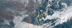 Color Image Data |
|---|
Extension of longitude range of Himawari L1 gridded data.
In order to connect the observation area with other geostationary satellite data, we will expand the longitude range of the "Himawari L1 Gridded Data (Full-disk coverage)" from the conventional area of 80 deg E to 160 deg W to one of 70 deg E to 150 deg W longitude. As a result, the pixel size (image width) of the data will be increased from 6001 to 7001 and from 2401 to 2801 for 0.02-deg resolution data and 0.05-deg resolution data respectively.
| File type | NetCDF | |
|---|---|---|
| Projection | EQR | |
| Observation area | 60S-60N, 70E-150W | |
| Temporal resolution | 10-minute | |
| Spatial resolution | 5km (Pixel number: 2801, Line number: 2401) 2km (Pixel number: 7001, Line number: 6001) | |
| Data |
albedo(reflectance*cos(SOZ) of band01~band06) Brightness temperature of band07~band16 satellite zenith angle, satellite azimuth angle, solar zenith angle, solar azimuth angle, observation hours (UT) |
|
| File type | NetCDF | |
|---|---|---|
| Projection | EQR | |
| Observation area | 24N-50N, 123E-150E | |
| Temporal resolution | 10-minute | |
| Spatial resolution | 1km (Pixel number: 2701, Line number: 2601) | |
| Data |
albedo(reflectance*cos(SOZ) of band01~band06) Brightness temperature of band07, 14, 15 satellite zenith angle, satellite azimuth angle, solar zenith angle, solar azimuth angle, observation hours (UT) |
|
| File type | NetCDF |  Aerosol Optical Thickness |
|---|---|---|
| Latest version | 3.1 | |
| Observation area | Full-disk | |
| Temporal resolution | 10-minute (Level 2), 1-hour (Level 3), 1-day (Level 3), 1-month (Level 3) | |
| Spatial resolution | 5km (Pixel number: 2401, Line number: 2401) | |
| Data | Angstrom exponent, Aerosol optical thickness at 500nm, Uncertainty of aerosol optical thickness, QA flag | |
| Note |
JAXA Himawari Monitor aerosol products reference
Validation with MODIS product Improvement in Version 3.1:
|
|
| File type | NetCDF |  Cloud Optical Thickness |
|---|---|---|
| Latest version | 1.0 | |
| Observation area | Full-disk | |
| Temporal resolution | 10-minute (Level 2) | |
| Spatial resolution | 5km (Pixel number: 2401, Line number: 2401) | |
| Data |
Cloud optical thickness, Cloud effective radius,
Cloud top temperature, Cloud top height, Cloud types (ISCCP Definition) |
|
| File type | NetCDF(GDS2.0) | 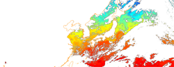 Sea Surface Temperature |
|---|---|---|
| Latest version | 2.1 (Level 2 & Level 3 hourly) & 2.2 (Level 3 daily & monthly) | |
| Observation area | Full-disk | |
| Temporal resolution | 10-minute (Level 2), 1-hour (Level 3), 1-day(Level 3), 1-month (Level 3) | |
| Spatial resolution | 2km (Pixel number: 6001, Line number: 6001) | |
| Data |
Sea Surface Temperature (Please refer to the GDS2.0 format for other data included in 10-min, hourly and daily products.) |
|
| Notice | After uploading the standard product, the near-realtime (NRT) product will be removed from the server 72 hours after observation. | |
| Note |
File version index (fv) Himawari SST product file has a file version index (fvXX) in the filename to describe the number of processing times. File version index will be updated for example when the L3 product file will be re-generated due to L1 missing or delay. The P-tree system distributes the newest product file regarding the file version index. Improvement in Version 2.0 The SST method has been updated with an improved optimal estimation scheme and some minor changes. Cloud masking has been updated with additional use of visible and short wavelength infrared data and a new test to detect clouds with the cloud top temperature higher than SST. In the update, some tests were modified based on the cloud masking developed for SGLI SST. 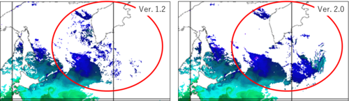
Validation with the in-situ SST data (iQuam) Improvement in Version 2.1 Small changes were made for Himawari-9 data processing.The Bi-Spectral Filter (DOI: 10.1175/JTECH-D-22-0051.1) is applied for denoising the AHI infrared data. Changes in calculation method for SSES(*)in Version 2.1 SSES, which was given as a function of cloud probability in the previous method, is provided by the difference of AHI SST from in situ drifting buoy SST. In the new method, a unique value of SSES is identified depending on a satellite zenith angle. The algorithm version is not changed, while the file version of reprocessing products before March 31 2025 is changed from fv01 to fv02. *SSES (single sensor error statistics): The SSES include bias and standard deviation relative to the agreed reference source of drifting buoys and are supported by a quality level. Improvement in Version 2.2 Daily SST data is calculated from hourly data (Level 3) instead of 10-minute data (Level 2). In addition to the "daily minimum SST" originally provided, "daily mean SST" and "daily maximum SST" are added to Level 3 daily file. Himawari Monitor Web Site continues to visualize the "daily minimum SST." Monthly SST data is calculated from daily mean SST data instead of hourly SST data. |
|
| File type | NetCDF(GDS2.0) |  Sea Surface Temperature(Night Mode) |
|---|---|---|
| Latest version | 2.1 (Level 2 & Level 3 hourly) & 2.2 (Level 3 daily & monthly) | |
| Observation area | Full-disk | |
| Temporal resolution | 1-hour (Level 3) | |
| Spatial resolution | 2km (Pixel number: 6001, Line number: 6001) | |
| Data | Please refer to the GDS2.0 format | |
| Notice | After uploading the standard product, the near-realtime (NRT) product will be removed from the server 72 hours after observation. | |
| Note |
File version index (fv) Himawari SST product file has a file version index (fvXX) in the filename to describe the number of processing times. File version index will be updated for example when the L3 product file will be re-generated due to L1 missing or delay. The P-tree system distributes the newest product file regarding the file version index. Improvement in Version 2.0 The SST method has been updated with an improved optimal estimation scheme and some minor changes. Cloud masking has been updated with additional use of visible and short wavelength infrared data and a new test to detect clouds with the cloud top temperature higher than SST. In the update, some tests were modified based on the cloud masking developed for SGLI SST.
Validation with the in-situ SST data (iQuam) Improvement in Version 2.1 Small changes were made for Himawari-9 data processing.The Bi-Spectral Filter (DOI: 10.1175/JTECH-D-22-0051.1) is applied for denoising the AHI infrared data. Improvement in Version 2.2 Daily SST data is calculated from hourly data (Level 3) instead of 10-minute data (Level 2). In addition to the "daily minimum SST" originally provided, "daily mean SST" and "daily maximum SST" are added to Level 3 daily file. Himawari Monitor Web Site continues to visualize the "daily minimum SST." Monthly SST data is calculated from daily mean SST data instead of hourly SST data. |
|
| File type | NetCDF |  Short Wave Radiation |
|---|---|---|
| Latest version | 2.1 | |
| Observation area |
Full-disk (Himawari area: 70E-150W and 60N-60S) Full-disk (MTG area: 70W-70E and 60N-60S) | |
| Temporal resolution | 10-minute (Level 2), 1-hour (Level 3), 1-day (Level 3), 1-month (Level 3) | |
| Spatial resolution |
5km (Pixel number: 2801, Line number: 2401) 1km Japan* (Pixel number: 2701, Line number: 2601) *Rectangular area: 24N-50N, 123E-150E
|
|
| Data | Total atmosphere optical thickness of band 2, Total atmosphere angstrom exponent, Photosynthetically active radiation, Shortwave radiation, UltraViolet-A radiation, UltraViolet-B radiation | |
| Notice |
Ver. 2.0:
|
|
| File type | NetCDF |  Chlorophyll-a |
|---|---|---|
| Latest version | 2.1 | |
| Observation area |
Full-disk (Himawari area: 70E-150W and 60N-60S) Full-disk (MTG area: 70W-70E and 60N-60S) |
|
| Temporal resolution | 1-hour (Level 3), 1-day (Level 3), 1-month (Level 3) | |
| Spatial resolution |
5km (Pixel number: 2801, Line number: 2401) 1km Japan* (Pixel number: 2701, Line number: 2601) *Rectangular area: 24N-50N, 123E-150E
|
|
| Data | Water-leaving reflectance of band 01~03, chlorophyll-a concentration, absorption coefficient of phytoplankton+cdom+detritus, absorption coefficient of particles, Aerosol optical thickness of band 2, Aerosol angstrom exponent | |
| Notice |
Ver. 2.0:
|
|
| File type | csv (format: Level 2 | Level 3) | 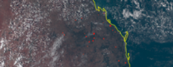 Wild Fire |
|---|---|---|
| Latest version | 1.0 | |
| Observation area | Full-disk | |
| Temporal resolution | 10-minute (Level 2), 1-hour (Level 3), 1-day (Level 3), 1-month (Level 3) | |
| Spatial resolution | 2km (10-minute, 1-hour, and 1-day), 0.25degree (1-month) | |
| File type | NetCDF | 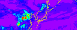 Aerosol Optical Thickness |
|---|---|---|
| Latest version | Version Beta | |
| Area | Global | |
| Temporal resolution | 1-hour (Level 4) | |
| Spatial resolution |
Longitude 0.375 deg., Latitude 0.37147 to 0.37461 deg. (Gaussian) (Pixel number: 960, Line number: 480) |
|
| Data | Aerosol optical thickness at 550 nm (Sulfate, BC, Organic Aerosol, Sea Salt, Dust), PM2.5 surface conc., PM10 surface conc. | |
| Notice | This product is a beta version and is intended to show the preliminary result from Himawari-8. Users should keep in mind that the data is NOT quality assured. | |
| Note | This product is the forecast (every one hour) of aerosol properties by the MRI/JMA global aerosol model called Model of Aerosol Species IN the Global AtmospheRe (MASINGAR). This product is assimilated by Himawari L3 aerosol optical depth at 00, 03, 06, and 09UTC. The opposite side of the Himawari observation area is assimilated at 12 and 18UTC using MODIS/Terra+Aqua L3 Value-added Aerosol Optical Depth - NRT dataset due to lack of aerosol retrievals by Himawari. (As for the image on the top page, there are cases where preliminary forecast is displayed that was derived by assimilating observation data before the previous day.) Please refer to the reference below for the assimilation method etc. The aerosol data assimilation system based on MASINGER was developed by Meteorological Research Institute and Kyushu University. The products are produced at Meteorological Research Institute, and provided by JAXA P-Tree System, Japan Aerospace Exploration Agency (JAXA). | |
| Acknowledgements | MODIS/Terra+Aqua L3 Value-added Aerosol Optical Depth - NRT datasets were acquired from the Level-1 and Atmosphere Archive & Distribution System (LAADS) Distributed Active Archive Center (DAAC), located in the Goddard Space Flight Center in Greenbelt, Maryland (https://ladsweb.nascom.nasa.gov/). | |
| Monitor | https://www.eorc.jaxa.jp/ptree/aerosol_model/index.html | |
| File type | NetCDF | 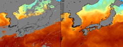 Sea Surface Temperature (Left: Observation by Himawari, Right: Model assimilation) There is no missing area in the simulated ocean and we are able to forecast a state of ocean. |
|---|---|---|
| Latest version | v20180705 | |
| Area | Around Japan (117E-150E, 17N-50N) | |
| Temporal resolution | 1-hour (Level 4) | |
| Spatial resolution |
About 3km (1/36 deg.) (Pixel number: 1190, Line number: 1190) |
|
| Data | Sea Surface Temperature | |
| Note |
This product is constructed by data assimilation using high resolution regional ocean model "JCOPE-T" developed by JAMSTEC and observation data including the 6 types* satellite SST data provided by JAXA. * SSTs by Himawai-8/AHI, GCOM-W/AMSR2, GPM-Core/GMI, Windsat/Colioris, GCOM-C/SGLI and NPP/VIIRS. SGLI and VIIRS SSTs have been added to the assimilation system since Nov. 14, 2019. When we do the data assimilation, we do the bias correction of satellite SST data using GCOM-W/AMSR2 SST data as refer to reference value, because the bias in observation data is undesirable for data assimilation. Near Real-Time data (analysis and forecast) and Best Estimate data are included in this product. Update frequency and period are follow. Near Real-Time data: Daily update. - Analysis (ANAL): recent 7-day (replaced at every update) - Forecast (FCST): future 10-day (replaced at every update) Best Estimate data: Weekly update (update in the beginning of week; Sunday or Monday) - This is delay mode data which is provided with latency of about two weeks. - 7-day data are added at every update. This work has been done under the joint research between JAXA and JAMSTEC, and as a part of the Japan Coastal Ocean Predictability Experiment (JCOPE). |
|
| Monitor | https://www.eorc.jaxa.jp/ptree/ocean_model/index_3km.html | |
| File type | NetCDF | 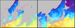 Sea Surface Temperature (Left: Observation by Himawari, Right: Model assimilation) There is no missing area in the simulated ocean and we are able to forecast a state of ocean. |
|---|---|---|
| Latest version | v202501.1 | |
| Area | Around Japan (117.5E-149.5E, 17.5N-49.5N) | |
| Temporal resolution | 1-hour (Level 4) | |
| Spatial resolution |
About 1km (1/120 deg.) (Pixel number: 3842, Line number: 3842) |
|
| Data | Sea Surface Temperature | |
| Note |
JCOPE-T 1ks (1 km scale) (Wang et al., 2025) is a high-resolution ocean weather forecasting system developed through refinement of JCOPE-T DA (Data Assimilation) (Miyazawa et al., 2021). While JCOPE-T DA assimilates satellite sea surface height, satellite sea surface temperature, and in-situ temperature and salinity using multiscale 3DVAR in daily basis, JCOPE-T 1ks ajdusts temperature and salinity fields to be consistent with those of JCOPE-T DA. Note that no adjustment is applied in areas shallower than 200 m. Update frequency and period are follow. Near Real-Time data: Daily update. - Analysis (ANAL): recent 3-day (replaced at every update) - Forecast (FCST): future 9-day (replaced at every update) This work has been done under the joint research between JAXA and JAMSTEC, and as a part of the Japan Coastal Ocean Predictability Experiment (JCOPE). |
|
| Document | ||
| Monitor | https://www.eorc.jaxa.jp/ptree/ocean_model/index.html | |
| File type | NetCDF | Sea Surface Temperature (Left: Observation by Himawari, Right: Model assimilation) There is no missing area in the simulated ocean and we are able to forecast a state of ocean. |
|---|---|---|
| Latest version | 1.0 (10.57746/EO.01hc1e0qpr8z5jmn7cnwwrf3j5) | |
| Area | Western North Pacific (108°E-180°, 12°N-50°N), Maritime Continent (95°E-136°E, 18°S-30°N) | |
| Temporal resolution | 1 day (Level 4) | |
| Spatial resolution | About 10 km (0.1 degree), 50 σ-layers | |
| Data |
|
|
| Note |
An ensemble ocean analysis product, LORA, is created by a regional ocean data assimilation system, sbPOM-LETKF, which is developed by RIKEN. sbPOM-LETKF assimilates the following satellite and in-situ observations at a 1-day interval:
This product has been created under a JAXA-RIKEN collaborative research project. (The temporal coverage is from August 2015 to January 2024. Due to the termination of the atmospheric forcing dataset (JRA55-do) required for creating the LORA at the end of January 2024, we have suspended its creation since then. Currently, we are considering alternative datasets.) |
|
| Monitor | https://www.eorc.jaxa.jp/ptree/LORA/index.html | |
Please specify the following sentence when you publish a thesis, a report, and so on by using the research products and images supplied by the Service.
"'Research product of XXX (produced from Himawari-8) that was used in this paper' was supplied by the P-Tree System, Japan Aerospace Exploration Agency (JAXA)."
Please specify the following sentence when you publish a thesis, a report, and so on by using model product supplied by the Service.
For Aerosol model:
"Aerosol model product that was used in this paper was developed by Meteorological Research Institute and Kyushu University, and supplied by the P-Tree System, Japan Aerospace Exploration Agency (JAXA)."
For Sea Surface Temperature model (JAXA/JAMSTEC):
"Sea Surface Temperature model product that was used in this paper was developed by Japan Agency for Marine-earth Science and Technology (JAMSTEC), and supplied by the P-Tree System, Japan Aerospace Exploration Agency (JAXA)."
For Ocean analysis product model (JAXA/RIKEN):
"Ocean model product that was used in this paper was jointly developed by the Japan Aerospace Exploration Agency (JAXA) and RIKEN and supplied by the JAXA P-Tree System.""Ocean model product that was used in this paper was jointly developed by the Japan Aerospace Exploration Agency (JAXA) and RIKEN and supplied by the JAXA P-Tree System."
If you are writing a document (including papers and thesis), please refer to the algorithm papers of the product you are using, which is listed in the following section "7. References".
If there are any concerns or questions about the Service, please contact us at the following:
| following: | JAXA/EORC P-Tree secretariat |
|---|---|
| Location: |
Japan Aerospace Exploration Agency (JAXA) Space Technology Directorate I, Earth Observation Research Center (EORC) 2-1-1 Sengen, Tsukuba, Ibaraki, 305-8505 |
| E-mail: |  |
Operational information of the geostationary Himawari-8 and -9 satellites is available from the JMA's web site;
Operational schedule of Himawari satellites (https://www.data.jma.go.jp/mscweb/en/oper/operation.html)
The Himawari-8/9 Imaging Schedule is available from the JMA's web site.
Please note that no observations are planned at 0240-0250UTC and 1440-1450UTC everyday for house-keeping of the Himawai-8 and -9 satellites.
Timetable of Himawari-8/9 Imaging
K. Bessho et al., 2016: An introduction to Himawari-8/9 - Japan's new-generation geostationary meteorological satellites, J. Meteorol. Soc. Japan, 94, doi:10.2151/jmsj.2016-009.
https://www.jstage.jst.go.jp/article/jmsj/94/2/94_2016-009/_article
Y. Kurihara et al., 2021: A quasi-physical sea surface temperature method for the split-window data from the Second-generation Global Imager (SGLI) onboard the Global Change Observation Mission-Climate (GCOM-C) satellitei.
Remote Sensing of Environment
https://doi.org/10.1016/j.rse.2021.112347
Y. Kurihara, H. Murakami, and M. Kachi, 2016: Sea surface temperature from the new Japanese geostationary meteorological Himawari-8 satellite.
Geophys. Res. Letters. DOI: 10.1002/2015GL067159.
http://onlinelibrary.wiley.com/doi/10.1002/2015GL067159/full
Y. Kurihara, 2022: A bi-spectral approach for destriping and denoising the sea surface temperature from SGLI thermal infrared data. J. Atmos.
Oceanic Technol., DOI:10.1175/JTECH-D-22-0051.1.
https://doi.org/10.1175/JTECH-D-22-0051.1
(Ocean model)
Varlamov, S. M., X. Guo, T. Miyama, K. Ichikawa, T. Waseda, and Y. Miyazawa, 2015: M2 baroclinic tide variability modulated by the ocean circulation south of Japan, J. Geophys. Res. Oceans, 120, 3681-3710. DOI:10.1002/2015JC010739.
https://agupubs.onlinelibrary.wiley.com/doi/full/10.1002/2015JC010739.
Miyazawa, Y., S. M. Varlamov, T. Miyama, Y. Kurihara, H. Murakami, M. Kachi, 2021: A Nowcast/Forecast System for Japan’s Coasts Using Daily Assimilation of Remote Sensing and In Situ Data. Remote Sens., 13, 2431.
https://doi.org/10.3390/rs13132431.
Miyazawa, Y., S. M. Varlamov, T. Miyama, X. Guo, T. Hihara, K. Kiyomatsu, M. Kachi, Y. Kurihara, H. Murakami, 2017: Assimilation of high-resolution sea surface temperature data into an operational nowcast/forecast system around Japan using a multi-scale three-dimensional variational scheme, Ocean Dyn., 67, 713-728. DOI: 10.1007/s10236-017-1056-1.
https://link.springer.com/article/10.1007/s10236-017-1056-1.
Ohishi, S., T. Miyoshi, T. Ando, T. Higashiuwatoko, E. Yoshizawa, H. Murakami, M. Kachi, 2024: LETKF-based Ocean Research Analysis (LORA) version 1.0, Geoscience Data Journal, 11, 995-1006, DOI: 10.1002/gdj3.271
https://doi.org/10.1002/gdj3.271
Ohishi, S., T. Hihara, H. Aiki, J. Ishizaka, Y. Miyazawa, M. Kachi, and T. Miyoshi, 2022: An ensemble Kalman filter system with the Stony Brook Parallel Ocean Model v1.0, Geosci. Model Dev., 15, 8395?8410, DOI:10.5194/gmd-15-8395-2022.
https://gmd.copernicus.org/articles/15/8395/2022/
Ohishi, S., T. Miyoshi, and M. Kachi, 2022: An ensemble Kalman filter-based ocean data assimilation system improved by adaptive observation error inflation (AOEI), Geosci. Model Dev., 15, 9057?9073, DOI:10.5194/gmd-15-9057-2022.
https://gmd.copernicus.org/articles/15/9057/2022/
Ohishi, S., T. Miyoshi, and M. Kachi: LORA: A local ensemble transform Kalman filter-based ocean research analysis, Ocn. Dyn., DOI: 10.1007/s10236-023-01541-3.
https://doi.org/10.1007/s10236-023-01541-3
(L2 Aerosol Algorithm)
Yoshida, M., Yumimoto, K., Nagao, T. M., Tanaka, T., Kikuchi, M., and Murakami, H.: Retrieval of Aerosol Combined with Assimilated Forecast, Atmos. Chem. Phys., 21, 1797, 2021.
https://doi.org/10.5194/acp-21-1797-2021.
Yoshida, M, M. Kikuchi, T. M. Nagao, H. Murakami, T. Nomaki, and A. Higurashi, 2018: Common retrieval of aerosol properties for imaging satellite sensors, J. Meteor. Soc. Japan, doi:10.2151/jmsj.2018-039.
https://www.jstage.jst.go.jp/article/jmsj/advpub/0/advpub_2018-039/_article/-char/en.
(L3 Hourly Aerosol Algorithm)
Kikuchi, M., H. Murakami, K. Suzuki, T. M. Nagao, and A. Higurashi, Improved Hourly Estimates of Aerosol Optical Thickness using Spatiotemporal Variability Derived from Himawari-8 Geostationary Satellite, IEEE Transactions on Geoscience and Remote Sensing, accepted.
https://ieeexplore.ieee.org/document/8334203/.
(assimilation method)
Yumimoto, K., Tanaka, T. Y., Oshima, N., and Maki, T, 2017: JRAero: the Japanese Reanalysis for Aerosol v1.0, Geosci. Model Dev., 10, 3225-3253
https://doi.org/10.5194/gmd-10-3225-2017.
(assimilation with Himawari-8 Aerosol optical properties)
Yumimoto, K., T. Y. Tanaka, M. Yoshida, M. Kikuchi, T. M. Nagao, H. Murakami, and T. Maki, 2018: Assimilation and forecasting experiment for heavy Siberian wildfire smoke in May 2016 with Himawari-8 aerosol optical thickness. J. Meteor. Soc. Japan, 96B
http://jmsj.metsoc.jp/GA/JMSJ2018-035.html.
(quotation for MODIS assimilation)
MODIS/Terra+Aqua Near Real Time value-added Aerosol Optical Depth Product, 6.1NRT, L2 Swath 1 km and 5 km, C6, NASA Level-1 and Atmosphere Archive & Distribution System (LAADS) Distributed Active Archive Center (DAAC), Goddard Space Flight Center, Greenbelt, MD.
http://dx.doi.org/10.5067/MODIS/MCDAODHD.NRT.061.
R. Frouin and H. Murakami, 2007: Estimating photosynthetically available radiation at the ocean surface from ADEOS-II global imager data. J. Oceanography, 63, 493-503.
(JMA Objective Analysis data (Ozone) used as ancirally data since Ver.2.0)
JMA 2019, OUTLINE OF THE OPERATIONAL NUMERICAL WEATHER PREDICTION AT THE JAPAN METEOROLOGICAL AGENCY, March 2019, Appendix to WMO TECHNICAL PROGRESS REPORT ON THE GLOBAL DATA-PROCESSING AND FORECASTING SYSTEM AND NUMERICAL WEATHER PREDICTION, https://www.jma.go.jp/jma/jma-eng/jma-center/nwp/outline2019-nwp/index.htm
Murakami, H. (2016): Ocean color estimation by Himawari-8/AHI, Proc. SPIE 9878, Remote Sensing of the Oceans and Inland Waters: Techniques, Applications, and Challenges, 987810 (May 7, 2016); doi:10.1117/12.2225422;
http://dx.doi.org/10.1117/12.2225422.
(JMA Objective Analysis data (Ozone) used as ancirally data since Ver.2.0)
JMA 2019, OUTLINE OF THE OPERATIONAL NUMERICAL WEATHER PREDICTION AT THE JAPAN METEOROLOGICAL AGENCY, March 2019, Appendix to WMO TECHNICAL PROGRESS REPORT ON THE GLOBAL DATA-PROCESSING AND FORECASTING SYSTEM AND NUMERICAL WEATHER PREDICTION, https://www.jma.go.jp/jma/jma-eng/jma-center/nwp/outline2019-nwp/index.htm
Ishida, H., and T. Y. Nakajima, 2009: Development of an unbiased cloud detection algorithm for a spaceborne multispectral imager, J. Geophys. Res., 114, D07206, doi:10.1029/2008JD010710.
Ishida, H., T. Y. Nakajima, T. Yokota, N. Kikuchi, and H. Watanabe, 2011: Investigation of GOSAT TANSO-CAI cloud screening ability through an inter-satellite comparison, J. Appl. Meteor. Climatol., 50, 1571?1586. doi: http://dx.doi.org/10.1175/2011JAMC2672.1.
Letu, H., T. M. Nagao, T. Y. Nakajima, and Y. Matsumae, 2014: Method for validating cloud mask obtained from satellite measurements using ground-based sky camera. Applied optics, 53(31), 7523-7533.
Nakajima, T. Y., T. Tsuchiya, H. Ishida, and H. Shimoda, 2011: Cloud detection performance of spaceborne visible-to-infrared multispectral imagers. Applied Optics, 50, 2601-2616.
(Cloud Retrieval Algorithm)Kawamoto, K., T. Nakajima, and T. Y. Nakajima, 2001: A Global Determination of Cloud Microphysics with AVHRR Remote Sensing, J. Clim., 14(9), 2054?2068, doi:10.1175/1520-0442(2001)014<2054:AGDOCM>2.0.CO;2.
Nakajima, T. Y., and T. Nakajima, 1995: Wide-Area Determination of Cloud Microphysical Properties from NOAA AVHRR Measurements for FIRE and ASTEX Regions, J. Atmos. Sci., 52(23), 4043?4059, doi:10.1175/1520-0469(1995)052<4043:WADOCM>2.0.CO;2.
(Scattering property database for nonspherical ice particles)Ishimoto, H., K. Masuda., Y. Mano, N. Orikasa, and A. Uchiyama, 2012a, Optical modeling of irregularly shaped ice particles in convective cirrus. In radiation processed in the atmosphere and ocean (IRS2012): Proceedings of the International Radiation Symposium (IRC/IAMAS) 1531, 184-187.
Ishimoto, H., K. Masuda, Y. Mano, N. Orikasa, and A. Uchiyama, 2012b: Irregularly shaped ice aggregates in optical modeling of convectively generated ice clouds, J. Quant. Spectrosc. Radiat. Transfer, 113, 632?643.
Masuda, K., H. Ishimoto, and Y. Mano, 2012: Efficient method of computing a geometric optics integral for light scattering, Meteorology and Geophysics ., 63, 15?19.
Letu, H., T. Y. Nakajima, and T. N. Matsui, 2012: Development of an ice crystal scattering database for the global change observation mission/second generation global imager satellite mission: Investigating the refractive index grid system and potential retrieval error. Appl. Opt., 51, 6172-6178.
Letu, H. H. Ishimoto, J. Riedi, T. Y. Nakajima, L. C.-Labonnote, A. J. Baran, T. M. Nagao, and M. Sekiguchi, 2016: Investigation of ice particle habits to be used for ice cloud remote sensing for the GCOM-C satellite mission. Atmos. Chem. Phys, 16(18), 12287-12303.
Letu, H., T. M. Nagao, T. Y. Nakajima J. Riedi, H. Ishimoto, A. J. Baran, H. Shang, M. Sekiguchi, and M. Kikuchi: Ice cloud properties from Himawari-8/AHI next-generation geostationary satellite: Capability of the AHI to monitor the DC cloud generation process. IEEE Transactions on Geoscience and Remote Sensing, in revision.
Nakajima, T., and M. Tanaka (1986), Matrix formulation for the transfer of solar radiation in a plane-parallel scattering atmosphere, J. Quant. Spectrosc. Radiat. Transfer, 35, 13?21, doi:10.1016/0022-4073(86)90088-9.
Nakajima, T., and M. Tanaka (1988), Algorithms for radiative intensity calculations in moderately thick atmospheres using a truncation approximation, J. Quant. Spectrosc. Radiat. Transfer, 40, 51?69, doi:10.1016/0022-4073(88)90031-3.
Ota, Y., A. Higurashi, T. Nakajima, and T. Yokota (2009), Matrix formulations of radiative transfer including the polarization effect in a coupled atmosphere-ocean system, J. Quant. Spectrosc. Radiat. Transfer, 111, 878?894, doi:10.1016/j.jqsrt.2009.11.021.
Y. Kurihara, K. Tanada, H. Murakami, and M. Kachi, 2020: Australian bushfire captured by AHI/Himawari-8 and SGLI/GCOM-C. JpGU-AGU Joint Meeting 2020.
Presentation Material