Seen from Space 2010
Uraga and Yokosuka, Japan
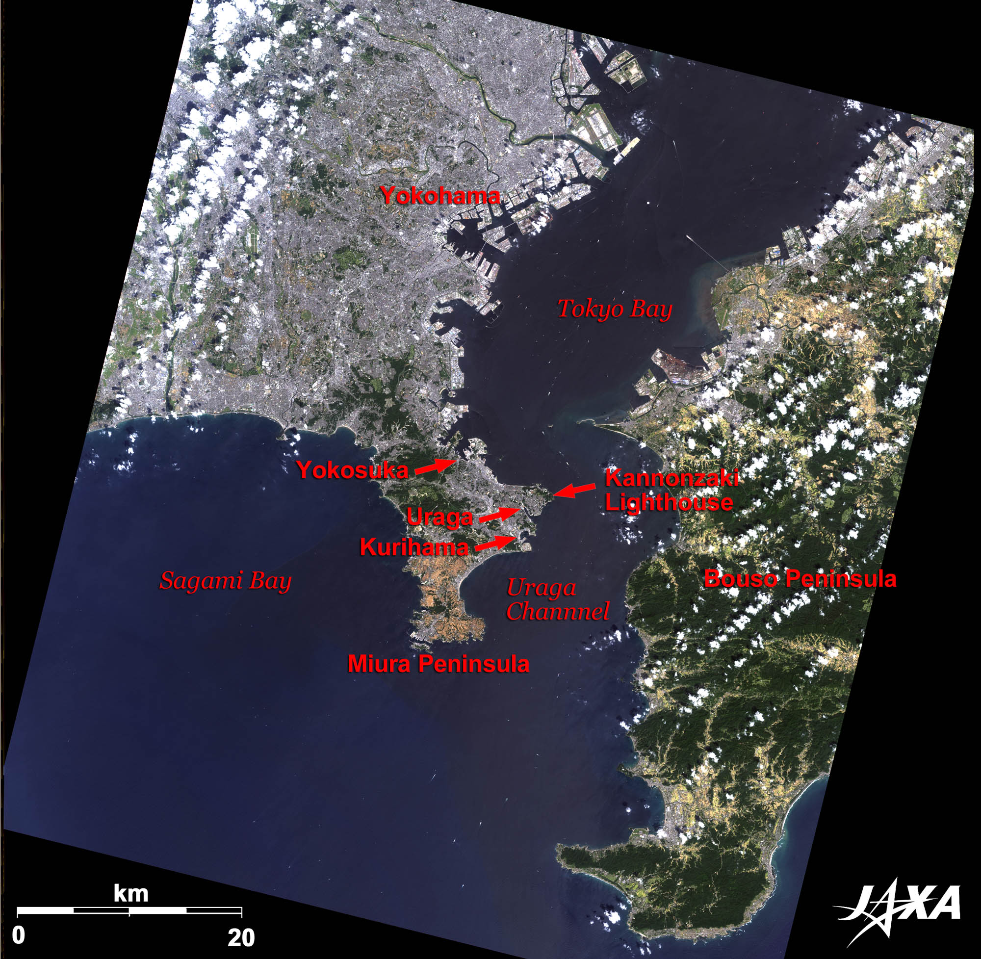 
Fig. 1. The Miura Peninsula and Its Surroundings
Figure 1 is an image of the Miura Peninsula and its surroundings taken by ALOS (Daichi) on September 6, 2009. The Uraga channel, a gateway to Tokyo Bay between the Miura Peninsula (on the left) and the Bouso Peninsula (on the right), is visible in the center of the image. Over 500 ships, including cargo ships, container ships, and tankers, pass through the channel each day, making it one of the busiest sea routes in the world. Uraga and Kurihama are famous in Japan for being the location where Commodore Perry’s fleet first landed. Uraga, Kurihama, and Yokosuka are located on the east side of the Miura Peninsula and face the Uraga channel. The Kan-nonzaki lighthouse, the first Western style lighthouse in Japan, was built at the eastern end of the Peninsula in 1868. Tokyo Bay Marine Traffic Center, located 250 meter from the lighthouse, provides traffic information to ships and controls them while they are in Tokyo Bay. Both facilities contribute to the navigational safety of ships in the Uraga channel. 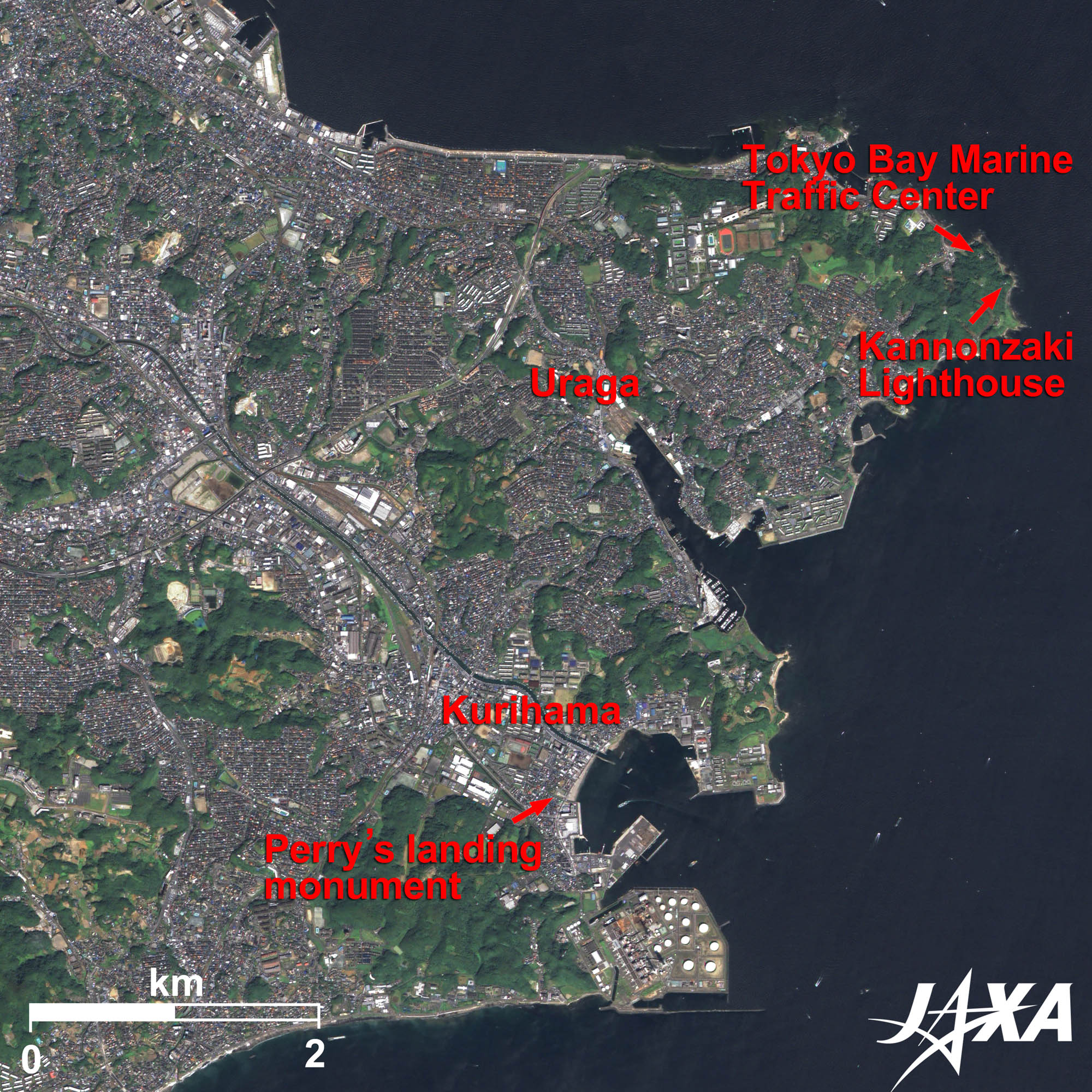 
Fig. 2. Uraga and Kurihama
Uraga and Kurihama (kmz, 4.3 MB, Low Resolution) as seen on Google Earth Figure 2 is an enlarged image of Uraga and Kurihama on the east side of the Miura Peninsula. Four ships of the U.S. East India Squadron, led by Commodore Perry, crossed the Atlantic, stoppingat Cape Town, Singapore, Hong Kong, Shanghai, Okinawa and the Ogasawara Islands, before arriving at Uraga Harbor on July 8, 1853. Perry’s arrival at Uraga surprised and confused Japan. A famous comic tanka (a style of Japanese poetry) was composed as “Awoken from the sleep of a peaceful quiet world by Jokisen tea, drinking only four cups of tea, one cannot sleep even at night,” which jokingly commemorates the landing (see Commodore Perry returned to Japan in February, 1854 and the Convention of Kanagawa was concluded. Perry’s arrival triggered the opening of Japan to the world and paved the way to the Meiji restoration. There are now a monument to the landing and a museum at Kurihama. 
A comic tanka, “Awoken from sleep of a peaceful quiet world...”“Awoken from the sleep of a peaceful quiet world by Jokisen tea, drinking only four cups of tea, one cannot sleep even at night.”
Perry’s Landing MonumentA retired midshipman from Perry’s fleet, Mr. Beardslee, later revisited Kurihama and was shocked to find that there was nothing to indicate that this was the spot of Perry’s landing. Through Beardslee’s work, a monument to commemorate Perry’s landing was constructed in 1901 by the Friends of America Association. Hirobumi Ito, Japan’s first Prime Minister, wrote the words which were inscribed upon the monument. 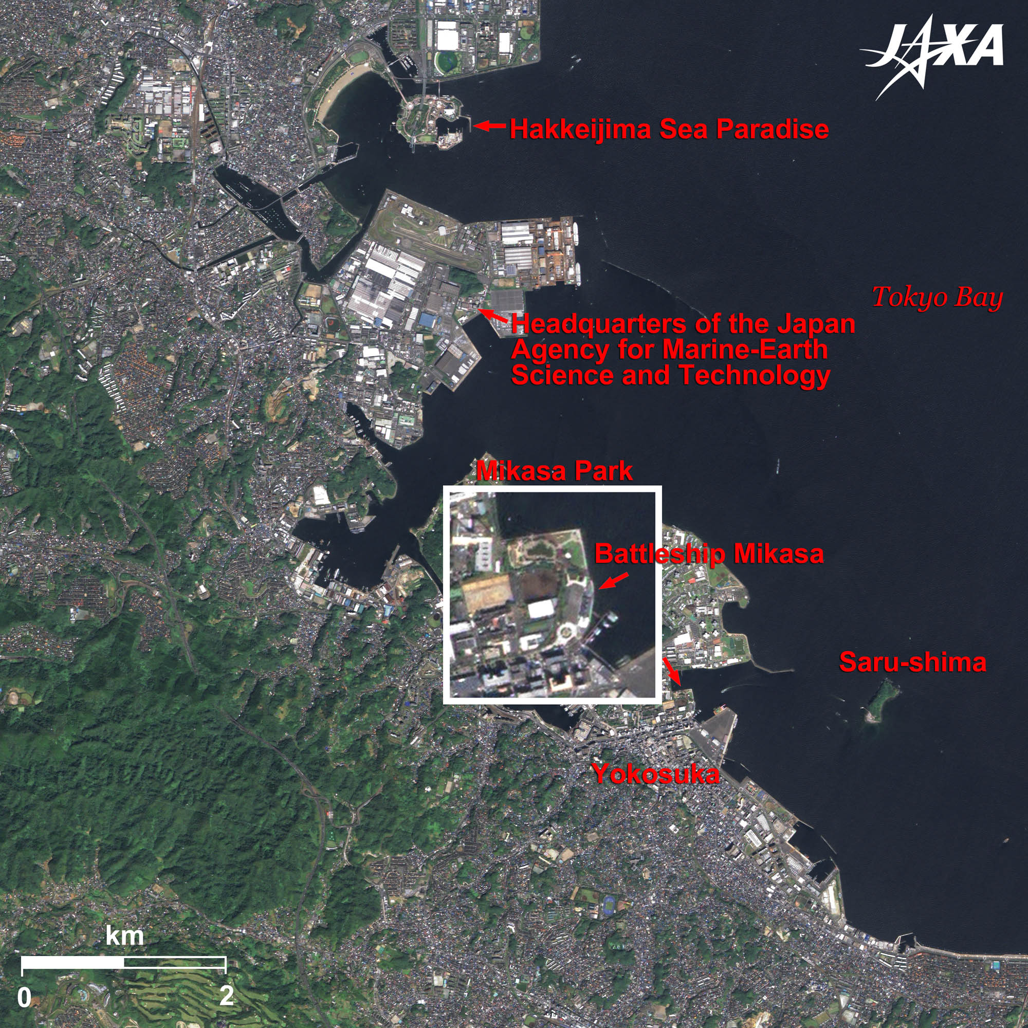 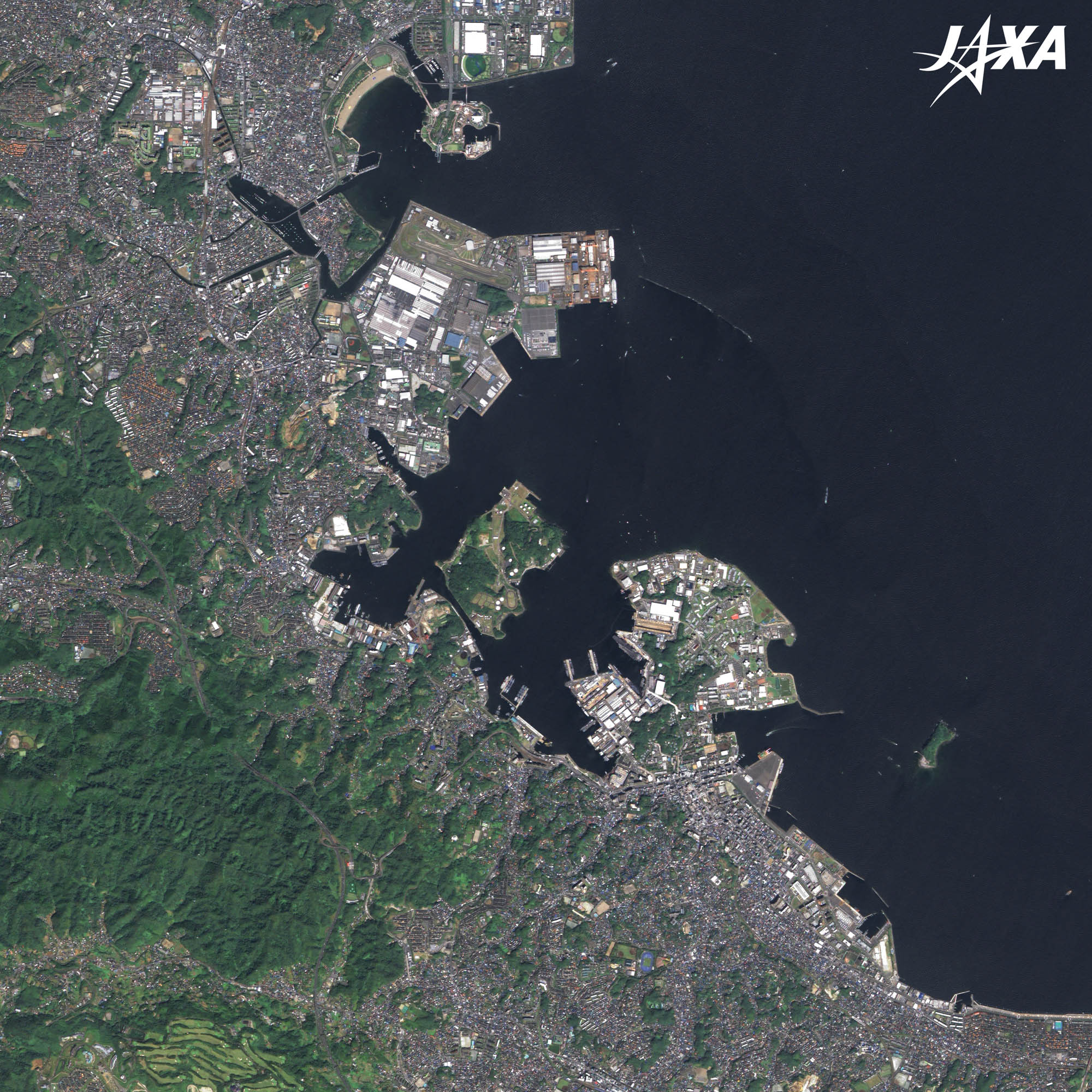
Fig. 3. Yokosuka and Its Surroundings
Figure 3 shows Yokosuka and its surroundings. Uraga and Kurihama belong to Yokosuka city. Yokosuka faces Tokyo Bay in the east and Sagami Bay in the west. The image is of central Yokohama on Tokyo Bay. Hakkeijima Sea Paradise amusement park is visible in the upper part of the image. Hakkeijima Sea Paradise is an artificial island belonging to Yokohama City.The headquarters of the Japan Agency for Marine-Earth Science and Technology is located on reclaimed land below Hakkeijima. The research center has facilities such as a high-pressure test tank and a pier where marine research vessels are moored.
Saru-shima (Monkey Island)Saru-shima was originally called “Toyo-shima” until the year 1253 when a holy Buddhist priestnamed Nichiren sailed from Chiba district to Kamakura.. His ship was damaged by a typhoon and almost sank. During the emergency, the priest chanted a prayer and a white monkey suddenly appeared and led him safely to the island. After this event, the island was called the Monkey Island. Ancient ruins have also been excavated on the island. Explanation of the Images:
AVNIR-2 has four observation bands. The color composite images are produced by assigning red to Band 3 (610 to 690 nm), green to Band 2 (520 to 600 nm) and blue to Band 1 (420 to 500 nm). The resulting images have natural coloring as if seen by the naked eye. Each color indicates the following ground objects;
PRISM is an optical sensor for observing ground surfaces with visible and near-infrared signals in the 520- to 770-nanometer (one-billionth of a meter) band. The image is monochromatic but has a higher resolution. PRISM has three independent optical systems to acquire images in the view of nadir, forward, and backward simultaneously. Only the nadir images are used in these figures. The above AVNIR-2 color composite image is decomposed into, hue, saturation, and intensity. The intensity portion is replaced by PRISM data. The hue, saturation, and intensity data are then reversed into a color image. This color image has a virtual 2.5-m resolution. A color image composed by combining a higher resolution monochromatic image and a lower resolution color image is called a pan-sharpened image. |


