Seen from Space 2008
"The Gathering Place" in the Pacific, Oahu Island, Hawaii
The Hawaiian Islands are located in the middle of the vast Pacific Ocean between Kure Atoll at latitude 28.5°N and the Island of Hawaii at 19°N. This archipelago consists of 137 islands, islets, and atolls. It extends some 2,450km in a gentle arc and represents the exposed peaks of the great undersea volcanic mountain range known as the Hawaiian-Emperor seamount chain. Magma erupted from cracks on the seabed and piled up over many years from 40 million to 25 million years ago. According to the plate tectonics theory, the chain of islands formed as the Pacific Plate moved slowly northwestward over a hotspot in the Earth's mantle at about 5 to 7.5cm per year. Oahu (Oʻahu in Hawaiian) has moved 354km westward from the place it was born.
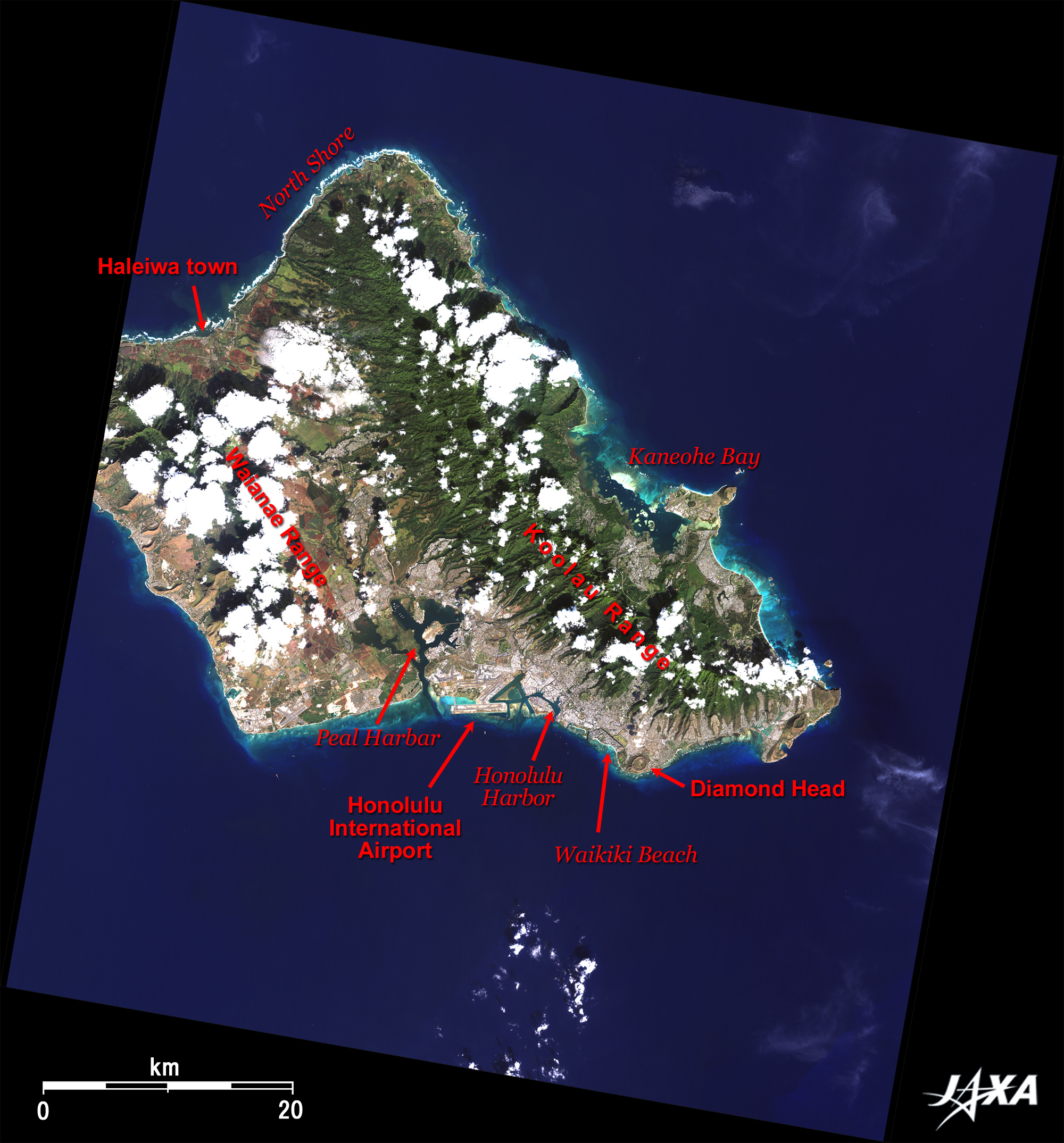
Hawaii became the 50th state of the United States in 1959. The present population of Hawaii is 1.2 million of which 75% lives in Oahu and half of them live in Honolulu. Honolulu is the state capital and the largest city in Hawaii. The administrative area of Oahu extends up to Kure Atoll 2,253 km to the northwest, including islets and atolls (except Midway), which compose Honolulu City and Honolulu territory. Accordingly, Honolulu is the 11th largest city in the United States. Whitecaps breaking on the beach are visible on the northern coast of the island. This is the famous "North Shore" where big waves, sometimes more than 15 m high, constantly crash ashore in winter, and many surfing events take place each year. The low-pressure area spawned during the Siberian winter creates big waves as it moves from Japan to the Aleutian Islands, and the waves travel all the way to the Hawaiian archipelago. Haleiwa Town in the center of the North Shore is always crowded with surfers and is where many Japanese immigrants settled and worked in the sugarcane and pineapple fields. Many shops and stores with Japanese signboards can be seen there. Japanese immigration to Hawaii began in 1868 during the Meiji Restoration, according to a treaty between the Japanese government and the former Hawaiian government. From 1885 (the year when government-promoted immigration began) to 1894 (the year when the Republic of Hawaii was proclaimed), 29,000 Japanese settled in Hawaii. Private sector immigration continued until 1900 when Hawaii became a territory of the United States. There were 35,000 emigrants at that time, representing 40% of the total population of Hawaii. Until the blanket ban of immigration in 1924, it is estimated that 61,000 Japanese emigrants crossed the sea. There are many cliffs on eastern Oahu where the Koolau Mountain Range pushes out to the sea. Easterly wet trade winds carry much rainfall to the mountain sides and create a rich flora of green vegetation. The ranch in a deep gorge in the Koolau Mountain Range, on the north of Kaneohe Bay on the east coast, is where the films "Jurassic Park" and "Godzilla" were shot.
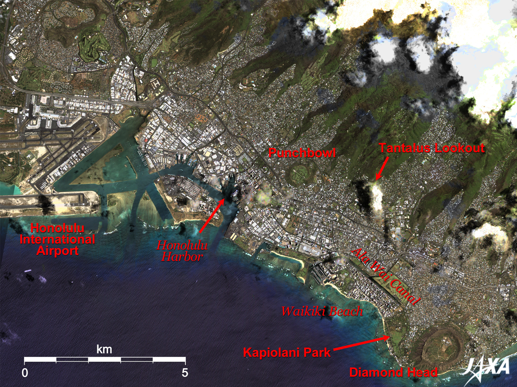
Diamond Head is a rim of a beautiful 1,200-m-diameter conical volcanic crater. Kapiolani Park, named after the beloved wife of King Kamehameha, is located on the beach on the west of Diamond Head. To its west, is Waikiki, surrounded by Ala Wai Canal and beaches.
Figs. 2. PRISM is an optical sensor for observing ground surfaces with visible and near-infrared signals in the 520 to 770 nano-meter (one-billionth of a meter) band. The acquired image is monochrome. PRISM has three independent optical systems (telescopes) to acquire images for nadir, forward, and backward views at the same time. Only the nadir image was used in this article. The above AVNIR-2 composite image was then transformed into hue, saturation and intensity, and the intensity was replaced by the PRISM image. The hue, saturation and intensity data were then reversed into a color image. As a result, a virtual 2.5-m ground-resolution color image was obtained. This kind of high-resolution color image, composed by combining the higher resolution monochrome image and the lower resolution color image, is called a pan-sharpened image.
|