| |
 |
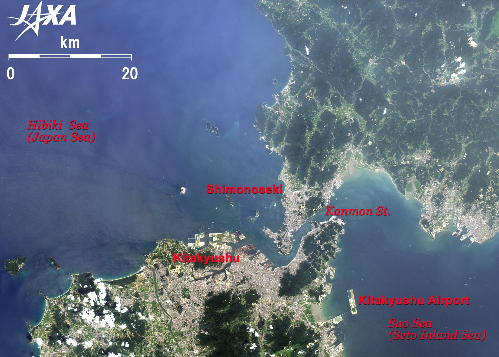
| Fig. 1 Vicinity of Kanmon Strait |
Figure 1 depicts the vicinity of Kanmon Strait as observed on August 4, 2006. On the north side of the Kanmon Strait is Shimonoseki City, Yamaguchi Prefecture, main island of Japan's westernmost city, and on the south side is Kitakyushu City, Fukuoka Prefecture, Kyushu's northernmost city. Kanmon Strait, is called "Kan" of "Seki" in Shimonoseki and "Mon" of Moji Ward in Kitakyushu City; both are Chinese style readings. On the west side of the Kanmon Strait is the Japanese Sea (Sea of Hibiki), and on the east side is the Sea of Suo in the Seto inland sea. The narrowest point of the strait is 700 m. This area has been an important strategic defense and traffic point for a long time. The old name of Shimonoseki is Dannoura. The naval battle of Dannoura in 1185 was fought by two powerful families in feudal Japan, Minamoto and Taira. The battle was fought according to the flow changes in the strait, as it changes its flow between east and west four times a day with the ebb and flow of the ocean. Now, 600 ships travel the strait each day, and many wakes are visible in the image.
An artificial island in the sea of Suo, 4,125 m long and 800 m wide, supports Kitakyushu Airport, which opened in 2006, and serves Tokyo, Okinawa, and Shanghai lines.
 |
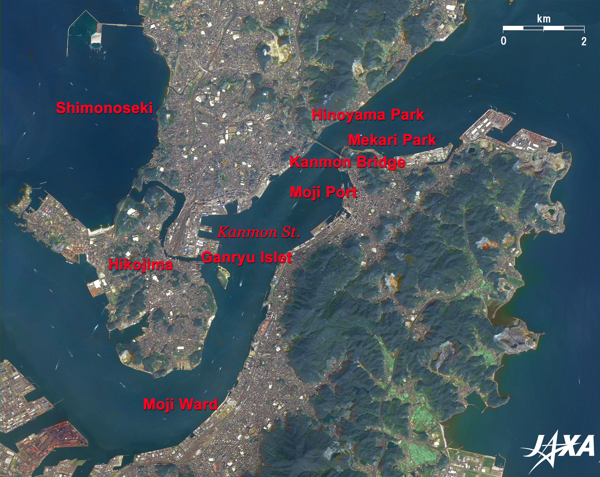
Fig. 2 Vicinity of Kanmon Bridge
Kanmon Strait (kmz, 3.82 MB, Low Resolution) as seen on Google Earth. |
Figure 2 depicts the area around the 1,068-m-long Kanmon Bridge, opened in 1973. The bridge is a part of the 9.4-km-long Kanmon Expressway that connects Chugoku Expressway and Kyushu Expressway. North of the bridge, the 3-km-long Kanmon Tunnel for vehicular and pedestrian traffic (opened in 1958) and the 17-km-long Shin-Kanmon Tunnel for the Shinkansen (opened in 1975) lie in parallel under the sea. Hinoyama Park on Shimonoseki and Mekari Park on Kitakyushu are recreation and relaxation areas for residents of both cities.
Moji Port in Moji Ward is visible south of the bridge. The city of Moji has been known for trade since the Meiji era, and the area around the port is now named Moji port historical district (Moji-ko Retro Town) because of its many cultural buildings from the Meiji and Taisho eras (1868 to 1926). Moji Port Station was built in 1914 and was a terminal point in Kyushu before the Kanmon Tunnel was opened. It is Kyushu's oldest wooden train station and is still in active service while retaining its original character.
The inhabited island 4 km south of the bridge is Funa-jima island of Shimonoseki, where famous samurais Kojiro Sasaki and Musashi Miyamoto fought a duel around 1612 (1602); it is also called Ganryu-jima.
Both Moji and Shimonoseki have been known as port towns, and industries related to the shipping industry and trading have prospered there. Hiko-jima Island south of Kanmon Strait still has active shipbuilding, heavy chemicals, and marine products industries. Hiko-jima is also known as the Taira family headquarters during the Dannoura battle.
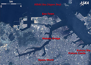 |
| Fig. 3 Southern Sea of Hibiki |
Kitakyushu City has seven administrative wards, Kokura-kita, Kokura-minami, Tobata, Moji, Yahata-nishi, Yahata-higashi, and Wakamatsu Wards, and a population of 990 thousand. Wakamatsu, Tobata, Kokura-kita and Yahata-nishi Wards are visible in Fig. 3.
Kitakyushu was home to the Yahata steel works for a long time, as well as to typical heavy chemical industries. However, the city has recently been reborn as an Eco-Town. Factories recycling home appliances, automobiles, and office appliance have aggregated there, and ecology-friendly factories are invited to build on large reclaimed land areas along the coast of Hibiki. This lush Eco-town is visible in the image.
The 627-m-long Wakato Bridge opened in 1962 and connects Tobata (West) and Wakamatsu (East) Wards. It is visible in the middle of figure and was the best bridge in the orient when it first opened. The space amusement theme park "Space World" can be seen in a triangular lot 3 km south of Wakato Bridge. The theme park is built on the site of the former Yahata steel works. Higashida, Japan's first blast furnace, began operation in 1901 and can be seen south of the theme park.
On the right side of the figure is Kokura, central Kitakyushu City and Kokura-kita Ward. The largest commerce and business districts in Kitakyushu are built around Kokura Station. Kokura Castle, where the feudal Hosokawa family once lived, is visible southwest of the station.
 |
Fig. 4 Three-Dimensional View around Kanmon Strait
(Staring at the image for a long time may cause eye strain.) |
Figure 4 is a 3-D view of the area around Kanmon Strait. If you view this figure with red and blue 3D glasses, you can distinctly see the steep mountains. Note that north is to the right in this image. You can see that both cities have wide mountainous areas and that the urban areas are near the coast. The mountainous area in Kitakyushu is the Kitakyushu Quasi- National Park.
Kitakyushu and Shimonoseki are divided by the strait, but they are an old urban area and an economic zone, and their continued promotion of interchange, cooperation and integration are expected.
Explanation of the Images:
Figs. 1 to 4 - Click the images twice to enlarge them.
AVNIR-2 has four observation bands. Figures 1, 2 and 3 are composite images produced by assigning red to Band 3 (610 to 690 nm), green to Band 2 (520 to 600 nm), and blue to Band 1 (420 to 500 nm).
PRISM is an optical sensor for observing ground surfaces with visible and near-infrared signals in the 520 to 770 nm (one nanometer (nm) is one-billionth of a meter) band. The acquired image is monochrome. PRISM has three independent optical systems (telescopes) to acquire images from nadir, forward, and backward directions at the same time. Only the nadir image was used in this article.
The AVNIR-2 composite images were transformed into hue, saturation and intensity, and the intensity was replaced by the PRISM images. The hue, saturation and intensity data were then reversed into a color image. As a result, virtual 2.5-m-ground-resolution color images were obtained. This kind of high-resolution color image, composed by combining the higher-resolution monochrome image and the lower-resolution color image, is called a pan-sharpened image. Figures 2 and 3 present high-resolution, pan-sharpened images composed this way.
The resulting images have natural coloring as if seen by the naked eye. Thus, colors indicate the following ground objects.
| Green: |
Forests |
| Light green: |
Grass or Farmland |
| Bluish grey: |
City area or roads |
| Blue: |
Water area |
Figure 4 is a 3-D image produced in cooperation with the Satellite Application Promotion Center (SAPC). Note that north is to the right in Fig. 4, but to the top in Figs. 1 to 3. |
|