| |
 |
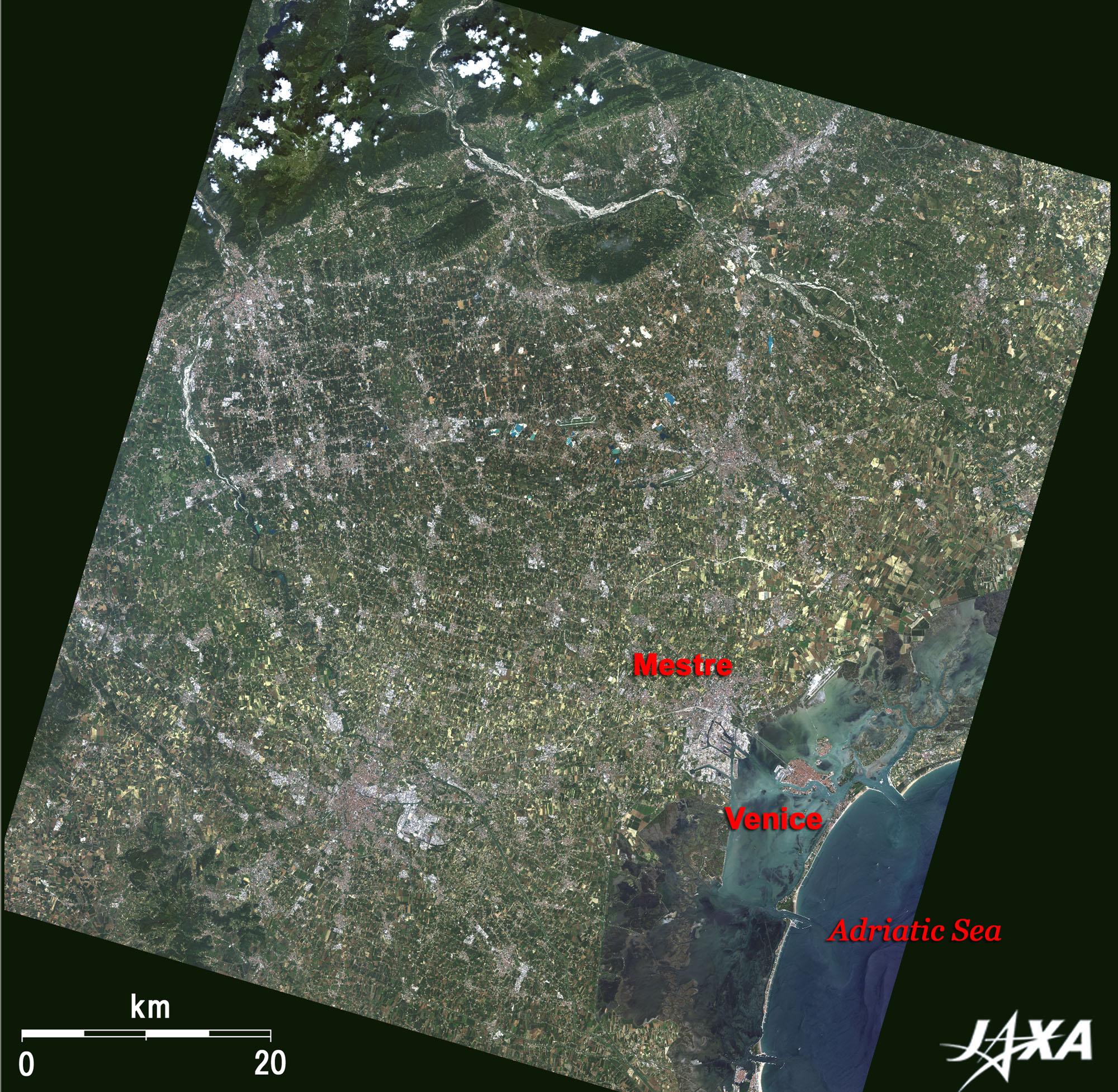
| Fig. 1 Venice and Vicinity |
Figure 1 depicts Venice (Venezia in Italian) and its vicinity in northern Italy as observed in June 2007. It is located at the eastern base of the boot-shaped Italian peninsula. The innermost Adriatic Sea is seen in the lower right, and the deep-green mountains composing the Alps range are visible in the upper left. Venice stands on a lagoon (laguna) formed earth and sand from the continent carried by the river flow and by the force of the Adriatic waves and wind. Three mouths are visible opening from the lagoon to the Adriatic Sea, and the brownish island on the west of the northernmost mouth is Venice.
 |
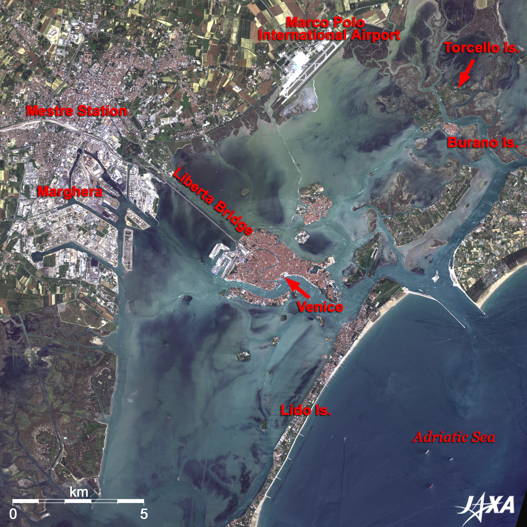
| Fig. 2 Close-up of the Vicinity of Venice |
This close-up image clearly shows the bridge connecting the continent and Venice. The railway track branches off from Mestre Station, where the Orient Express (which runs along the continental coast) once stopped, juts out into the sea, crosses the Libertà Bridge (Ponte della Libertà), and arrives at Venice in about 10 minutes. From the Marco Polo International Airport, visible in the upper part of the image, Venice can be reached by bus or by waterbus. The waterbuses sail along the dredged channel on a shallow lagoon, and their white wakes look like a road on the sea.
The Marghera Industrial Area to the south of Mestre Station looks white. This is one of the largest industrial ports in Italy. The deep-green area to the south of Marghera is the reeded lagoon. The lagoon also spreads over the east side of the airport. Trocello Island in this lagoon was the place where Venetians first settled in the 6th century. They were refugees from Roman cities who were fleeing from barbarian invasion and ran into a marshy reeded lagoon that faced the Adriatic Sea. In the early 9th century, they had to escape again to the present main island of Venice. The lagoon was a natural fort, and the people drove in countless piles, built houses and made canals using natural ditches. Venice is floating in the sea connecting 118 islands by 400 bridges and maze-like canals.
Venice was the center of the Venetian Republic that won autonomy from the Eastern Roman Empire (the Byzantine Empire) in 726. Since then, it was ruled by Doges and reigned as "A Queen of the Adriatic Sea" based on the mighty sea power and the wealth generated by commerce until it was destroyed by the Napoleon invasion in 1797. Marco Polo, a trader and explorer who gained fame for his worldwide travels, recorded in the book Il Milione ("The Million" or The Travels of Marco Polo), was born in Venice.
Horses and wagons were shut out for a long time from the Middle Ages, and transportation means were only on foot or by ship. However, the long thin Lido Island in the south, famous for the locale of Thomas Mann's novel "Der Tod in Venedig (Death in Venice)," permits cars and bicycles.
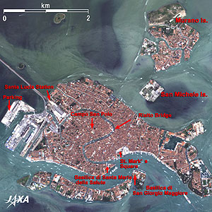 |
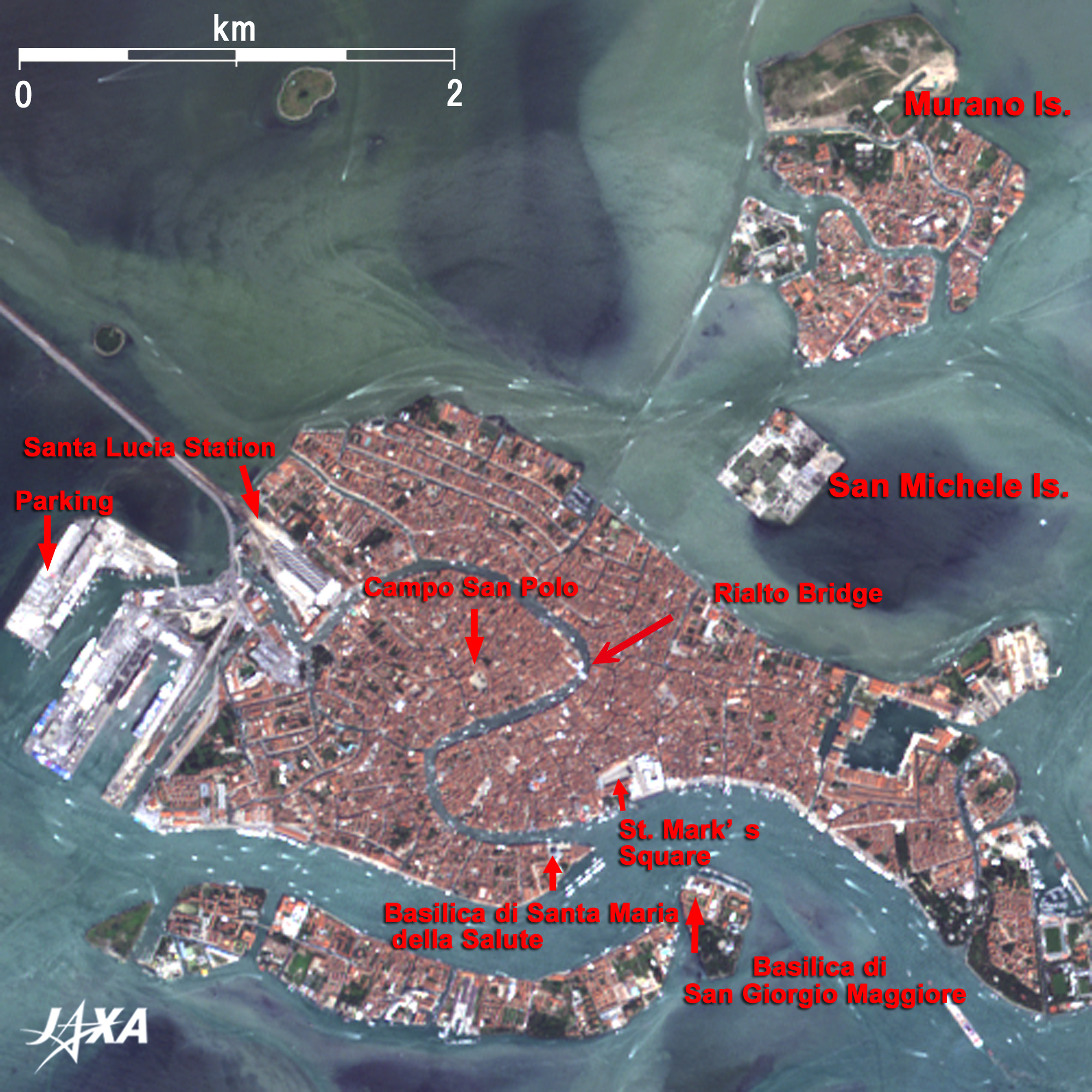
Fig. 3 Close-up of Venice
Venice (kmz, 1.44MB, Low Resolution) is seen from Google Earth. |
Figure 3 is a close-up image of the ideal man-made Venice that the people built up over 1,000 years. Libertà Bridge ends at Santa-Lucia Station. To its southwest, four large vessels were berthing in the harbor. Cars that crossed the bridge are only allowed to reach around here, and visitors have to leave their cars at the man-made parking island. Basilica of St. Mark (Basilica di San Marco), Ducal Palace (Palazzo Ducale), and adjacent St. Mark's Square (Piazza San Marco) look white at the mouth of the Grand Canal, which runs from the station like an inverted S-shape in the middle of Venice. Famous sightseeing spots such as Rialto Bridge, Campo San Polo, Basilica di Santa Maria della Salute, and Basilica di San Giorgio Maggiore are also visible in the figure. Located to the north of Venice are San Michele Island (known for its cemetery) and Murano Island (famous for Venetian glass). As the legend goes, the glass factories on the main island often caused fires and so were moved to one island, which turned out to protect traditional handicrafts.
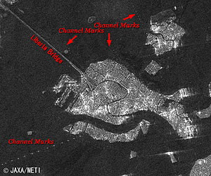 |
| Fig.4 Radar image observed by PALSAR |
Figure 4 is a radar image acquired by PALSAR in January 2007. It covers almost the same area as Fig. 3. White dotted reflections from the piers of the Libertà Bridge are seen standing in a row. The white dotted lines visible on the north of the Libertà Bridge, between Murano Island and the main island, and equally spaced white dots along the channel are the channel marks. Wakes left behind the ships indicate the water channels in Fig. 3, while the white dotted line reflected from the pilings indicate the channel marks in Fig. 4. Fortunately, there are very few sailing ships as the image was captured at nighttime.
World Heritage of the United Nations Educational, Scientific and Cultural Organization (UNESCO) has six cultural criteria and four natural criteria. Venice and its Lagoon (1987) is the only one World Heritage site that satisfied six cultural criteria.
Explanation of the Images:
(Figs.1 through 3)
AVNIR-2 has four observation bands. The composite images are produced by assigning red to Band 3 (610 to 690nm), green to Band 2 (520 to 600nm), and blue to Band 1 (420 to 500nm). The resulting image has natural coloring as if seen by the naked eye. Thus, the following colors designate ground objects.
| Dark green: |
Forests |
| Light green: |
Grass fields, farmlands |
| Bluish grey: |
City area, roads |
| Red: |
Redbrick houses |
| Blue: |
Water surfaces |
(Fig.4)
PALSAR is an active microwave sensor using L-band frequency to achieve cloud-free and day-and-night land observation. It is equipped with a radar beam pointing function across the ALOS flight direction and a ScanSAR function to provide a much wider area of observation. |
 |
|