Seen from Space 2007
The World's Great Falls (Part 1) Iridescent Niagara Falls between USA and Canada
| |
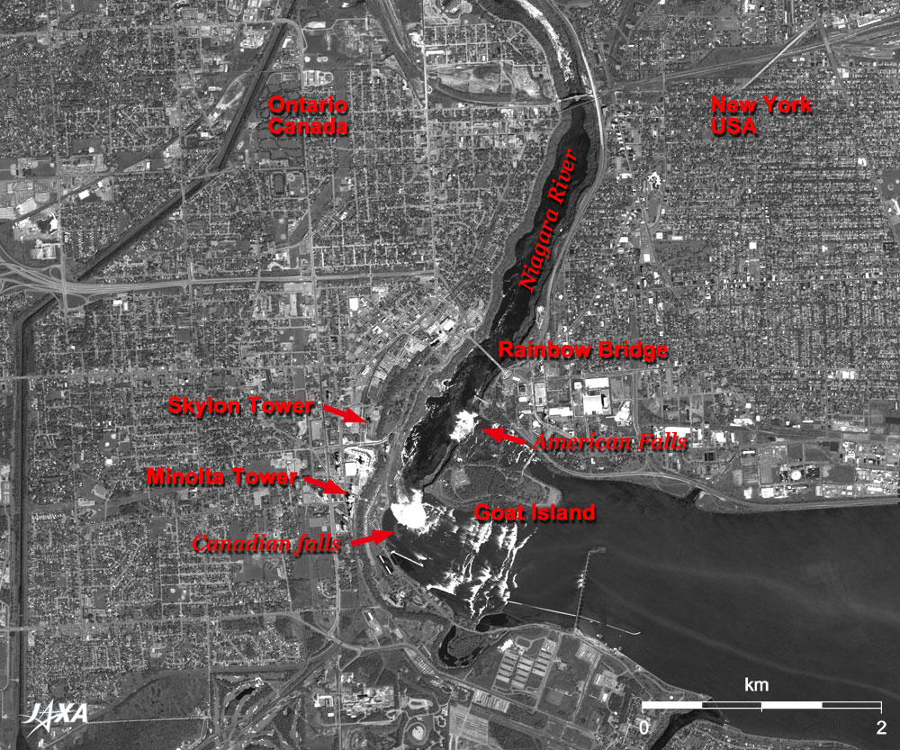
Figure 1 depicts the vicinity of Niagara Falls as observed by the Panchromatic Remote-sensing Instrument for Stereo Mapping (PRISM) on board the Advanced Land Observing Satellite (ALOS) "Daichi" in June 2006. This waterfall presents different faces with seasonal beauty throughout the year. It is lit up at night, which creates a grand illusion of natural and artificial rainbows. The Niagara River, flowing from the lower right (southeast) to the top (north) of the figure, connects Lake Erie and Lake Ontario. The two big white waterfalls visible on either side of Goat Island are located on the border between the United States and Canada. They are called the Horseshoe Falls (Canadian Falls) and the American Falls.
The name "Niagara" originates from a Native American (Iroquois) word "Onguiaahra" meaning "Thunder of Waters." This massive waterfall, which is 670m wide and drops 54m, is one of the world's three major waterfalls. It was formed on an escarpment carved by glaciers about 12,000 years ago. The original waterfalls were located 13km downstream, but erosion has caused the waterfalls to retreat to the present location. Erosion and recession are still continuing.
Tourism has been popular in this area since the 1820s, and today more than 15 million tourists visit every year. The 300m-long steel Rainbow Bridge linking the United States and Canada is visible in the center of the figure. The plate, the United Nation's flag, and the national flags of both countries are put up at the border or the center of the bridge. The 160m-high Skylon Tower and 99m-high (Konica) Minolta Tower, located on the left (west) of the Canadian Falls, command an extensive prospect of the waterfall.
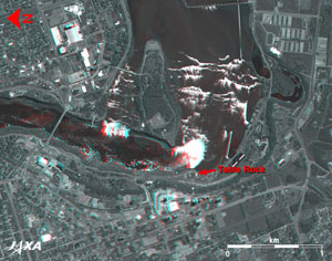 |
Fig. 2 Three-Dimensional View of the Niagara Falls and its Vicinity (North is to the left.)
(Staring at the image for a long time may cause eye-strain. A color print is available in pdf format. Pdf files for the left and right eyes are also available for stereoscopic viewing.) |
Figure 2 is a 3-D view combining two (forward- and nadir-looking) of the three directional images captured by PRISM. Water surface levels in the upstream (the top of the figure) and the downstream (left of the figure) look different. The level difference between the Table Rock beside Canadian Falls and the resort facilities with two towers is also apparent.
The Welland Canal is located on the west of the Niagara River. It is a 43.4km canal regulating the 99.5m water level difference with eight locks. It connects Lake Erie and Lake Ontario, passes around Niagara Falls, carries 40 million tons of cargo each year, and supplies industrial water and a limited amount of water for power generation.
Explanation of the Images:
(Figs. 1 and 2)
The nadir image is used in Fig.1; and the forward image (red) and nadir image (green and blue) are used in Fig. 2.
|
 |
|