Seen from Space 2007
Beijing in the Long History of China
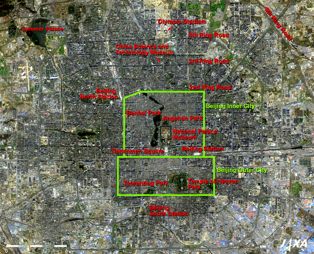
The upper green frame in the center of the figure (the north edge is the north side of Beihai Park and the south edge is the large avenue running east and west in front of Zhengyang Gate on the south of Tiananmen Square) is the site of the Ming and Qing Dynasties Beijing Inner City. The lower green frame indicates the site of the Beijing Outer City surrounded by three river moats on the south, east and west. The Temple of Heaven and four other large parks are visible in the Outer City. The Beijing Station with the white roofed railway platforms is located at the southeast corner of the old Inner City. Beijing North Station is just outside of the northwest corner of the Inner City, and Beijing South Station is at the south of the moat beside Taoranting Park in the old Outer City. The Beijing Inner City wall was mostly torn down to make way for the construction of the 2nd Ring Road, and the Outer City wall was also replaced by local roads. The 3rd Ring Road, the 4th Ring Road, and the 5th Ring Road are visible outside the 2nd Ring Road. A white cylindrical building and the round dome of the China Science and Technology Museum are visible along the 3rd Ring Road to the north of the National Palace Museum. Models of spaceships and artificial satellites are displayed here. The ocher bare ground visible to the north of the 4th Ring Road is the main venue of the 2008 Beijing Olympic Games (the Olympic Green). The Olympic Stadium and other sports arenas under construction are visible. The Summer Palace (Yuheyuan) is visible in the northwest corner of the figure. This is a 290ha typical Chinese garden consisting of Longevity Hill and Kunming Lake. This was a detached palace of the Qing Dynasty that the Qianlong Emperor took 15 years to construct beginning in 1750. Mountains and lakes in this garden are all man-made. It was burned in 1860 by the English-French allied forces during the Second Opium War (Anglo-Chinese War). The West Empress Dowager, who became the actual ruler of the Qing Empire after that, planned to reconstruct it with large modifications, as her private summer resort to celebrate her sixtieth birthday, and named it Yuheyuan. Thus it is called the "Summer Palace." It is now open to citizens as a park owned by the Beijing government. The National Palace Museum, the Summer Palace and the Temple of Heaven were added to the World Cultural Heritage list of the United Nations Educational, Scientific and Cultural Organization (UNESCO) as follows. Three airports are visible in the full image, to the southeast, to the south and to the northwest of Beijing, but the Beijing Capital International Airport is outside the image as it is 25 km northeast from the city center.
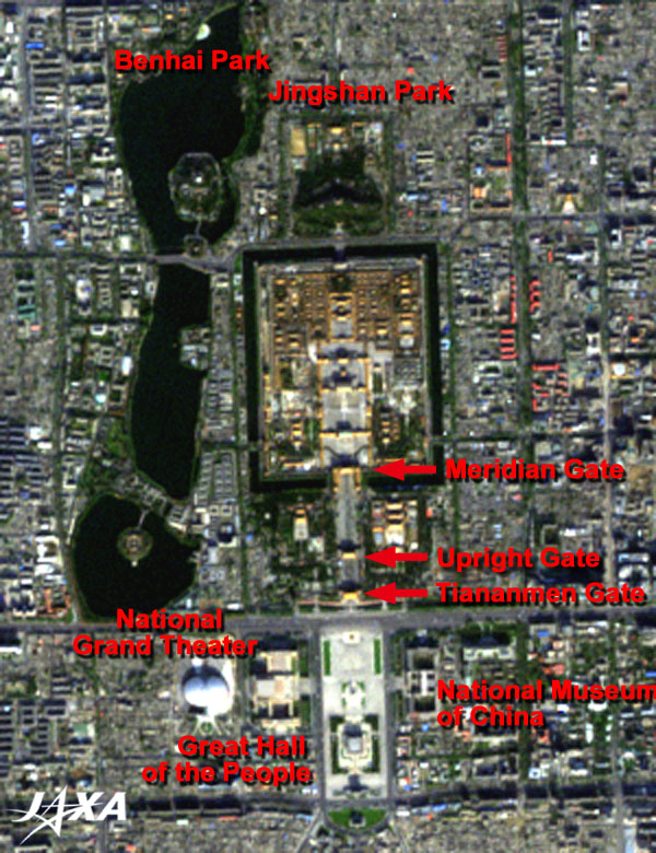
The Forbidden City has been a symbol of absolute sovereignty for 500 years since its construction in 1420 as a palace of the Ming Dynasty, continuing to the Qing Dynasty, until the end in the Xinhai Revolution (1911). It is a vast castle 753 m wide east-to-west and 961m long north-to-south, enclosed by 10 m-high walls and 52m-wide moats. There are more than 50 large buildings and 9,000 ancillary buildings including pavilions in the castle. The City covers 720,000 m2 and can hold 15 Tokyo Domes. Since 1925, the Forbidden City has been open to the public as the National Palace Museum. In a passing remark, there are other National Palace Museums in Shenyang and Taipei. A typical sightseeing route starts from the Tiananmen Gate, passes through the Upright Gate, and reaches the Meridian Gate, i.e. the main entrance gate of the Forbidden City. Within the City, the Gate of Supreme Harmony, the Hall of Supreme Harmony, the Hall of Medium Harmony, the Hall of Preserving Harmony, the Gate of Heavenly Purity, the Palace of Heavenly Purity, the Hall of Earthly Peace, the Gate of Earthly Peace, and the Gate of Divine Might are visible. Tiananmen Square in the south of the National Palace Museum is 400,000 m2 in area, one of the largest open spaces of the world, and can accommodate 500,000 people. The national flag stand, the Monument to the People's Heroes, the Chairman Mao Memorial, and the Zhengyang Gate are visible in the figure. The National Museum of China is located on the east of the square, and the Great Hall of the People is located on the west. The huge white dome to the west of the Great Hall of the People is the National Grand Theater that includes an opera house, a concert hall, and a traditional performing arts theater. It will open in July 2007.
|