| |
 |
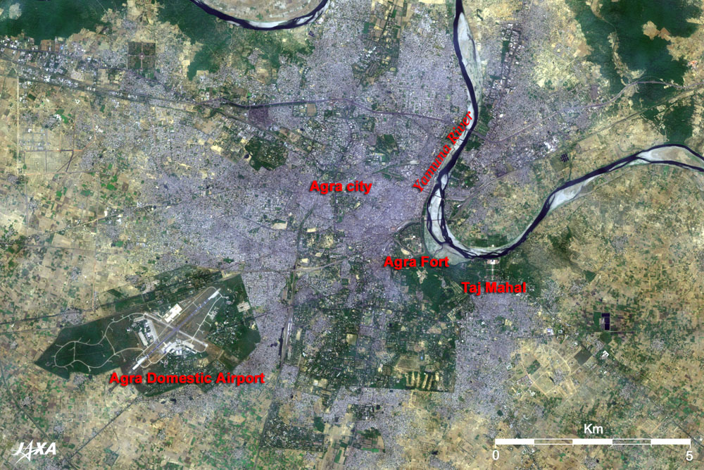
Fig. 1 Agra and its Vicinity
Taj Mahal (kmz,1.62MB,Low Resolution) is seen from Google Earth.
(Full Image) |
Figure 1 depicts the vicinity around the Taj Mahal in northern India as observed by the Advanced Visible and Near Infrared Radiometer-2 (AVNIR-2) on board the Advanced Land Observing Satellite (ALOS) "Daichi" in October 2006. The Yamuna River meandering from the top to the right of the figure is the largest branch of the Ganges River, one of the great rivers in India that originate in the Himalayas. Water seems to be low after the rainy season, and several ash-grey sandbars appear here and there. The grey urban area that spreads out on the west bank of the river is the middle-sized city, Agra, with a population of 1.32 million, located 200km south of the capital Delhi. It is famous as the old capital of the Mughal Empire (1526-1857) and is the greatest tourist destination in India because of its many splendid Mughal-era (16th century) buildings.
The Taj Mahal is an orderly shaped square building south of the Yamuna River where it makes a big bend. The triangular green area with some red dots on the west of the river is Agra Fort (Red Fort). Agra Fort was built in the 16th century by the third Mughal Emperor Akbar the Great. The castellated wall stands 20m high and is 2.5km in circumference. It is also known as "Fort Rouge" or "Red Fort of Agra" because the wall was constructed of red sandstone. The brightly shining white building in the Fort is the inner courtyard of the White Mosque (Moti Masjid) built by the fifth Emperor, Shah Jahan. The Agra Domestic Airport's runways can be seen on the left of the figure.
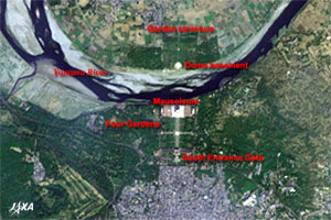 |
| Fig. 2 Close-up of Taj Mahal |
Figure 2 presents a close-up of the Taj Mahal. The Taj Mahal was built by Shah Jahan as a mausoleum to mourn for his favorite wife who died suddenly at age 38. It was completed in 1653 after 22 years of construction. It is comprised of a symmetrically arranged 65m tall white marble circular dome, 42m tall minarets at the four corners, four gardens divided by crisscrossed water corridors, and a south entrance gate. The grandeur of this mausoleum can be clearly sensed from space 700km above it. A dome basement and a garden structure are also visible on the opposite side of the river. They are the remnants of a colossal plan to construct another mausoleum but colored black, in contrast to white, and to connect the two mausoleums with a bridge over the Yamuna River. Legend has it that Shah Jahan was confined in Agra Fort after being charged with extravagance in constructing the mausoleum and spent his last seven years gazing through the window at the Taj Mahal over the Yamuna River.
Those relics were built when European countries founded the East India Companies and carried on a prosperous spice trade. (This period corresponds to the time around the Battle of Sekigahara (1600), popularly known as the Realm Divide, in Japanese history.) The architectural style, therefore, reflects the influences of the "Age of Geographical Discovery" such as Islamic culture from Persia, baroque culture from Europe, and Indian indigenous Hindu culture. These combinations created enigmatic beauties. The Taj Mahal was added to the list of the World Cultural Heritage sites of the United Nations Educational, Scientific and Cultural Organization (UNESCO) in 1983 as one of the universally admired masterpieces of the world's heritage. However, these buildings have suffered seriously from air pollution and acid rain in recent years, and the Indian Government is actively pursuing protection and restoration projects through international cooperation.
Explanation of the Images:
(Fig. 1 and Fig. 2)
AVNIR-2 has four observation bands. The composite image is usually produced by assigning red to Band 3 (610 to 690nm), green to Band 2 (520 to 600nm), and blue to Band 1 (420 to 500nm). The resulting image has natural coloring as if seen by the naked eye. In the above figures, green is assigned to the sum of 90% of Band 2 and 10% of Band 4 (760 to 890nm), which improves the visibility of vegetation. Thus the ground objects are distinguished by the following colors.
| Deep green: |
Forests |
| Green: |
Grass fields or farms |
| Khaki: |
Grass fields, farms or exposed soil |
| Bluish grey: |
City area or roads |
| Dark blue: |
Water surfaces (lakes, ponds or rivers) |
| Black: |
Areas with no data |
|
 |
|