| |
 |
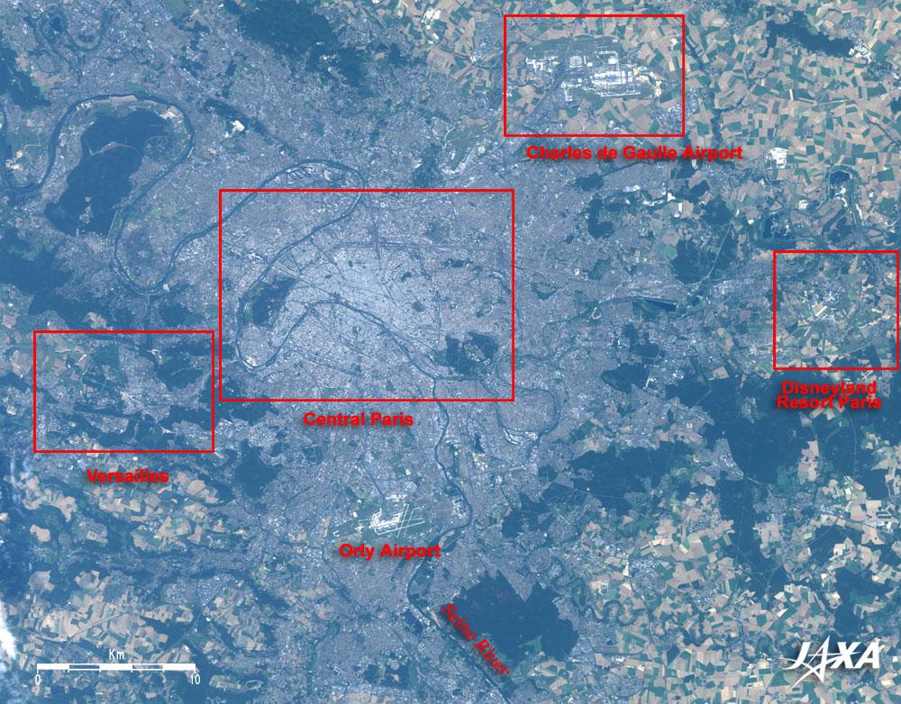
Fig. 1. Paris and Vicinity
Paris (kmz, 1.35MB, Low Resolution) as seen on Google Earth.
|
Figure 1 depicts Paris, the capital of France, as observed by the Advanced Visible and Near Infrared Radiometer-2 (AVNIR-2) on board the Advanced land Observing Satellite (ALOS) "Daichi" in September 2006. The gray area at the center of the figure is the center of Paris. The Seine River flows from the lower right to the left and meanders through central Paris. You can see that the dark green forests, and the green and hazel farmland and grassland spread to the suburbs of Paris. The huge Charles de Gaulle Airport is in the upper right of the figure, the Disneyland Resort Paris on the right, the Orly Airport at the bottom, and Versailles on the left.
 |
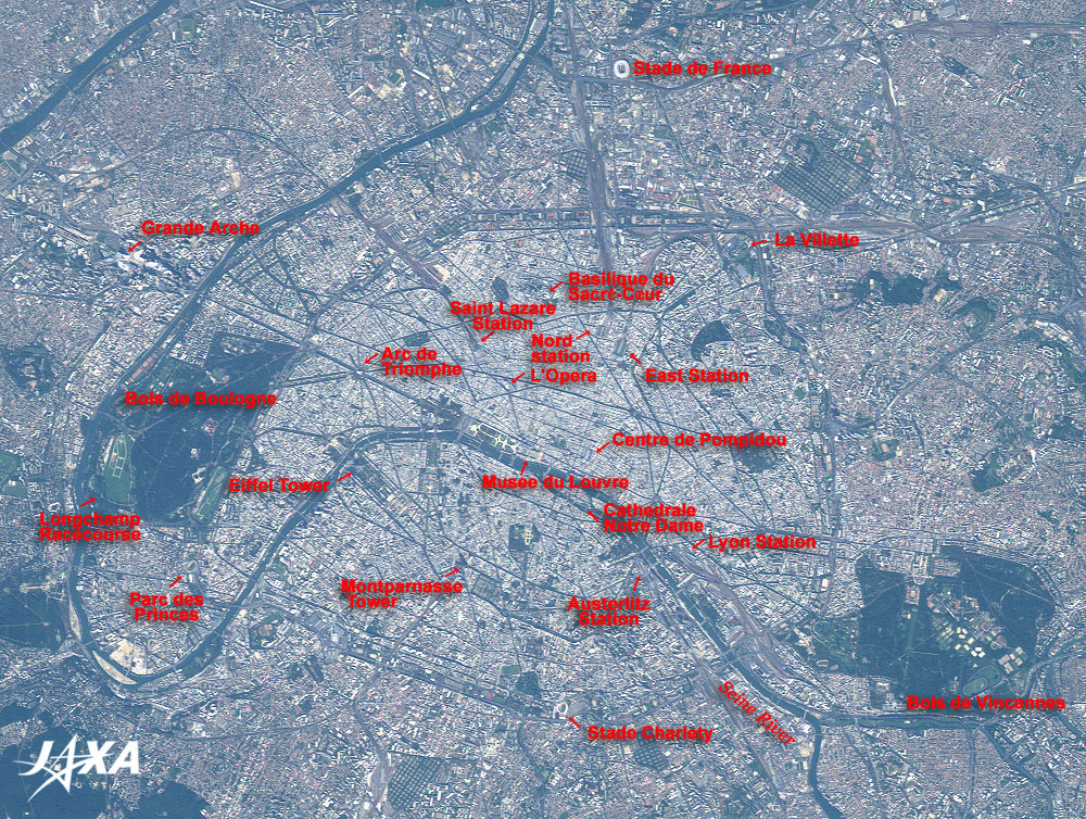
| Fig. 2. Expanded Image of Paris |
Figure 2 is an expanded image of Paris. The Seine River flows from the lower right to the center of the figure and then meanders. The dark green Bois de Boulogne (Forest of Boulogne) is visible on the left and the Bois de Vincennes in the lower right. Bordering these forests is the 35km belt highway Périférique circling the City of Paris. It appears double in most places, but the outer lane is the expressway and the inner lane is the general road. The roads in the inner city of Paris are clearly visible and appear as black lines because the heights of the buildings there are uniformly limited to several stories. Also visible are the dark green parks and cemeteries scattered about.
Inside the circular road are many historic sites. The Musée du Louvre, the magnificent palace, at the center of the figure was modified from the 16th century to the 19th century based on the fort built at the end of the 12th century. It was made public in 1793 after the French Revolution. To the lower right of the museum is the Cathedrale Notre Dame with two steeples, completed in the middle of the 14th century. The western steeple is a little higher at 69m. On the sandbank, is the Île de la Cité (Island of the City) on the Seine River.
West-northwest of the museum is the Place de l'Étoile (Plaza of the Stars) from which twelve avenues including l'Avenue des Champs-Elysees extend radially. In the plaza is the Arc de Triomphe (Arch of Triumph) that Napoleon (1769-1821) had constructed to commemorate the French victory over the Allied Forces in Germany, Austria, Russia, and Italy in 1805. The Eiffel Tower (present height is 324m) lies to the south of the arch. It was constructed in 1889 for the Paris Expo, which was opened to commemorate the 100th anniversary of the French Revolution.
The "Paris, Banks of the Seine" area that includes the Musée du Louvre, the Cathédrale Notre-Dame de Paris, the Arc de Triomphe, and the Eiffel Tower was added to the list of World Cultural Heritage Sites of the United Nations Educational Scientific and Cultural Organization (UNESCO) in 1991.
North of the museum, is the Theatre National de l'Opera, completed in 1875 by order of Napoleon III (1808-1873), and the Basilique du SacrECœur (Basilica of the Sacred Heart), which was built on the hill in Montmartre and can be clearly viewed from the city. East of the museum is the Centre national d'art et de culture Georges-Pompidou that opened in 1977 and contains the Musée National d'Art Moderne. The Montparnasse Tower, 209m high and 59 storeys, was completed in 1972 and can be seen in the south.
Paris has six railway terminals that link each area of France and Europe. Northeast of the Musée du Louvre is the Saint Lazare station, painted by the impressionistic painter Monet. Clockwise from there is the Nord (North) station, the terminal for the Eurostar that travels to and from London. The East Station is the terminal for the Orient Express. The Lyon station is the terminal for the TGV and other trains heading for southern France. The Austerlitz station is the terminal for night trains heading for Spain, and the Montparnasse station, south of Montparnasse Tower, is another TGV terminal.
In 1989, the redevelopment project "Grand Project" was initiated in Paris to celebrate the 200th anniversary of the French Revolution. The City of Science and Industry, La Villette, was developed as part of the project and is visible in the upper right of the figure. La Défense, with its conspicuous skyscrapers, contains the Grande Arche (the big arch) and was built on the extension of the Champs-Élysées Avenue. It is visible in the suburbs on the left of the figure.
The Stade de France, which was constructed as the main venue of the 1998 FIFA World Cup held in France and can accommodate an audience of 80,000, is visible at the top of the figure. The Longchamp Racecourse, where the horserace Prix de l'Arc de Triomphe (Prize of the Arch of Triumph) is run annually on the first Sunday of October, can be seen in the southwest part of the Forest of Boulogne. South of the Forest is the Parc des Princes, home stadium of Paris St.-Germain, a team in the French professional football league "Ligue 1." It can accommodate over 48,000. At the bottom of the figure, is Stade Charlety, a multi-use stadium with a capacity of 20,000.
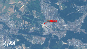 |
| Fig. 3. Expanded image of Versailles |
Figure 3 is an expanded image of Versailles. The Château de Versailles (Palace of Versailles) can be seen shining brightly in the center of the figure; the garden extends to the west of it. At the end of the gardens is a network of interconnecting green canals forming cross patterns surrounded by the forests. The rows of trees extending radially along three avenues east of the palace appear as dark green stripes. The Palace was built in the first part of the 17th century by order of Louis XIII (1601-1643) and originated as a hunting castle. During the second half of the 17th century and the beginning of the 18th century, Louis XIV (The Sun King, 1638-1715) ordered an extensive expansion project to be carried out, making it into a luxurious palace. It was used as the residence palace for Louis XIV to Louis XVI (1754-1793). It was the center of public administration in France for over 100 years until the French Revolution (1789) broke out. The "Palace and Park of Versailles" was added to the list of the World Cultural Heritage Sites in 1979.
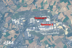 |
| Fig. 4. Expanded Image of Charles de Gaulle Airport |
Figure 4 is an expanded image of the Charles de Gaulle Airport, which opened in March 1974. The building at the center of the figure is Charles de Gaulle 1 (terminal 1), and looks like an orange cut into round slices. The rectangular building to the lower right of terminal 1 is Charles de Gaulle 2 (terminal 2). The runways and the taxiways are visible to the north and south sides of these terminals. The airport is in a farmland area.
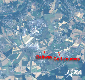 |
| Fig. 5. Expanded Image of Disneyland Resort Paris |
Figure 5 is an expanded image of the Disneyland Resort Paris. It was called Euro Disneyland and opened in 1992 in the suburbs east of Paris. You can see the ring road, approximately 3.2 km in diameter, and the main facilities located on the north side within this ring, with golf courses on its southeastern side.
Explanation of the Images:
(Figs. 1 to 5)
AVNIR-2 is equipped with a pointing function by which it can shift its observation area perpendicular to the ALOS's moving direction, and it can observe ground surfaces with four spectral bands.
AVNIR-2 has four observation bands. The composite image is usually produced by assigning red to Band 3 (610 to 690nm), green to Band 2 (520 to 600nm), and blue to Band 1 (420 to 500nm). The resulting image has natural coloring as if seen by the naked eye. Thus the ground objects are distinguished by the following colors.
| Deep green: |
Forests |
| Green or khaki: |
Grass fields, farms |
| Grey: |
City area |
| Black: |
Roads |
| Red, blue, White: |
Roofs |
| Green, dark blue: |
Water surfaces (rivers, canals) |
|
 |
|