| |
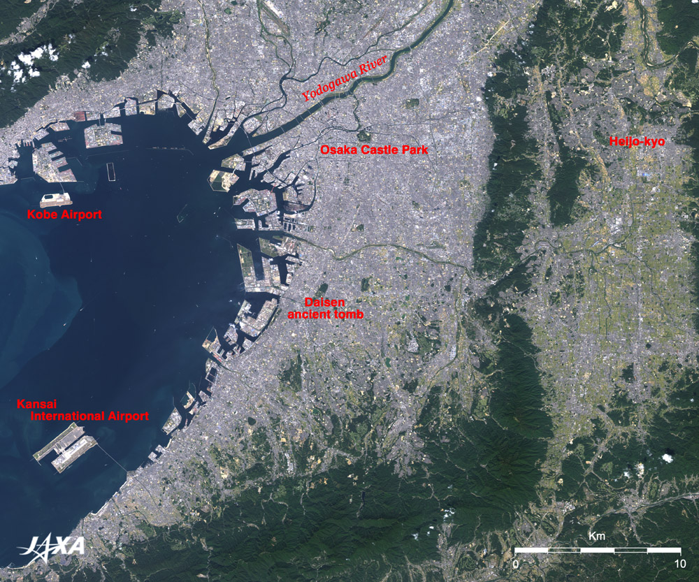
Figure 1 depicts Osaka and its vicinity as observed by the Advanced Visible and Near Infrared Radiometer-2 (AVNIR-2) on board the Advanced Land Observing Satellite (ALOS) "Daichi" in October 2006. Two offshore airports are located in the dark-blue Osaka Bay. The two large man-made islands off the coast of Senshu, in the lower left of the figure, comprise the Kansai International Airport, commonly called "Kanku." The airport was opened in September 1994, and the second airport island is now under construction. It will be restructured in 2007 as a huge 1,055ha airport with two 4,000m class runways. The offshore airport, which is visible from Port Island in Kobe, in the upper left of the figure, is the Kobe Airport (about 270ha) that just opened in February 2006. A 2,500m runway is clearly visible. Since most of the population and the main economic activities are concentrated in the waterfront areas in Japan, construction of convenient offshore airports has become rather common in recent years.
The grey city area in the central part of the figure is the Plain of Osaka. Green tracts of land dot the Plain like oases in the desert. The bullet-shaped green area in the center of the figure is the world's largest "Daisen-Kofun" or ancient tomb, i.e. the largest and longest keyhole-shaped mound in Japan. The Imperial Household Agency is taking care of the tomb as the burial site of Emperor Nintoku Mausolea. A recent investigation, however, indicates that this tomb was constructed in the 5th century, and so it is not really clear which great king is actually buried here. It is a 486m long vast Mausoleum, covering 47ha including triple moats. It is one of the three largest mausoleums in the world along with the First Qin Emperor's Mausoleum and the Great Pyramid of Khufu. It symbolizes the period of ancient burial mounds around the 5th century when the Yamato family extended rule over the Japanese Islands and engaged in international politics in the East Asia.
The green area surrounded by the moat near Yodogawa River is Osaka Castle Park. It is a large (107ha) park including historic Osaka Castle, which was constructed in the 16th century. It is not only loved by citizens as an urban oasis but is also popular to tourists as a place to overlook Osaka Plain.
The light green diamond-shaped area at the right of the figure is the Nara Basin. Nara is where the ancient city Heijo-kyo was built and where an ancient nation based on the Ritsuryo law system was established at the beginning of the 8th century. The faint brownish area at the northernmost point of the basin is where Heijo-kyo was located; archeological excavation and restoration are still under way there. Nara and many temples were added to the list of World Heritage of the United Nations Educational, Scientific and Cultural Organization (UNESCO) as "Historic Monuments of Ancient Nara" in 1998. "The Buddhism buildings of the Horyuji Temple area" in the village in Ikaruga are the oldest Asuka-style wooden structures in the world and had been added to the list in 1993.
The keyhole-shaped mound created in the 5th century, Heijo-kyo constructed in the 8th century, Osaka Castle established in the 16th century, and the offshore airport built in the 20th century represent a sequence of construction extending from an ancient times to the present day. These structures are co-located in the same figure observed from the space 700km above and directly show the stratification of history carved on the ground. Osaka is a town with culture and historical charm, and original messages from Osaka are expected to be sent worldwide from the window of "Kanku."
Explanation of the Image:
| Satellite: |
Advanced Land-Observing Satellite (ALOS) (Daichi) |
| Sensor: |
Advanced Visible Near-Infrared Radiometer type-2 (AVNIR-2) |
| Date: |
1027 (JST) on October 9, 2006 |
| Ground resolution |
10 m |
| Map Projection: |
Universal Transversal Mercator (UTM) |
|
AVNIR-2 has four observation bands. The composite image is usually produced by assigning red to Band 3 (610 to 690nm), green to Band 2 (520 to 600nm), and blue to Band 1 (420 to 500nm). The resulting image has natural coloring as if seen by the naked eye. Thus the ground objects are distinguished by the following colors. |
| Deep green: |
Forests |
| Green or khaki: |
Grass fields, farms |
| Bluish grey: |
City area or roads |
| Red, blue, white etc.: |
Roofs of buildings |
| Dark blue: |
Water surfaces (sea, lakes, rivers) |
|
 |
|