| |
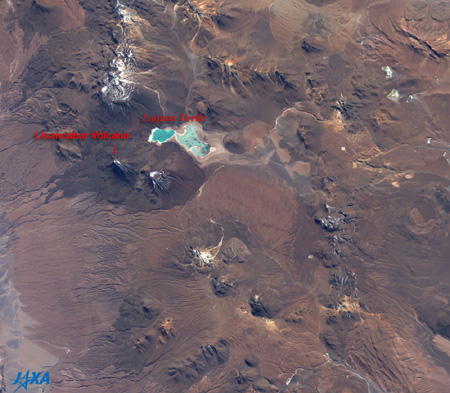 |
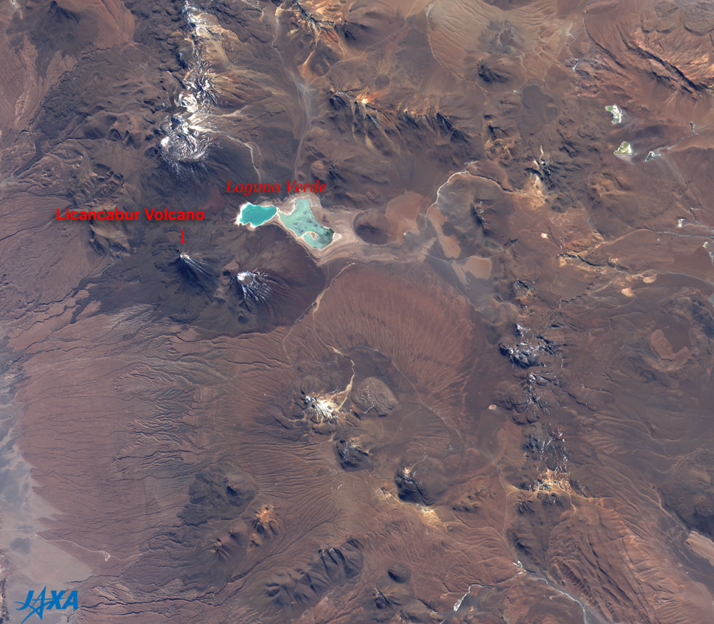
Fig. 1 Atacama Plateau observed by AVNIR-2
Atacama Plateau (kmz, 0.97MB, Low Resolution) as seen on Google Earth.
|
Figure 1 depicts the Atacama Plateau including the border between Chile and Bolivia in South America as observed by the Advanced Visible and Near-Infrared Radiometer 2 (AVNIR-2) aboard the Advanced Land Observing Satellite (ALOS) "Daichi" in May 2006. Licancabur Volcano (5,916 m above sea level) is on the left of the figure, and Laguna Verde (green lake) can be seen northeast of the volcano. The lake looks light blue in the figure. The area is very dry because the whole figure looks brown or dark brown indicating that rocks and soil are exposed without any vegetation. The white areas are snow or dried salt soil. There are many dark-brown lava formations, cone-shaped landforms, and craters, indicating past active volcanism.
 |
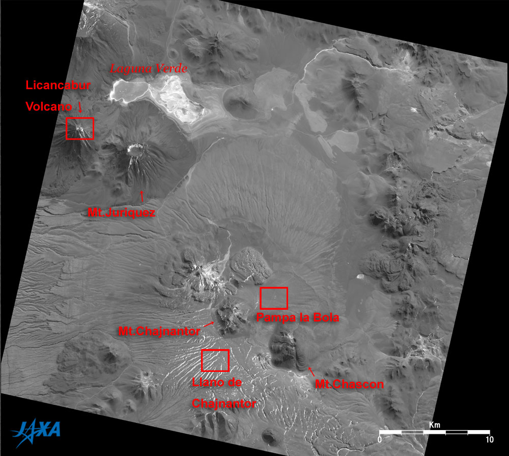
| Fig. 2 Atacama Plateau observed by PRISM |
Figure 2 depicts the Atacama Plateau as observed by the Panchromatic Remote-sensing Instrument for Stereo Mapping (PRISM) aboard the Advanced Land Observing Satellite (ALOS) "Daichi" in July 2006. Figure 2 is a monochrome imag e corresponding to the central area of Fig. 1 but depicting more detail. The Licancabur Volcano and Mt. Juriquez (5,704 m above sea level) with a big crater can be seen on the left of the figure. The eastern half of Laguna Verde north of the mountains seems to be parched. Mt. Chascon (5,698 m above sea level) and Mt. Chajnantor (5,604 m above sea level) are visible at the bottom of the figure. The highland "Pampa la Bola," about 4,800 m above sea level, is north of Mt. Chascon, and the highland "Llano de Chajnantor," about 5,000 m above sea level, is west of it.
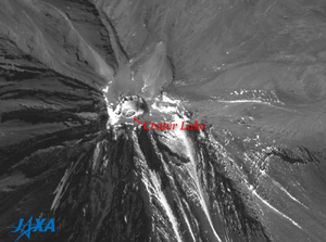 |
| Fig. 3 Expanded image around the crater on Licancabur Volcano |
Figure 3 is an expanded image around the crater on Licancabur Volcano in Fig. 2. There is a 70m by 90m crater lake within the crater, and it seems to be frozen over. This lake is located about 100m below the summit rim, so it is considered the highest lake in the world. The environment of this lake is thought to be analogous to lakes on ancient Mars because the atmospheric pressure, the temperature and the oxygen concentration are low and ultraviolet radiation is strong here. A group of researcher from NASA's Ames Research Center therefore investigated the lake in 2003.
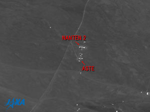 |
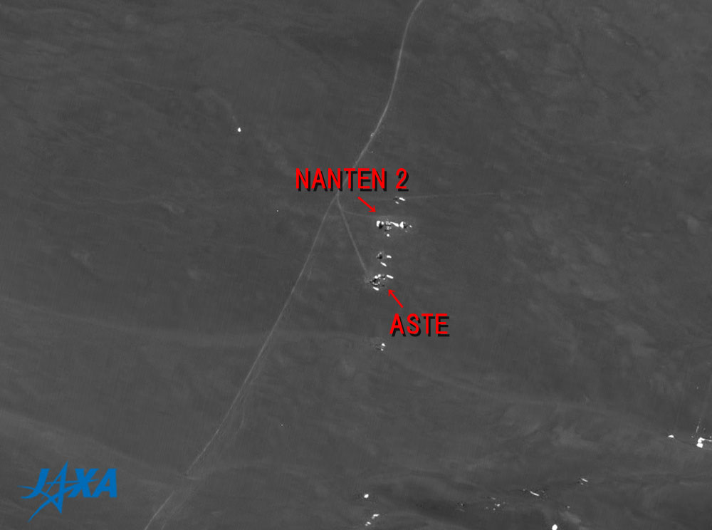
| Fig. 4 Expanded image of Pampa la Bola |
Figure 4 is an expanded image of Pampa la Bola in Fig. 2. The radio telescope ASTE (Atacama Submillimeter Telescope Experiment), operated by Japan's National Astronomical Observatory and a collaboration of universities including Chile University, and radio telescope NANTEN2 (NANTEN Submillimeter Observatory ), operated by an international collaboration of universities led by Nagoya University, can be seen with their related facilities.
 |
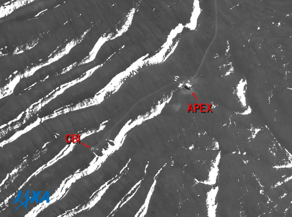
| Fig. 5 Expanded image of Llano de Chajnantor |
Figure 5 is an expanded image of Llano de Chajnantor in Fig. 2. Radio telescope APEX (Atacama Pathfinder Experiment), operated through collaboration among German's Max Planck Institut für Radioastronomie (MPIfR), Sweden's Onsala Space Observatory (OSO), and the European Southern Observatory (ESO), and radio telescope CBI (Cosmic Background Imager), operated through international cooperation led by the California Institute of Technology, can be seen with their related facilities.
In the international ALMA (Atacama Large Millimeter and Submillimeter Array) project that started in 2002, Japan, USA, Canada and Europe are constructing a radio interferometer consisting of 80 radio telescopes in Llano de Chajnantor and will complete it in 2011. This radio interferometer will have the world's highest performance in the submillimeter wave bands. The researchers intend to investigate mysteries such as the birth of the galaxies, the birth of the solar system, and the evolution of material from the Big Bang to life forms.
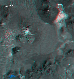 |
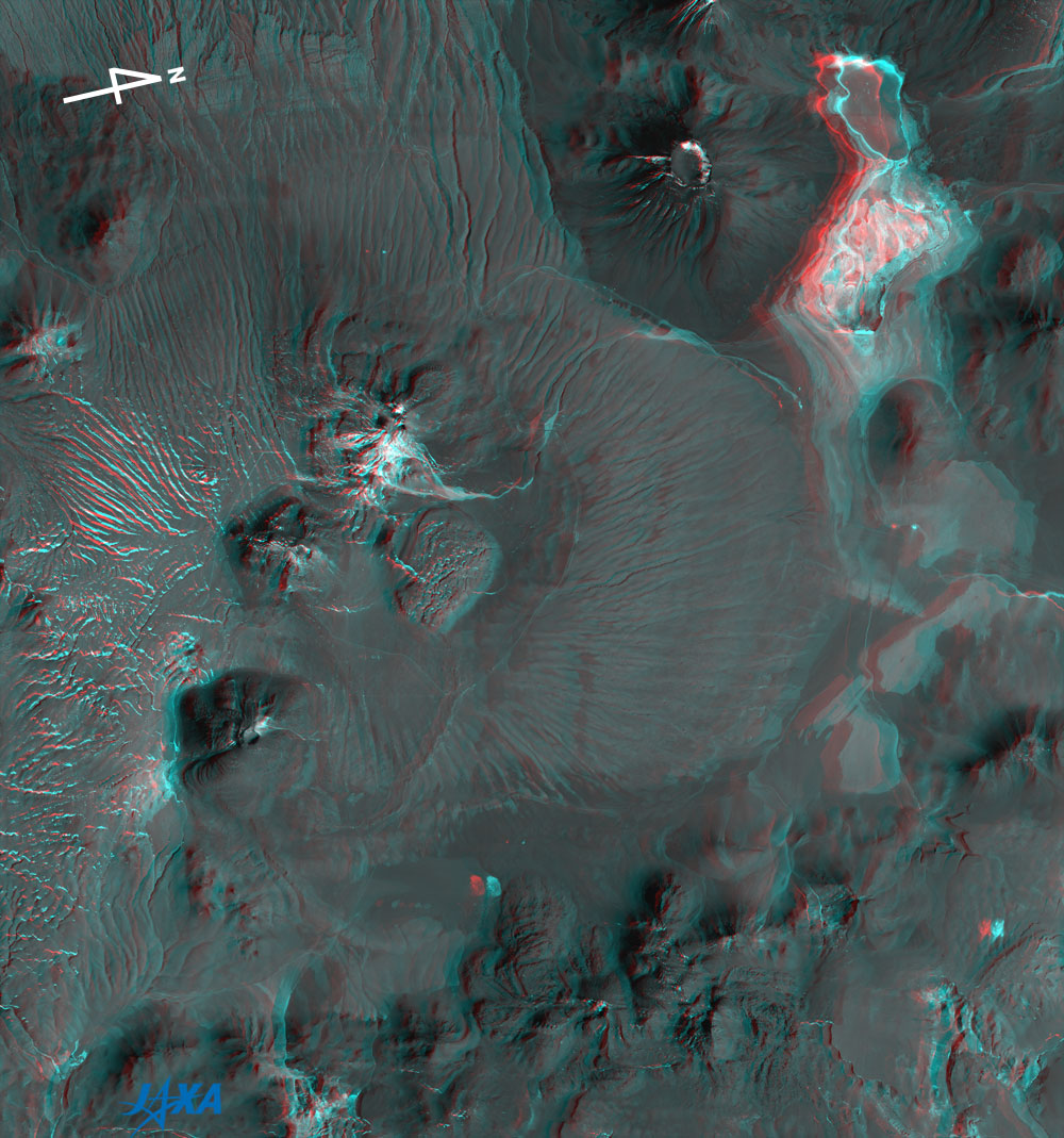
Fig. 6 Three-dimensional View of Atacama Plateau
(Staring at the image for a long time may cause eye strain. A colored print is available in pdf format. Pdf files for left and right eye lenses are also available.)
|
Figure 6 is a three-dimensional view composed of the nadir-looking image and the backward-looking image acquired by PRISM in July 2006. Please note that north is toward the right side. If you view the figure with red and blue glasses, you can see some cone-shaped volcanoes, lava upheavals, flat lakes, and subtle unevenness of the landform.
Explanation of the Images:
(Fig.1)
| Satellite: |
Advanced Land-Observing Satellite (ALOS) (Daichi) |
| Sensor: |
Advanced Visible Near-Infrared Radiometer type-2 (AVNIR-2) |
| Date: |
1417 (UTC) on May 28, 2006 |
| Ground resolution |
10 m |
| Map Projection: |
Universal Transversal Mercator (UTM) |
| AVNIR-2 has four observation bands. The image was produced by assigning red to Band 3 (610 to 690nm), green to Band 2 (520 to 600nm), and blue to Band 1 (420 to 500nm). The resulting image has natural coloring as if seen by the naked eye. In this image, snow and dried salt soil are white, exposed rocks and soil are brownish, and lakes are light blue. |
(Figs. 2 to 6)
| Satellite: |
Advanced Land-Observing Satellite (ALOS) (Daichi) |
| Sensor: |
Panchromatic Remote-sensing Instrument for Stereo Mapping (PRISM) |
| Date: |
1445-1446 (UTC) on July 4, 2006 |
| Ground resolution |
2.5 m |
| Map Projection: |
Universal Transversal Mercator (UTM) |
PRISM is an optical sensor for observing ground surfaces with visible and near-infrared signals in the 520 to 770 nm (one-billionth of a meter) band. PRISM has three independent optical systems (telescopes) to acquire terrain data including altitude data so that images for nadir, forward, and backward views can be acquired at the same time. The acquired image is monochrome.
Figs. 2 to 5 are backward-looking images, and Fig. 6 was composed of nadir (green and blue) and backward-looking (red) images. In Fig. 6, the left side is the satellite flight direction because the backward-looking image of the satellite is seen with the left eye and the nadir-looking image with the right eye. The left side nearly corresponds to south.
|
|
 |
|