| |
 |
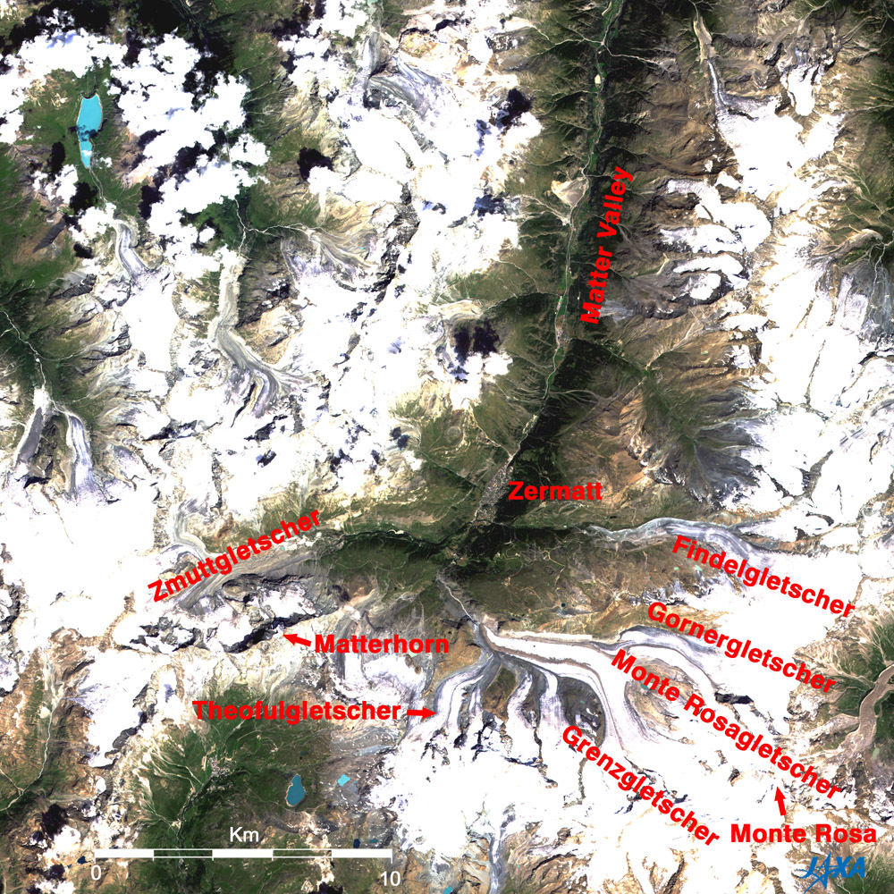
Fig. 1 The Matterhorn and its vicinity
Matterhorn (kmz, 4.59MB, Low Resolution) as seen on Google Earth.
(Full Image) |
Figure 1 depicts the Matterhorn, the symbol of Switzerland, and its vicinity as observed by the Advanced Visible and Near Infrared Radiometer-2 (AVNIR-2) on board the Advanced Land Observing Satellite (ALOS) "Daichi" in July 2006. The valley that extends north from the center of the figure is the Matter valley. Mountains surrounding this valley are covered with snow and ice and shine brightly. In the south of the figure are the Valais (Wallis) Alps that border on Italy. The view includes 4,000m class lofty mountains including the Matterhorn (4,478m above sea level) and Monte Rosa (4,634m, the highest peak in Switzerland and ranking second to Mont Blanc in the Alps) that are clustered here. Many huge glaciers are also visible.
Zermatt, one of the most popular mountain resort towns in Switzerland, is located on the northeast foot of the Matterhorn. In order to protect the natural environment, there are detailed regulations here such as prohibition of combustion engine cars. Public transportation in the village is composed of carriages, electric cars, electric buses, etc. The Alpine Museum has a collection of Zermatt history and records of reaching the summits of the Valais Alps.
Many observation points that overlook the Valais Alps can be reached by mountain railways (one of them goes to the highest place in Europe for a ground surface railway) or by gondolas (one of them reaches the highest spot in Europe). The Glacier Express connects Zermatt and Saint Moritz in eastern Switzerland, covering a distance of 270km in 8 hours.
 |
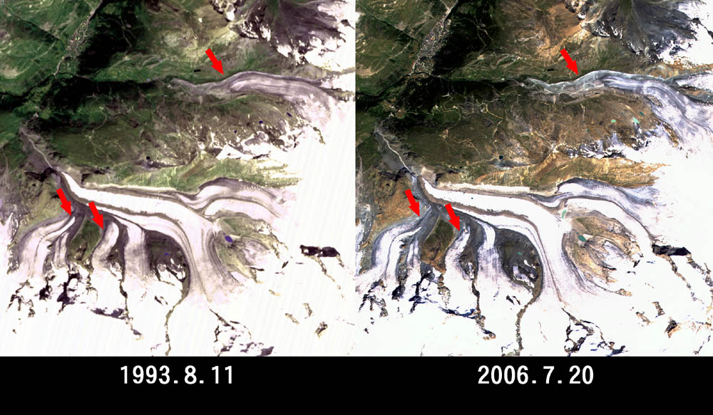
| Fig. 2 Changes of Glaciers |
The glaciers, which carve the geographical features of the Alps, flow dozens of centimeters per year, but the leading edges have recently been retreating at a rate of 20m per year due to global warming. Figure 2 compares the glaciers around the Matterhorn as observed by the Visible and Near Infrared Radiometer (VNIR) on board the Japanese Earth Resources Satellite-1 (JERS-1) "Fuyo-1" in August 1993 and AVNIR-2 on board ALOS. The glacier leading edges (indicated by arrows) shrunk and retreated about 200m to 700m in 13 years, or 15 to 54m per year in average.
Explanation of the Images:
(Fig.1, right of Fig. 2, and the full image)
| Satellite: |
Advanced Land-Observing Satellite (ALOS) (Daichi) |
| Sensor: |
Advanced Visible Near-Infrared Radiometer type-2 (AVNIR-2) |
| Date: |
1030 (UTC) on July 20, 2006 |
| Ground resolution |
10 m |
| Map Projection: |
Universal Transversal Mercator (UTM) |
|
AVNIR-2 has four observation bands. The composite images were produced by assigning red to Band 3 (610 to 690nm), green to Band 2 (520 to 600nm), and blue to Band 1 (420 to 500nm). The resulting image has natural coloring as if seen by the naked eye. In these images, snow and ice are white or light grey, urban area are light grey, forests are dark green, grasslands are green-yellow, and glacier lakes are light blue. Areas with no data are black. |
(Left of Fig.2)
| Satellite: |
Japanese Earth Resources Satellite-1 (JERS-1) (Fuyo-1) |
| Sensor: |
Visible and Near Infrared Radiometer (VNIR) |
| Date: |
1038(UTC) on August 11, 1993 |
| Ground resolution |
18.3 m x 24.2 m |
| Map Projection: |
Universal Transversal Mercator (UTM) |
|
The composite images are usually produced by assigning red to the Band 2 (630 to 690 nm), green to the near-infrared Band 3 (760 to 860 nm), and blue to the visible Band 1 (520 to 600 nm). In the above figure, green is assigned to the sum of 80% of Band 2 and 20% of Band 3. The resulting figures have natural coloring as if seen by the naked eye. In these images, snow and ice are white or light purple, urban area are light grey, forests are dark green, and grasslands are green-yellow. |
|
 |
|