| |
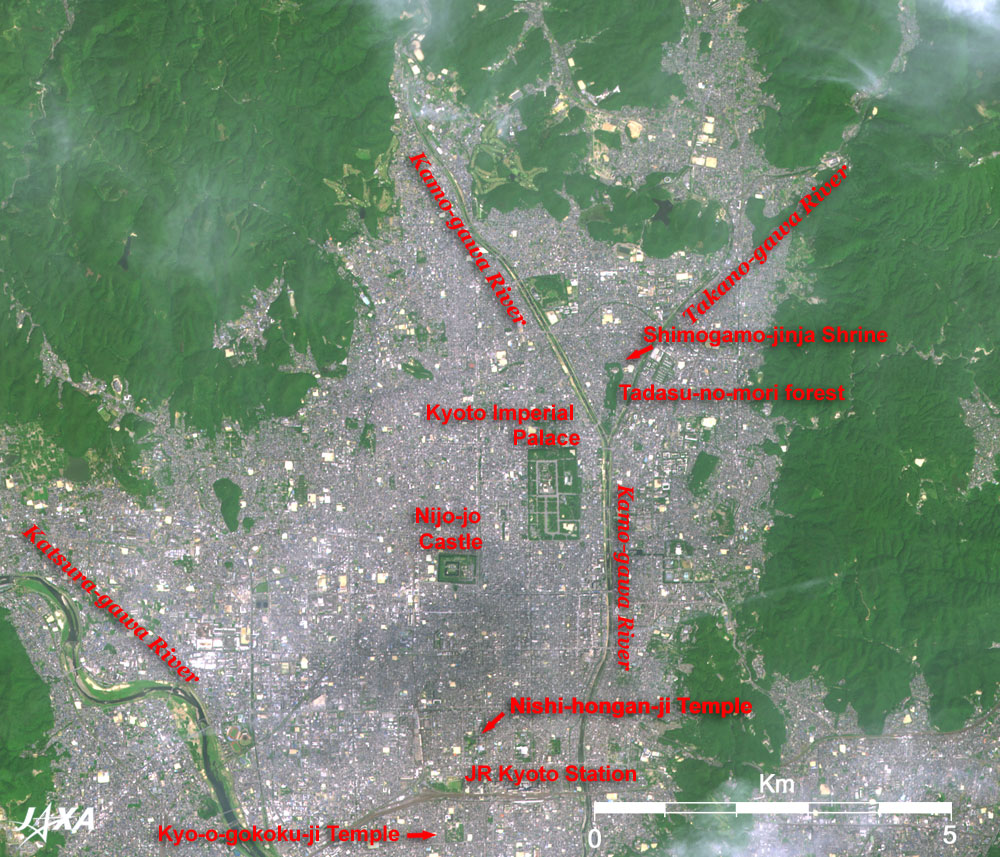
Figure 1 depicts Kyoto and its vicinity as observed by the Advanced Visible and Near Infrared Radiometer-2 (AVNIR-2) on board the Advanced Land Observing Satellite (ALOS) "Daichi" in August 2006. The rectangular green section in the center of the figure is the Kyoto Gyoen Imperial Garden. It is a large, 63-ha park, now open to the public as an oasis in Kyoto City. The Kyoto Imperial Palace, Kenrei-mon-mae-o-dori Avenue, and the Kyoto Guesthouse are clearly visible. The Kamo-gawa and Takano-gawa Rivers, which originate in Kita-yama (North Mountain), merge into another Kamo-gawa River (the kanji character representing the name of the second river differs from that of the first) and flow south beside the Imperial Garden, forming a "Y" path. The dark area in the lower middle section of the figure is the shadow of a cloud.
Kyoto is the location of many valuable cultural assets. Seventeen sites, including temples, shrines, and castles, were added to the list of the World Cultural Heritage of the United Nations Educational, Scientific and Cultural Organization (UNESCO) as "Historic Monuments of Ancient Kyoto (Kyoto, Uji and Otsu Cities)" in 1994. This year was the 1200th anniversary of the establishment of the ancient capitol of Heiann-kyo. Some sites are easily recognized in the image. The rectangular small green tract of land at the lower left of the Imperial Garden is Nijo-jo Castle. The double motes around the castle are clearly visible. Kamomioya-jinja (commonly called Simogamo-jinja) Shrine is located in the vertical long, green forest between the Kamo and Takano Rivers to the upper right of the Imperial Garden. The shrine precincts are in the beautiful Tadasu-no-mori forest, where virgin forest remains. The green space south of Nijo-jo Castle, along Horikawa Avenue near the JR Kyoto Station, is Hongan-ji Temple (commonly called Nishi-Hongan-ji Temple). The roof covering Goeido, currently under repair, shines brightly, reflecting the strong, mid-summer sunlight. The green square across the railway, in the lower left of the figure is Kyo-o-gokoku-ji Temple (commonly called To-ji Temple). It is famous for its Five-Storied Pagoda, but the 10-m resolution of the AVNIR-2 image may be insufficient for recognition.
Kyoto is a scenic area bordered on three sides by mountains. Although it is an inland city, Kyoto provides an important water-transport route for commodities. The Kamo-gawa River joins the Katsura-gawa and Uji-gawa Rivers, forming the Yodo-gawa River, and finally flows into Osaka Bay. The Katsura-gawa River originates near Arashi-yama Mountain. The Uji-gawa River flows from Lake Biwa. Kyoto is thus connected with the Seto Inland Sea by rivers, and with the Sea of Japan and Eastern Japan through Lake Biwa. It is geopolitically advantageous to construct a capital city on this ground, as we can see from the satellite image today. Did ancient people look down upon this ground from the summit of the mountain? If so, their rich imaginative power is a real surprise.
In Emperor Kammu's reign, the capitol was moved to Heian-kyo in Kyoto in 794. The Kamo-gawa River was diverted to its present course, and a rectangular city area, composed of the Imperial Palace and a grid of streets, was constructed on the west side of the river. The remarkable plan of square green tracts and grid structure for the city was inspired by the design of the city of Changan (present Xian), the capital of Sui and Tang of China. The present Kyoto Imperial Palace was actually moved from the site of the ancient Palace. However, To-ji Temple, which was built to the east of the Rajo-mon Gate at the southernmost end of Suzaku-oji Avenue, remains in the same place as in the time when Heian-kyo was built. Raku-chu-raku-gai-zu (perspective drawings of the daily ins and outs of the city) were highly appreciated gifts in Kyoto, ever since the Age of Civil Wars. The full image acquired by a satellite orbiting 700km above the Earth, with some scattered fluffy clouds, creates an aura of Raku-chu-raku-gai-zu of the present Heisei Era.
Explanation of the Image:
| Satellite: |
Advanced Land-Observing Satellite (ALOS) (Daichi) |
| Sensor: |
Advanced Visible Near-Infrared Radiometer type-2 (AVNIR-2) |
| Date: |
1048 (JST) on August 10, 2006 |
| Ground resolution |
10 m |
| Map Projection: |
Universal Transversal Mercator (UTM) |
|
AVNIR-2 has four observation bands. The composite image is usually produced by assigning red to Band 3 (610 to 690nm), green to Band 2 (520 to 600nm), and blue to Band 1 (420 to 500nm). The resulting image has natural coloring as if seen by the naked eye. Thus the ground objects are distinguished by the following colors. |
| Deep green: |
Forests |
| Green or khaki: |
Grass fields, farms |
| Bluish grey: |
City area or roads |
| Blue, dark greenish blue: |
Water surfaces (sea, lakes, rivers) |
| White: |
Clouds, roofs |
| Black: |
The area with no data |
In the above figure, green is assigned to the sum of 80% of Band 2 and 20% of Band 4, resulting in green being vivid and slightly enhanced. |
 |
|