Seen from Space 2006
Fukuoka, a city boasting international exchanges and a long history
| |
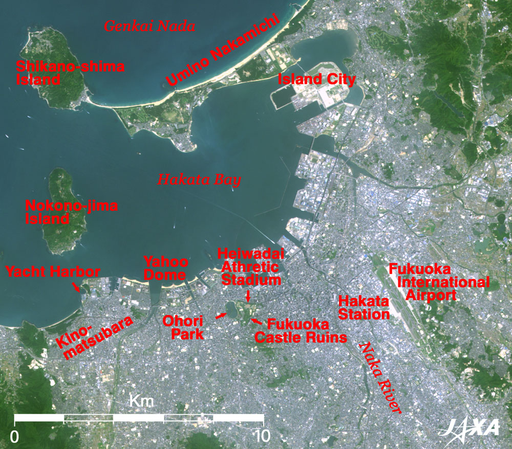
Figure 1 depicts Fukuoka City and its vicinity as observed by the Advanced Visible and Near Infrared Radiometer-2 (AVNIR-2) on board the Advanced Land Observing Satellite (ALOS) "Daichi" in May 2006. The Port of Hakata, the gateway to the sea, is in the center of the image. A high-speed ferry with a white wake approaching the central wharf is an impressive scene. The sandbar separating Hakata Bay and Genkai Nada (the rough sea) is usually called "Umino-Nakamichi;" and there is an island at the tip of the sandbar called Shikano-shima Island. This island is famous for the discovery of a national treasure there, the Gold Seal of "Kan no Wa no Na no Kokuo" (the seal given to the king of ancient Na in the state of Wa (Japan) from the emperor of the late Han Dynasty in ancient China). Nokono-jima Island is located at the mouth of the bay, and this perfect alignment tells us that Hakata is a good natural harbor. The man-made island called "Island City" shines brightly at the deepest part of the bay. A 21st century new town currently under construction seeks to harmonize port development and the natural environment.
Fukuoka International Airport is a gateway to the sky. The airport terminal shines brightly, and the geometric lines of the runway of this airport, the largest in Western Japan, are clearly visible. It is located adjacent to the downtown area and is known as the most convenient and easiest airport to access in Japan. It takes only about 5 minutes by subway from Hakata Station, the doorway to the airport. The holm in the downstream area of the Naka River, which flows through the center of the city, is famous as the busiest amusement district in Kyushu. The green belt in the center of the figure is a park district including Ohori Park, with O-ike (a pond 2km in circumference), the Heiwadai Athletics Stadium, and the Fukuoka Castle Ruins Park; these are an oasis for the citizens of Fukuoka City.
There are many entertainment facilities on the seafront in the upper left of Ohori Park. You can see a unique man-made beach with sands glistening yellowish white due to their high reflectance and with some jetties preventing sand outflow. Also, there is Fukuoka Yahoo! Japan Dome (Yahoo Dome) whose hemispheric roof partially shines white due to reflected sunlight. The Fukuoka SoftBank Hawks, one of the teams of the professional baseball Pacific League, play their home games at the Dome. A yacht harbor with floating piers can be seen as well. The beautiful bow-shaped beach on the left edge of the figure is the Kino-Matsubara (pine tree forest) swimming beach and is loved by the citizens for its scenery. A bulwark against Mongolian invasion in the Kamakura Era remains here. The pine trees in the forest are more than 100 years old.
"Fukuoka" and "Hakata" are alternate names for Fukuoka City. Hakata first appeared in the Nara Era in the 8th century, and it is the name which represents a merchant town having a history of more than 1200 years. "Fukuoka" comes from the fact that Nagamasa Kuroda became the feudal lord of this territory in the Edo Era in the early 17th century and built Fukuoka Castle. It is located in the northernmost end of Kyushu and has prospered as a base of international exchange from ancient times taking advantage of geographical conditions facing toward China and the Korean Peninsula across Genkai Nada. Fukuoka is an international exchange city with a long history from the time of Na-no country in the 1st century as incused on the Gold Seal of the above-mentioned national treasure.
Explanation of the Image:
| Satellite: |
Advanced Land-Observing Satellite (ALOS) (Daichi) |
| Sensor: |
Advanced Visible Near-Infrared Radiometer type-2 (AVNIR-2) |
| Date: |
1138 (JST) on May 4, 2006 |
| Ground resolution |
10 m |
| Map Projection: |
Universal Transversal Mercator (UTM) |
| AVNIR-2 has four observation bands. The composite image is usually produced by assigning red to Band 3 (610 to 690 nm), green to Band 2 (520 to 600 nm), and blue to Band 1 (420 to 500 nm). The resulting image has natural coloring as if seen by the naked eye. Thus the ground objects are distinguished by the following colors. |
| Dark green: |
Forests |
| Green or khaki: |
Grass fields or farms |
| Bluish grey: |
Urban area or streets |
| Blue or Dark blue green: |
Water surfaces (sea, rivers, ponds) |
| White: |
Clouds or roofs |
| Black: |
The area with no data |
| In the above figure, green is assigned to the sum of 90% of Band 2 and 10% of Band 4 with the result that green is vivid and slightly enhanced. |
|
 |
|