Seen from Space 2006
From Pioneering to Tourism: Sapporo, Hokkaido
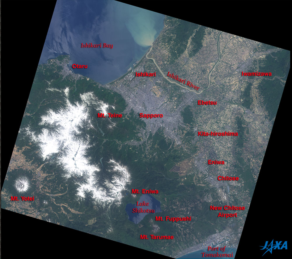
On the upper left of the figure is Ishikari Bay that connects the Sea of Japan and the Ishikari River, which flows from the upper right and pours muddy water into Ishikari Bay. Snow-covered mountains appear in the lower left of the figure, and Mt. Yotei, where white snow and deep green forest surround the summit circular crater, can be seen in the corner. You can also see Lake Shikotsu that is shaped like the Japanese hand drum "tsuzumi." Mt. Eniwa on the north side and Mt. Fuppushi and Mt. Tarumae on the south side form the narrows of Lake Shikotsu. The New Chitose Airport and the Port of Tomakomai are visible on the east side of Lake Shikotsu. The gray area at the center of the figure is Sapporo. Otaru City and Mt. Teine are in the upper left. Development of the Sapporo city area was begun in the flat on the east side of Mt. Teine, which blocks the wind, approximately 140 years ago in order to avoid the seasonal northwest wind. Neighboring Sapporo, you can see its gray bedroom suburbs: Ishikari City, Ebetsu City, Kita-hiroshima City, and Eniwa City clockwise from the north. In the upper right of the figure, you can also see the city area of Iwamizawa City. Vast rice paddy areas extend from both sides of the Ishikari River and in the east side of Kita-hiroshima and Eniwa. They appear ocher indicating that it is before the rice planting and that they are not yet filled with water.
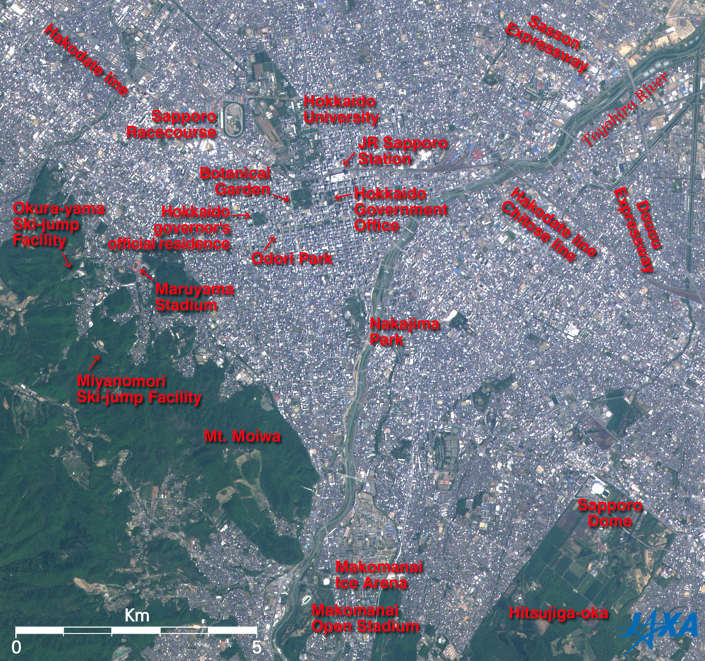
Thick green forests containing the wild woods in Mt. Moiwa can be seen in the lower left. You can see the vivid orange track of the Sapporo City Maruyama Stadium on the extension west of Odori Park. The Okura-yama Ski-jump Facility can be seen on the left of the stadium, and the Miyanomori Ski-jump Facility in the lower left. Ski jumpers used both facilities in the winter Olympic Games in 1972. At the Miyanomori Ski-jump Facility, three skiers from Japan, including Yukio Kasaya, monopolized gold, silver and bronze medals in the 70m-class jump (present normal hill jump). The Makomanai Ice Arena and Makomanai Open Stadium, which were also used for the Sapporo Olympics, can be seen near the bottom of the figure. The Sapporo Dome, which looks like a white cocoon, can be seen in the lower right. It opened in 2001 and has been used as one of the home bases of Consadole Sapporo, a team belonging to Japan's football "J-League," and the home base (since 2004) of the Hokkaido Nippon Ham Fighters, a team in Japan's professional baseball Pacific League. The green rectangular tract where the Sapporo Dome is located is Hitsujiga-oka. This area is home to several research institutes, including the Sapporo Branch, Yokohama Plant Protection Station, the Ministry of Agriculture, Forestry and Fisheries; the Hokkaido Research Center, the Forestry and Forest Products Research Institute; and the Hokkaido Ishikari Livestock Hygiene Service Center. Development of the city area of Sapporo was begun after Japan's Meiji government established the Kaitakushi (Colonization Commission) in 1869 (Meiji second year) as one of the ministries and agencies for the northern pioneering. The population in Hokkaido was 5,630,000 as of the end of March 2005, and that in Sapporo was 1,860,000. Taking advantage of the Sapporo Olympics in 1972, the development of the traffic infrastructure in Hokkaido moved ahead and the tourism industry expanded. The number of visitors from outside of Hokkaido during the recent several years was constant at approximately 6,300,000. Among these, visitors from foreign countries, particularly Taiwan, China and Korea, increased substantially from 240,000 in FY 2001 to 510,000 in FY 2005.
|
|||||||||||||||||||||||||||||||||||||||