| |
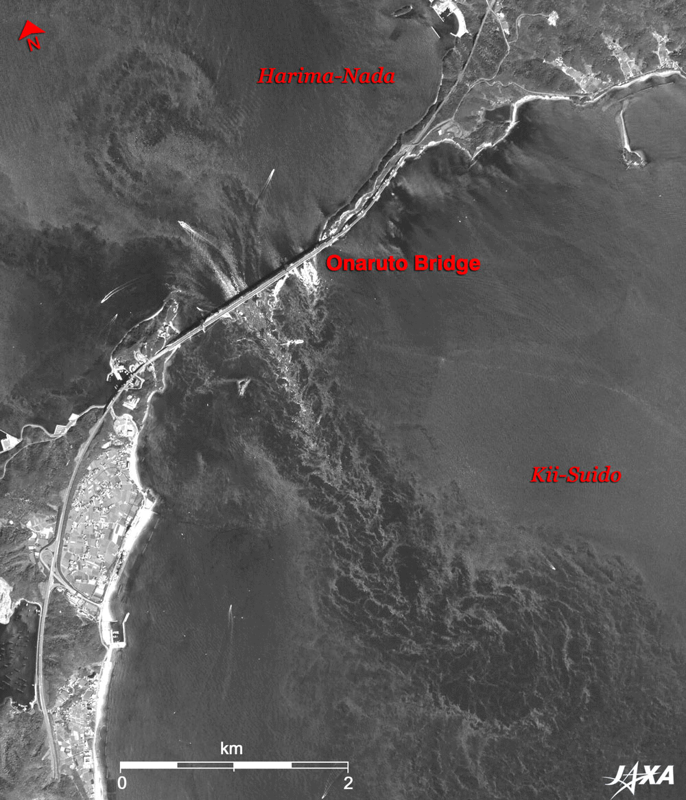
The figure below depicts large Naruto whirlpools as observed by the Panchromatic Remote-sensing Instrument for Stereo Mapping (PRISM) on board the Advanced Land Observing Satellite (ALOS) Daichi in April 2006. Awaji-shima Island (Minami-Awaji City, Hyogo Prefecture) is in the upper right and Shikoku Island (Naruto City, Tokushima Prefecture) is in the lower left. Connecting the two islands is the Onaruto Bridge. When the image was taken, the tide at Naruto Strait was receding, and the tidal current was flowing down from Harima-Nada (rough sea) on the upper left to Kii-Suido (channel) on the lower right. From the Onaruto Bridge, the world's largest Naruto whirlpools form along the current flushing out southeastward.
The figure displays two images: the nadir-looking image observed from the satellite flying from north to south above Naruto and the forward-looking image that was taken 45 seconds before. Therefore, it shows the movement of ships and rushing current accompanied by ocean eddies. The tidal current flowing south from Harima-Nada to Kii-Suido suddenly accelerates near the strait, passes through the middle of the strait, and rushes into Kii-Suido, forming a whirlpool with current eddies on both sides of the stream. The Naruto whirlpool is known as the largest one in the world. Its diameter exceeds 15m, and its current speed, 10 knots (about 20 km per hour).
The center of the funnel-shaped 10m-class-diameter whirlpool, often seen from tourist boats, sinks 1 or 2m below the surroundings. It gives us an intense impression that it is engulfing everything and pulling it down into the ocean depths. However, such a form lasts only for dozens of seconds, and eventually disappears. Although the level difference between the vortical center and the surrounding sea surface disappears, the whirlpool does not. A large vortex about 1.2 km in diameter in the lower right of the figure evolved from the merging of many 10m-class whirlpools. A still larger vortex with a diameter of 1.5 km is faintly visible at Harima-Nada and is a remnant of a vortex, which grew during the flux about 6 hours before.
High tide and low tide occur twice a day, as does the flux from low tide to high tide and the reflux from high tide to low tide. Therefore, intense whirlpools form in Naruto Strait four times a day, driven by the flux and reflux. When the image was taken at 10:50 A.M. on April 28, 2006, the tide of Naruto Strait was refluxing as the low tide occurred at 12:11 P.M. during spring tide.
In addition, near the German Village Park in Oasa-Cho, Naruto City, at the left of a full image, is the Bando Prisoner-Of-War (POW) Camp where about 1,000 German soldiers, who became POWs in Chingtao, China, during the World War I, lived for about three years (from 1917 to 1920). This camp is famous as the place where Beethoven's Ninth Symphony "The Chorus" was first performed in Japan. A jet contrail and its shadow are also visible in the lower right.
Explanation of the Image:
| Satellite: |
Advanced Land Observing Satellite (ALOS) Daichi |
| Sensor: |
Panchromatic Remote-sensing Instrument for Stereo Mapping (PRISM) |
| Date: |
1050 (JST) on April 28, 2006 |
| Ground resolution: |
2.5 m |
|
PRISM is an optical sensor for observing ground surfaces with visible and near-infrared signals in the 520 to 770 nano-meter (one-billionth of a meter) band. The acquired image is monochrome. It has three independent optical systems (telescopes) to acquire terrain data including altitude data so that images for nadir, forward, and backward views can be acquired at the same time. |
|
 |
|