| |
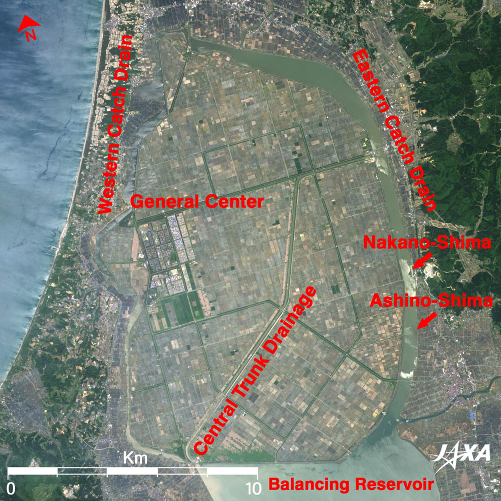
This figure depicts Hachiro-gata (lagoon) as observed by the Advanced Visible and Near Infrared Radiometer type-2 (AVNIR-2) on board the Advanced Land Observing Satellite (ALOS) "Daichi" in May 2006. This lake is located at the root of Oga Peninsula in Akita Prefecture, looking at Shirakami-Sanchi (mountain range), a World Heritage site, far to the north. It was the largest brackish lake next to Lake Biwa in Japan, but it now includes Ohgata-mura (village) built on a large area of reclaimed land. The lake bed reclaiming project began in 1957 using technologies imported from the Netherlands and was completed in 1977, resulting in 17,000ha of fertile land. The former Hachiro-gata is fringed with relict lakes (balancing reservoir, eastern catch drain, and western catch drain) surrounding Ohgata-mura. They are now fresh-water angling lakes famous for carp, crucian carp, surf smelt, etc. Nakano-shima (island) and Ashino-shima in the eastern catch drain are the best fishing spots.
The habitation area in Ohgata-mura is called the "General Center," and the houses there look like small dots. This area is completely separated from agricultural area but connected by trunk roads and branch roads in a grid pattern. The road along the most conspicuous central trunk drain is the "Ohgata-mura Solar Sports Line." This two-lane, 7m wide and 30km long circuit road was authorized as the world's first formal race course for solar cars in 1994. It is visible as a light gray line in the figure.
The agriculture in Ohgata-mura is based on 100 by 100 m blocks of land, which is approximately three times larger than the conventional average in Japan, aiming at farming by the large machinery. The difference of farm sizes is clearly seen when compared with the surrounding towns and villages. This image contains very few green areas because the May observation date falls in the season for filling paddies with water and just before rice planting. Each end of the main drains, running across the whole agricultural area, is equipped with a drainage pumping station to discharge excess water to the relict lakes because it is always necessary to adjust the water level of the reclaimed lands as the whole village is below sea level.
Explanation of the Image:
| Satellite: |
Advanced Land-Observing Satellite (ALOS) (Daichi) |
| Sensor: |
Advanced Visible Near-Infrared Radiometer type-2 (AVNIR-2) |
| Date: |
1047 (JST) on May 27, 2006 |
| Ground resolution |
10 m |
| Map Projection: |
Universal Transversal Mercator (UTM) |
|
AVNIR-2 has four observation bands. The composite image is usually produced by assigning blue to Band 1 (420 to 500nm), green to Band 2 (520 to 600nm), and red to Band 3 (610 to 690nm). The resulting image has natural coloring as if seen by the naked eye. Thus the ground objects are distinguished by the following colors. |
| Dark green: |
Forests |
Green or khaki,
purple-grey: |
Grass fields, farms, paddy |
| Gray: |
City areas or roads |
| Red, blue, white: |
Roofs of buildings |
Blue, bluish gray,
greenish gray: |
Water surfaces (sea, lakes, rivers) |
| White: |
Snow, clouds, or jet contrails |
|
 |
|