Seen from Space 2006
Nagoya Castle and the Evolution of Transport Infrastructure
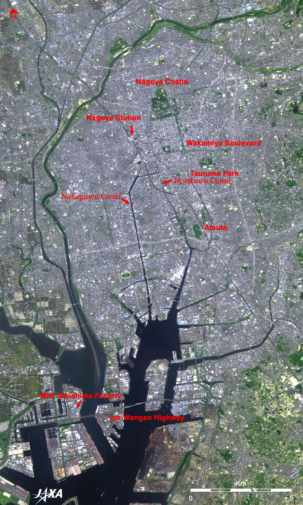
The brown lines stretching up and down Nagoya Station are railroads. The JR (Japan Railways) Tokaido Shinkansen Line, Tokaido Line, and Meitetsu Nagoya Line run parallel diagonally from the upper left to the lower right. The JR Chuo Line runs side-by-side with the Tokaido Line for a while, and branches off northward running on the west side of Tsuruma Park. The other line that runs south from Nagoya Station and soon turns southwest is the Kintetsu Nagoya Line. Nagoya, the central city of the Chukyo Industrial Area has prosperous aircraft industries from pre-war days. One quarter of the city area was lost or destroyed during World War II. However, under the post-war city reconstruction project, Japan's largest (100 m wide) roads were constructed. Hisaya Boulevard runs south 2 km from the southeast corner of Nagoya Castle, intersecting with Wakamiya Boulevard that extends 4 km from east to west. Traffic lanes do not occupy the entire 100 m width of the boulevard, for there are parks and trees along the route. An elevated highway now runs over Wakamiya Boulevard. When seen from the sky, it makes the boulevard look like a wide avenue. As you can see, the transport infrastructure evolved from the waterway to the railroads and to the roads, along with the city developments and technological innovations. Going south down Nakagawa Canal to Nagoya Harbor, the vast areas of reclaimed lands can be seen, penetrated by the Ise Wangan Highway. Located just near the Tobishima ramp of the highway is the Tobishima Factory of Nagoya Aerospace Systems Works of Mitsubishi Heavy Industries, Ltd. The H2A launch vehicle, which carried ALOS "Daichi" into orbit, was built here. It was then shipped to Tanegashima Island by sea. Therefore, you could say that the transport infrastructure is now extending from here into space. In the past, transport between Miya (Atsuta)-no-juku (posting station) and Kuwana-no-juku of "The Fifty Three Tokaido Posting Stations" was only by sea. The distance between the two stations was 7-Ri (28 km), and was called "Shichiri-no-watashi" (7-Ri punt). It is known that punts went back and forth around the Tobishima area, but no one ever dreamed that launch vehicles, or punts into space, would be built here 400 years later.
|
|||||||||||||||||||||||||||||