| |
 |
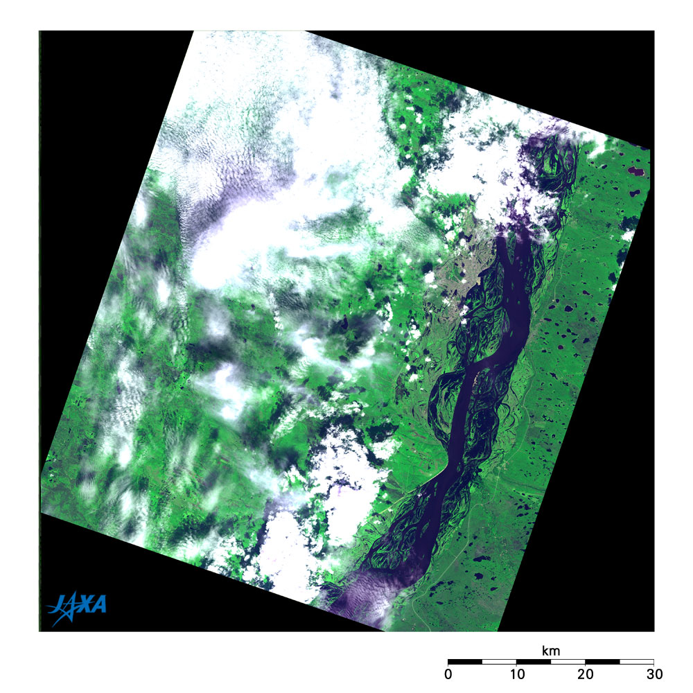
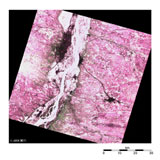
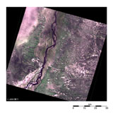
| Fig. 1 Lena River and vicinity of Yakutsk observed by AVNIR-2 |
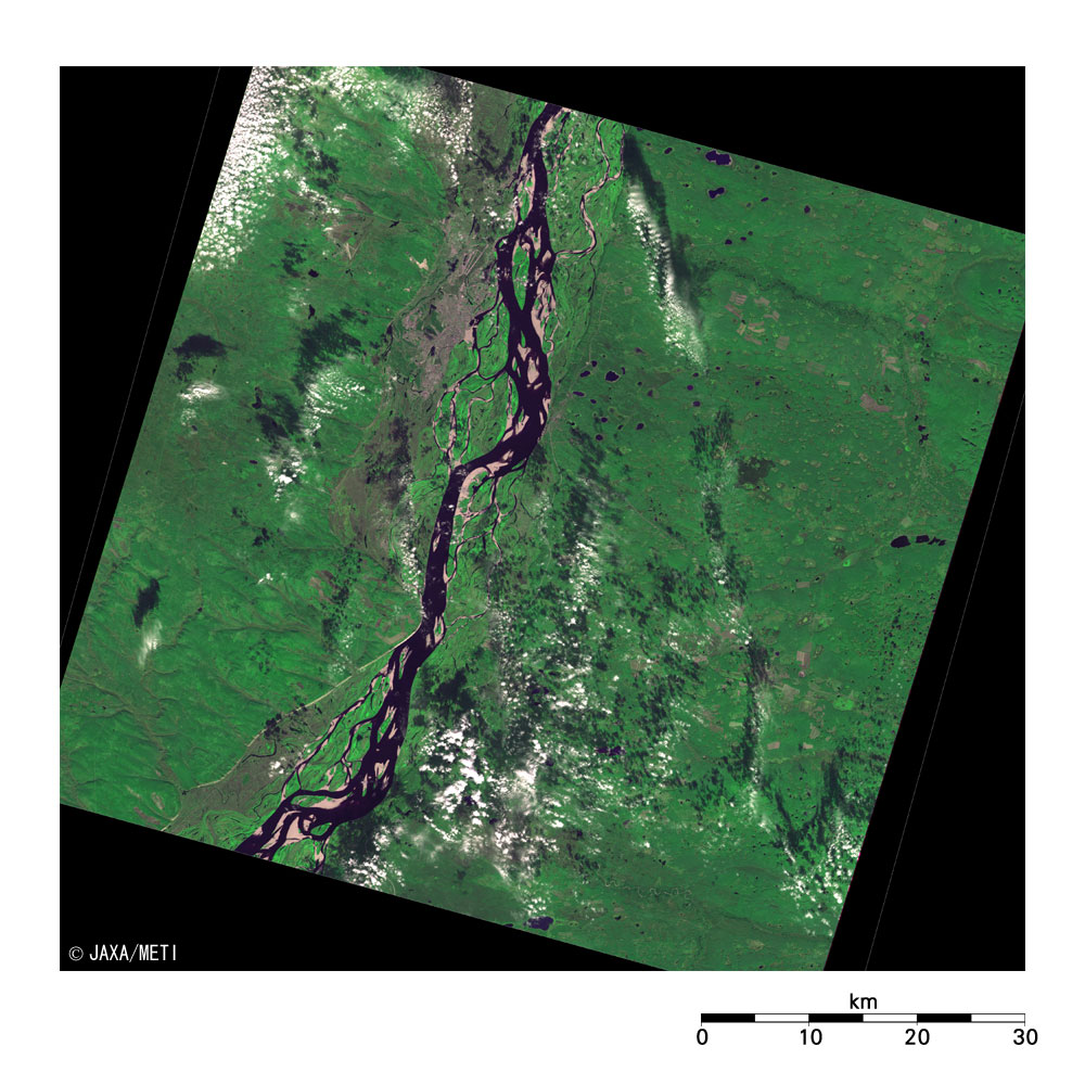
Figure 1 depicts Yakutsk and its vicinity as observed by the Advanced Visible and Near-Infrared Radiometer 2 (AVNIR-2) aboard the Advanced Land Observing Satellite (ALOS) "Daichi" in the beginning of the last month (June 2006). Although there are many clouds, you can see the Lena River flowing from south to north. It is swollen to approximately 10 km wide because it is now in the thawing season. Yakutsk is the capital of the Sakha (Yakutia) Republic, a Siberian region of the Russian Federation, and you can find the city on the left bank of the Lena River at the top of the figure.
 |
 |
 |
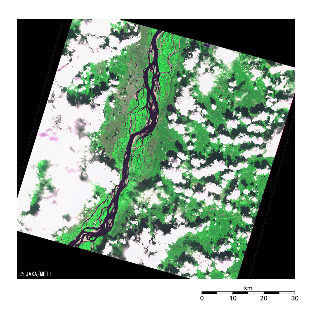
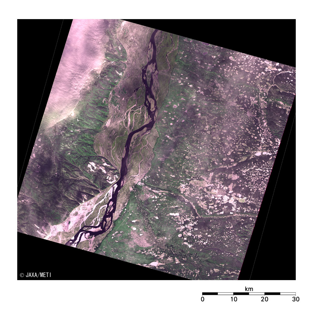
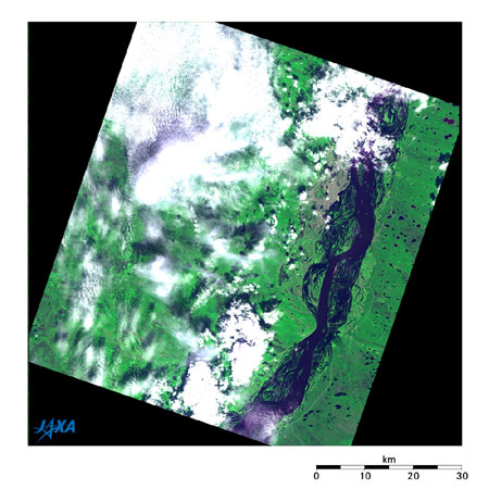
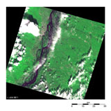
| (a) April 29, 1995 |
(b) June 25, 1994 |
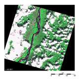
(c) July 26, 1995 |
 |
 |
|
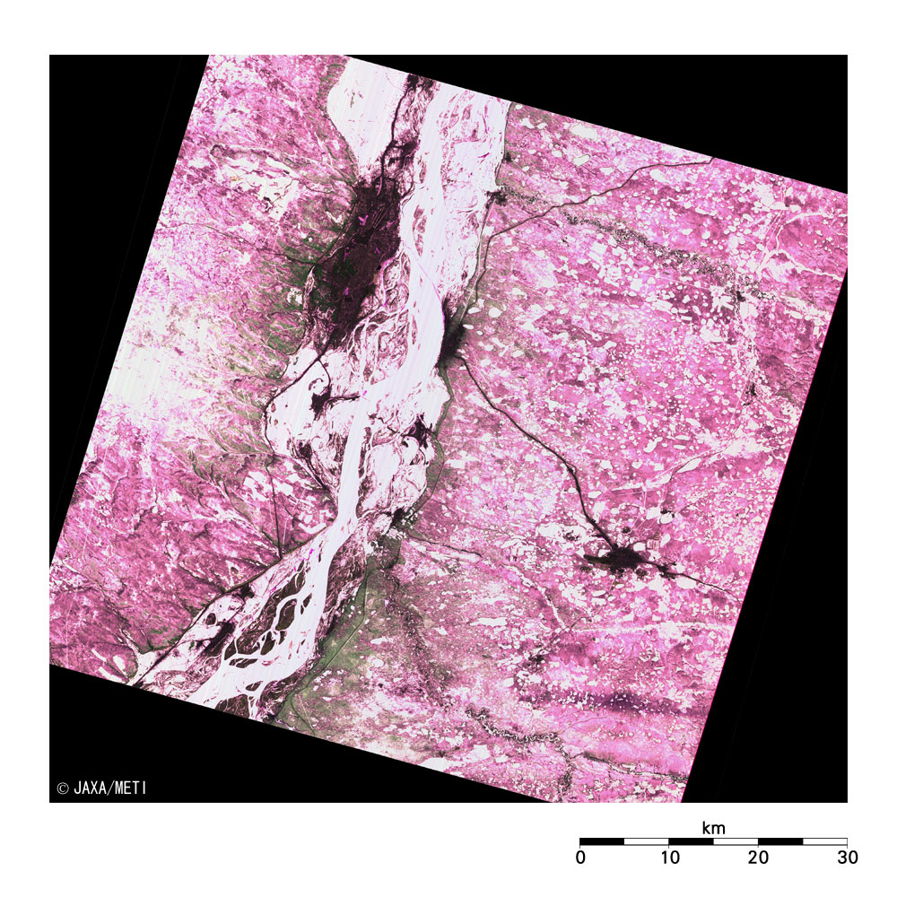
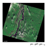
| (d) September 8, 1995 |
(e) October 22, 1995 |
|
| Fig. 2. Seasonal change of Lena River observed by JERS-1/VNIR |
Figures 2a to 2e depict the vicinity of Yakutsk observed by the optical sensor aboard the Japanese Earth Resources Satellite 1 (JERS-1) "Fuyo-1" in 1994 and in 1995. You can understand the seasonal change when arranging the images in the order of the observed date regardless of the observation year. At the end of April, the whole image is still covered with snow and ice, and the Lena River is frozen. By June, the river reaches its widest due to the thaw. It then returns to its usual size in July and in September, and it deceases and becomes covered in snow in October.
Most of the areas in Figs. 2b and 2d look dark green, indicating that it is covered with taiga (the coniferous forests in Siberia), with lakes and marshes here and there. Additionally, there are some clusters of ocher and light-green squares and trapezoids; areas where the forests were clear-felled for timber.
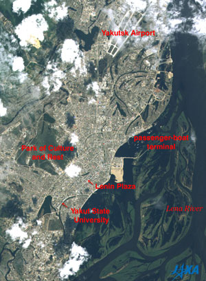 |
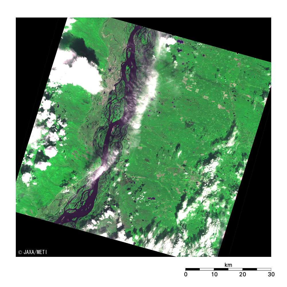
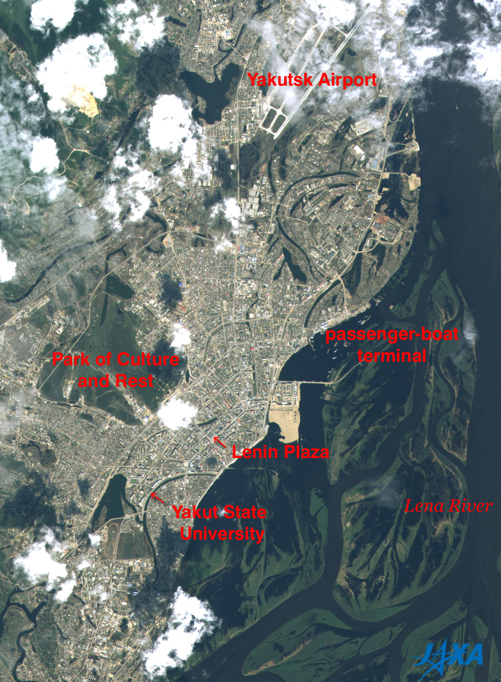
Fig. 3. City area of Yakutsk observed by AVNIR-2
Yakutsk (kmz, 2.55MB, Low Resolution) as seen on Google Earth. |
Figure 3 is an expanded true-color image of the city area of Yakutsk. The lower-right half of Fig. 3 is the Lena River, and its intricately shaped sandbanks can be seen in the wide river. Although there are some clouds, the Yakutsk Airport can be seen at the top, the passenger-boat terminal on the right and the Park of Culture and Rest on the left. Just below the center of the figure is square-shaped Lenin Plaza, and just to the upper left of the Lenin Plaza you can find the Sakha Republic government office building. The Yakut State University in the lower left houses the Mammoth Museum, and the Permafrost Research Institute is in the far lower left.
Explanation of the images:
Figs. 1 and 3
| Satellite: |
Advanced Land-Observing Satellite (ALOS) (Daichi) |
| Sensor: |
Advanced Visible Near-Infrared Radiometer type-2 (AVNIR-2) |
| Date: |
1256 (UT) on May 5, 2006 |
| Ground resolution |
10 m |
| Map Projection: |
Universal Transversal Mercator (UTM) |
AVNIR-2 observes the Earth's surface with its four spectral bands. The color composition of Fig.1 was made by using three out of four AVNIR-2 bands: visible Band 3 (610 to 690 nm) for red, near-infrared Band 4 (760 to 890 nm) for green and visible Band 1 (420 to 500 nm) for blue. As a result, the figure has a natural coloring with slightly emphasized vegetation. Clouds look white; the city area, grayish purple; forests, dark green; grasslands and farmlands, light green; and water surfaces (lakes, ponds, and rivers), black. Areas with no data are also black.
The color composition of Fig. 3 was made by using three out of four AVNIR-2 bands: visible Band 3 (610 to 690 nm) for red, visible Band 2 (520 to 600 nm) for green and visible Band 1 (420 to 500 nm) for blue. As a result, the figure has a natural coloring. Clouds appear white; the city area, bluish gray; the roofs of the buildings, in their original red, blue, and white; forests, dark green; grasslands and farmlands, light green; and water surfaces (lakes, ponds, and rivers), dark blue.
|
Figs. 2a to 2e
| Satellite: |
Japanese Earth Resources Satellite-1 (JERS-1) (Fuyo-1) |
| Sensor: |
Visible and Near Infrared Radiometer (VNIR) |
| Date: |
April 29, 1995 (Fig. 2a); June 25, 1994 (Fig. 2b); July 26, 1995 (Fig.2c); September 8, 1995 (Fig.2d); and October 22, 1995 (Fig. 2e) |
| Ground resolution |
18.3 m x 24.2 m |
| Map Projection: |
Universal Transversal Mercator (UTM) |
|
The figures were produced by assigning red to visible Band 2 (630 to 690 nm), green to near-infrared Band 3 (760 to 860 nm), and blue to visible Band 1 (520 to 600 nm). The resulting figures have a natural coloring with slightly emphasized vegetation.
In these images, the clouds are white, the urban area is purple-gray, the forests are dark green, the grasslands and farmlands are light green, snow and ice are white or purple, and water surfaces (lakes, ponds, and rivers) are black. Areas with no data are also black.
|
|
 |
Related Sites:
 ALOS Research and Application Page ALOS Research and Application Page
Land, Seen from Space
Appendix:
The area of the Sakha Republic is 3.1 million km2, more than eight times the area of Japan, and most of the country is covered with permafrost. It is said that the lowest-ever temperature of minus 71.2 °C was measured in January 1926 at Oymyakon in the eastern Sakha Republic (approximately 850 km east of Yakutsk), and the cold-pole in the Northern hemisphere is situated there. The main industries are mining industries for diamonds, gold, silver and coal, and forestry and woodcraft industries. Additionally, the Sakha Republic also has natural resources of oil and natural gas. The local diamond industry accounts for 99% of all Russian diamonds and more than 25% of the world's diamonds.
The Lena River originates in Baikal Cordillera on the western coast of Lake Baikal and flows to the northeast, changes direction to north near Yakutsk, and then empties into the Laptev Sea that is a part of the Arctic Ocean. It is 4,400 km long and is the 10th longest river in the world. Flooding often occurs midstream and downstream because the thawing of the Lena River basin begins upstream in the southern area. In May 2001, the entire city of Lensk, 800 km west-southwest of Yakutsk, suffered extensive damage due to flooding.
In recent years, the number of mammoths found frozen inside the melting permafrost in Siberia has increased due the affects of global warming. The head of the mammoth exhibited at Expo 2005 in Aichi Prefecture in Japan last year was discovered near Yukagir village, approximately 1,200 km north of Yakutsk, in the fall of 2002. It was first taken to the Mammoth Museum in Yakutsk and then transported to Japan by air.
|
|