Seen from Space 2006
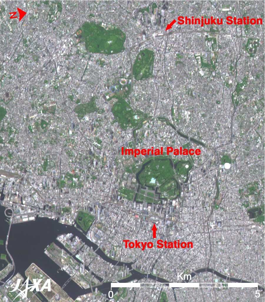
Central Tokyo Dotted with Green Areas and Skyscraper-Clusters
Many skyscrapers can be recognized standing close together west of Shinjuku and the Tokyo stations. The oblique view of Tokyo Tower, the Roppongi Hills Mori Tower, and skyscrapers at Shiodome and Tsukuda-jima Island are also depicted. AVNIR-2 can observe not only the nadir but also the oblique bottom by using its pointing mechanism. This image was taken 47°east from the zenith, which is equivalent to 41° west of the oblique bottom from the satellite, making the east walls of the big buildings observable. This large pointing angle enables emergency observations as well as acquiring a pair of stereoscopic images in the cross-track direction. The Imperial Palace was established on the site of Edo Castle. Hideyoshi Toyotomi nominated Ieyasu Tokugawa as a feudal lord in 1590 after his Odawara expedition. He gave Ieyasu this castle to govern the Kanto area including Tokyo. Only temporary repairs were made before Ieyasu resided there. The Edo Shogunate was established in 1603, and the large castle was completed in 1636 during Iemitsu's (Ieyasu's grandson) reign. Most of the areas look dark green, indicating stands of trees. The Imperial Palace Plaza, lower left, or southeast of the Imperial Palace, appears light green as it is a large open lawn dotted with black pine trees. Compared to the deep forest in the Imperial Palace, this plaza has an open and spacious atmosphere. The lower-right (northeastern) area of the Imperial Palace in the old Edo castle was an area containing the Hon-maru (main enclosure) and the Nino-maru (secondary enclosure) in the old Edo castle. From the base of the castle tower to the right (northernmost end) of the main-enclosure site and left (southward) spreads a vast grassy area also seen as light green. The site of the secondary enclosure is the only Japanese Garden in the Imperial Palace, which was constructed in the Edo Era. To the right (north) area of the Imperial Palace is the Kitano-maru National Garden, which was the site of the old Imperial-Guards regiment and has now been converted to a forest park. Evergreen trees are planted here, in harmony with the Imperial Palace forest. To the right (northernmost end) of the palace is a white circular structure known as the Budokan (the Martial Arts Hall). Other facilities, such as the Science and Technology Museum and the National Museum of Modern Art, are also located in this garden.
|
|||||||||||||||||||||||||||||