ページの先頭です。
本文へジャンプする。
【Important Notices】This page is an archive page of information published in the past. Since the update has been completed, it may contain broken links or outdated information. For the latest information, please use the new site Earth-graphy (earth.jaxa.jp).
ここからサイト内共通メニューです。
サイト内共通メニューを読み飛ばす。
サイト内共通メニューここまで。
ここから本文です。

Seen from Space 2006

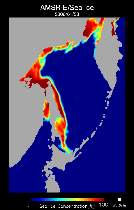
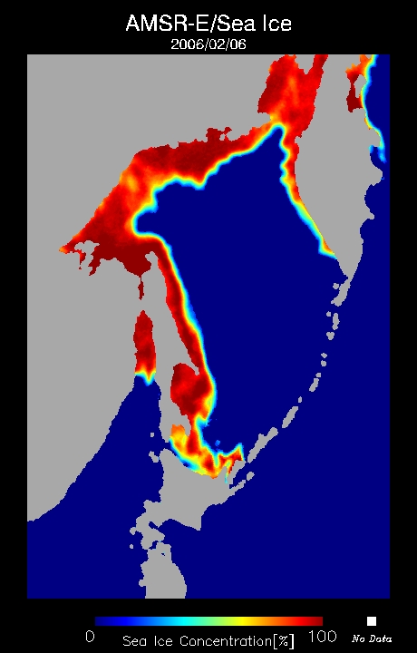
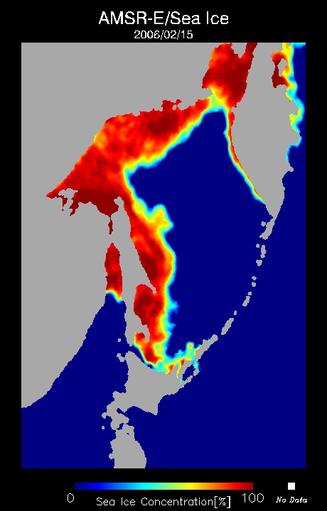
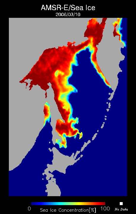
Sea Ice Distribution in the Sea of Okhotsk during 2005 - 2006 Winter

 
Fig. 1 2006/01/23 Fig. 2 2006/02/06 Fig. 3 2006/02/15
Fig. 4 2006/03/10 Fig. 5 2006/03/28 Fig. 6 2006/04/05
Sea Ice Distribution in the Sea of Okhotsk observed by Aqua/AMSR-E
Animation (3.64MB)   (16.9MB)
The animation including Figures 1 to 6 present the distribution of sea ice in the Sea of Okhotsk derived from Advanced Microwave Scanning Radiometer for EOS, AMSR-E, from Dec. 1, 2005, to May 8, 2006. The animation reveals that the sea ice started to freeze in the mouth of the Amur and near Mamiya strait, moved south with its extent increasing, approached the Okhotsk coast of Hokkaido at the end of January, came on shore in the beginning of February, and moved away north with its extent decreasing.
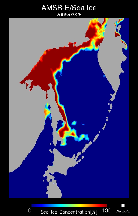
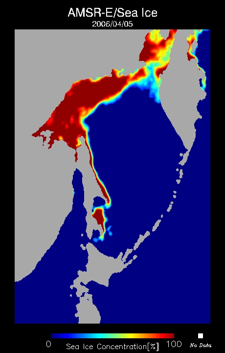
This year, the total amount of sea ice in the Sea of Okhotsk is less than that of an average year. According to the statistics of the Japan Meteorological Agency, especially from December 2005 to January 2006, the amount sea ice there was the lowest since 1971.

Sea ice forms a barrier between seawater and the atmosphere and reflects sunlight four to eight times better than the open sea. It therefore influences the exchange of heat and water vapor between the ocean and the atmosphere. Sea ice extent is being reduced by global warming and is a major factor in global climatological change. Observation of sea ice is thus becoming more and more important.

But the sea ice in this season approached the Hokkaido coast almost as fast as in an average year. For example, Abashiri City on the Sea of Okhotsk recorded the first sighting of drift ice on January 23, 2006 (the first day drift ice is observed from land), and on February 6, 2006, it recorded the "First date of drift ice on shore" (the first date the drift ice covers the coast and ships are unable to navigate). After that, the sea ice weakened, and the drift ice on shore didn't last. On February 25, Abashiri City observed the "First date of shore lead appearance," which is the first date a channel appears and ships are able to navigate again. Furthermore, March 25 was the "Last date of drift ice in sight," which is the last date drift ice observed from land, was observed.

Both the "First date of shore lead appearance" and "Last date of drift ice in sight" were much earlier than in an average year.

As a result, drift ice tourist ship "Aurora," which operates from Abashiri City, saw its passengers decline more than one-third compared to last season. The drift ice tour industry is thus in a depression, and local economies have been greatly damaged.

In contrast, drift ice was first observed from land in Wakkanai City on April 5, some 54 days later than in an average year (on February 11), making it the latest sighting since 1946. It is thought that the ice was near the southeastern tip of Sakhalin Cape Aniva on March 28 and that part of it moved to the west.

Drift ice or icebergs are very dangerous for ships, as demonstrated by the Titanic disaster in 1912. The Japan Coast Guard and the Japan Meteorological Agency therefore publish drift ice information for ships navigating around northern Japan. AMSR-E data is one observation source for this information.

Sea ice influences not only the climate and meteorology but also human industrial activities such as fisheries, marine traffic, and tourism.


Reference Sites:
*1Sea Ice Brief Information (PDF) (JMA's Sapporo District Meteorological Observatory, Japanese only)
*2Sea Ice Related Page (JMA's Abashiri Local Meteorological Obserbatory, Japanese only)
*3Japan Coast Guard Ice information center
*4JMA's Sea Ice Information Page (Japanese only)

Explanation of the images:
Figs. 1 to 6 and animation
Satellite: EOS-Aqua (NASA)
Sensor: Advanced Microwave Scanning Radiometer for EOS (AMSR-E) (JAXA)
Date: January 23, 2006 (Fig. 1), February 6 (Fig. 2), February 15 (Fig. 3), March 10 (Fig. 4), March 28 (Fig. 5), April 5 (Fig. 6), December 1, 2005 to May 8, 2006 (Animation)
These figures present the sea ice concentration calculated based on the algorithm developed by Dr. Josefino C. Comiso from NASA GSFC, one of the Principal Investigators (PIs) for AMSR/AMSR-E algorithm development, by using 36.5-GHz horizontal and vertical polarization data and 18.7-GHz horizontal and vertical polarization data among six observational frequencies of the AMSR-E. The above images indicate the sea ice concentration estimated from the data acquired by AMSR-E. Sea ice concentration is the ratio of ice cover per unit area. The open water area is 0% and the sea-ice covered area is 100%. Areas with low sea ice concentration are light blue and change to yellow and orange corresponding to higher concentrations, with the highest sea ice concentration displayed as red or deep vermilion. The land is gray, the open water surface (sea surface) is deep blue, and no data is white. The spatial resolution is approximately 15 km.

Related Site:
The Coming of Sea Ice Season 2006
Natural Features in Winter: The Arrival of Sea Ice in Hokkaido
Coming of Pack Ice Season
Cryosphere, Seen from Space

本文ここまで。
image:Satellite Navigator
image:Satellite Applications and Operations Center(SAOC)
Earth Data Collection by JAXA Satellites
image:ページTOP