Seen from Space 2006
Three-Dimensional View of Mt. Haruna
| |
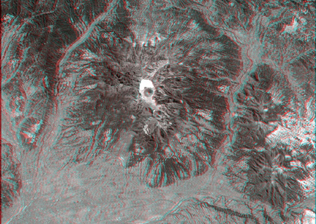 |
| Fig. 1. Three-dimensional view of Mt. Haruna |
| ( Caution should be exercised when viewing this image, as prolonged exposure could result in eye fatigue. After printing with a color printer, use this pdf file. When doing so, replace words such as "the upper" with "the back" and "the bottom" with "the front" in the following explanation. ) |
 |
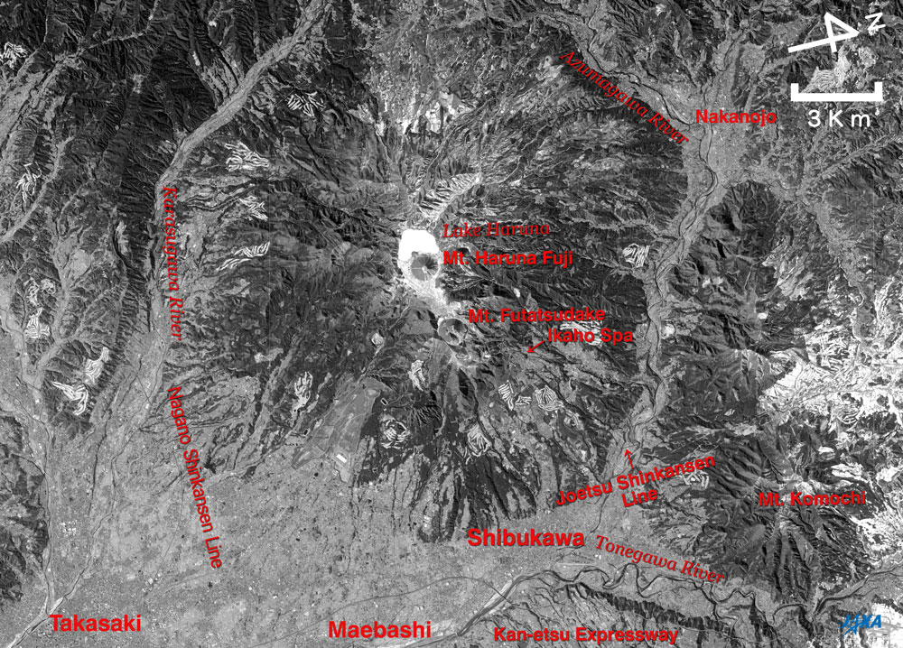
Fig. 2 A guide map of Mt. Haruna
Mt.Haruna (kmz, 1.89 MB, Low Resolution) as seen on Google Earth. |
Mt. Haruna in Fig. 1 looks peaked when viewed with red and blue colored glasses. The small cone in the center of Fig. 1 is Mt. Haruna Fuji, and the white area just above it is Lake Haruna with a frozen surface. The cone on the lower right of Mt. Haruna Fuji is Mt. Futatsudake, and the building cluster in Ikaho spa looks rustic on the slope on the right side of Mt. Futatsudake. The home pages of the Japan Meteorological Agency and other institutes state that the most recent volcanic activity from Mt. Haruna was an eruption in the middle of the sixth century when the lava dome on Mt. Futatsudake was formed. You will also notice that the mountains stand in a ring surrounding Mt. Haruna Fuji and Lake Haruna. This chain of mountains is called an outer rim of a crater. Refer to Fig. 2 for the major place names.
The Karasugawa River flows from the upper to the lower through the left side on the foot of Mt. Haruna, and the Azumagawa River flows through the right side of the foot of the mountain. The Tonegawa River flows from the right to the left on the bottom of Fig. 1. You will notice that the areas where the rivers flow are lower and that the river terraces on the left side of the Karasugawa River and on the lower side of Tonegawa River are higher. The city areas of Takasaki, Maebashi and Shibukawa; the Nagano Shinkansen Line; the Joetsu Shinkansen Line; and the Kan-etsu Expressway lie from the lower left to the lower right of the figure. The white areas that can be seen here and there are golf courses covered with snow.
The on-orbit early checkout of the Advanced Land Observing Satellite (ALOS) "Daichi" was finished as scheduled on May 15, and the calibration and validation phase has been started on May 16.
Explanation of the images:
Figs. 1 and 2
| Satellite: |
Advanced Land Observing Satellite (ALOS) (Daichi) |
| Sensor: |
Panchromatic Remote-Sensing Instrument for Stereo Mapping (PRISM) |
| Date: |
1030 (JST) on February 14, 2006 |
| Ground resolution: |
2.5 m |
PRISM is an optical sensor for observing ground surfaces with visible and near-infrared signals in the 520 to 770 nano-meter (one-billionth of a meter) band. The acquired image is monochrome. It has three independent optical systems (telescopes) to acquire terrain data including altitude data so that images for nadir, forward, and backward views can be acquired at the same time.
Figure 1 was composed using the nadir image (red) and the forward image (green and blue); Fig. 2 was composed by using the nadir image. Parallax, the difference between the sight angle of the image seen with the right and left eyes, is utilized in order to view the three dimensional image. In Fig. 1, the left side is the satellite moving direction because the nadir of the satellite is seen with the left eye and the forward with the right eye. The left side corresponds to the south and the right to the north because "Daichi" circles the polar orbit passing over the Arctic and the Antarctic and flies from the north to the south on the daytime side of the earth. Note that the right side is the north direction in Figs. 1 and 2 even though the upper side is north in many satellite images.
|
|
 |
|