| |
 |
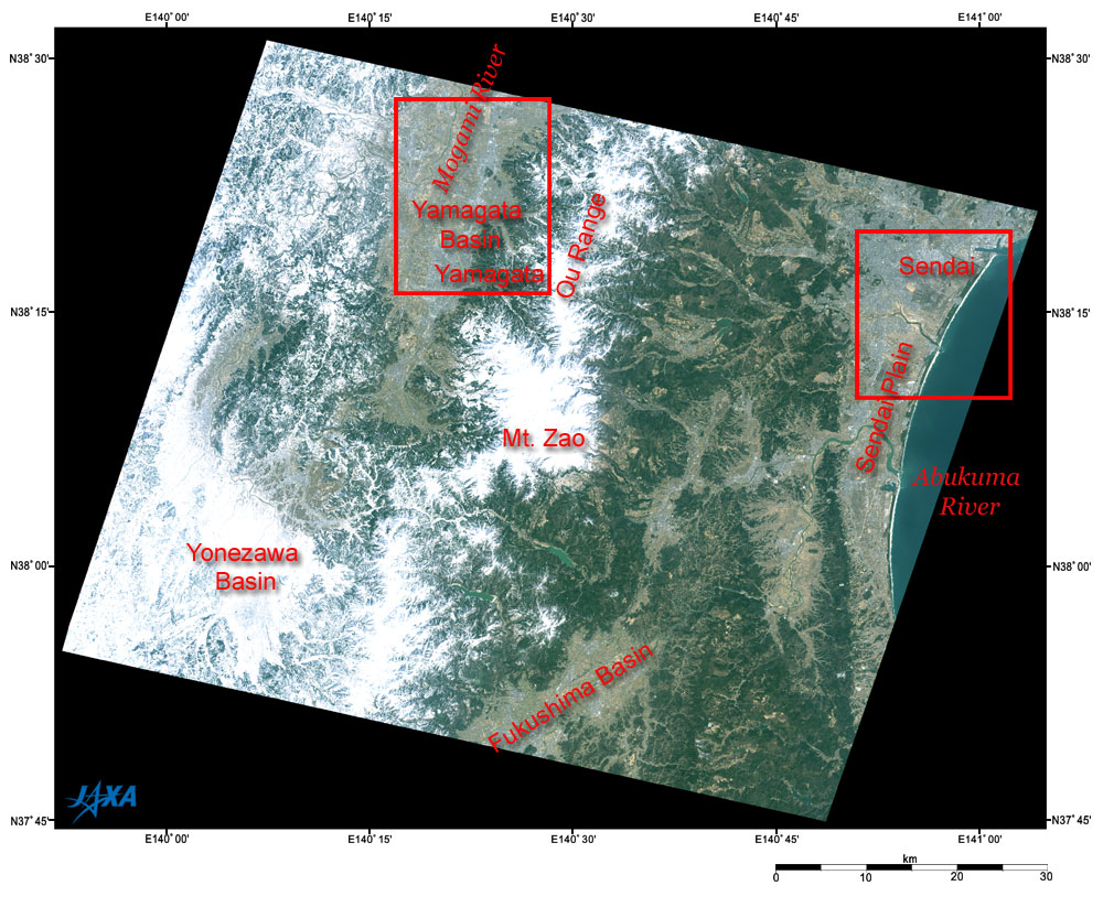
| Fig. 1. Zao and vicinity |
Figure 1 depicts Zao and its vicinity as observed by the Advanced Visible and Near Infrared Radiometer type-2 (AVNIR-2) aboard the Advanced Land Observing Satellite (ALOS), also called "Daichi." Mt. Zao (1,841 m above sea level), in the center of the figure, is on the border between Miyagi and Yamagata Prefectures. It is covered with snow. The Ou Range containing Mt. Zao extends north and south is also covered with snow. On the right of the figure is dark-blue Sendai Bay that connects to the Pacific Ocean. The urban areas of Sendai northeast of Zao and those of Yamagata northwest of Zao look bluish gray. The dark brown areas represent forests. The hazel indicates grasslands, farmlands or rice paddies. The Abukuma River flows northeastward from the Fukushima Basin into Sendai Bay. The Mogami River that goes north within the boundaries of the snow covered Yonezawa Basin changes direction to the east and goes north within the Yamagata Basin. The dam lakes in the Ou Range are dark green.
 |
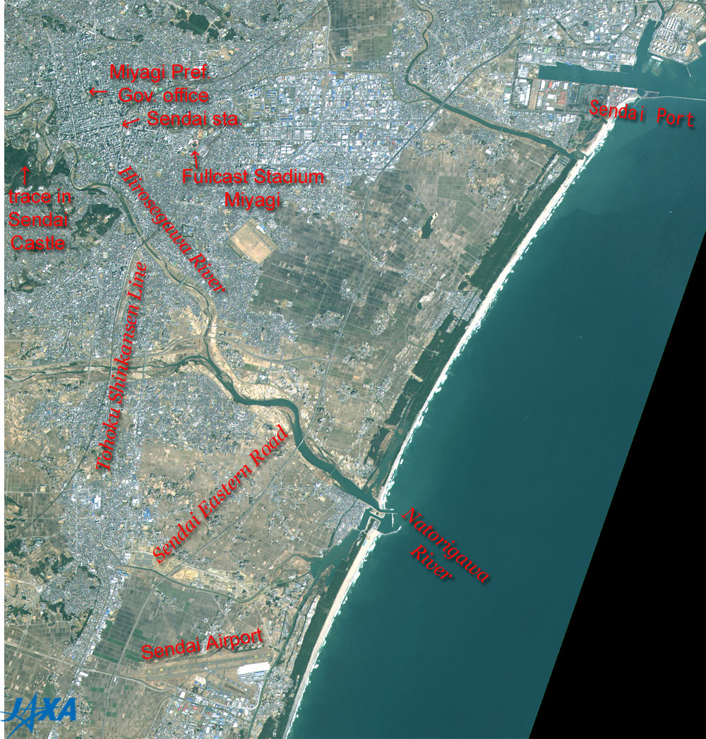
Fig. 2. Sendai and vicinity
Sendai (kmz, 5.68 MB, Low Resolution) as seen on Google Earth. |
Figure 2 is an expanded image of Sendai and its vicinity. Sendai Port is in the upper right and Sendai Airport is in the lower left. The road extending east links Sendai port and the airport. Paralleling the road on the westside, the Tohoku Shinkansen Line extends in the north and south direction, and crosses the Natorigawa River and its branch, the Hirosegawa River. The city area of Sendai is in the upper left of the figure. There seems to be minute unevenness around the Sendai station indicating that there are many tall buildings. Among these buildings, the Miyagi Prefecture Government office is casting its shadow in the upper left side. You can also see, east of Sendai station, Fullcast Stadium Miyagi, which is the home of the Tohoku Rakuten Golden Eagles (a Japanese professional baseball team).
To the west of Sendai station is the remains of Sendai Castle, which Masamune Date built in 1601 on Mt. Aoba. Sendai Castle is one of the Hira-yamajiro (the castle built on the hill in the plain). The meandering Hirose-gawa River was used as a crude outer moat. This castle was the residential castle of the Date family that served as seigneurs in the Sendai feudal clan through the Edo era (1603 - 1867) for many generations.
 |
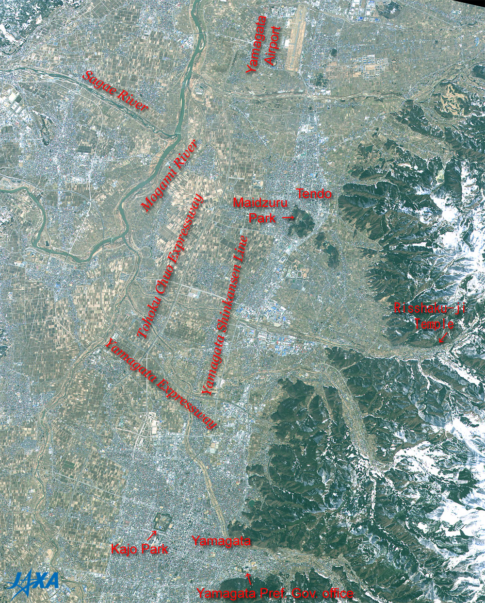
Fig. 3. Yamagata and vicinity
Yamagata (kmz, 8.29 MB, Low Resolution) as seen on Google Earth. |
Figure 3 is an expanded image of Yamagata and its vicinity. Yamagata airport can be seen in the upper portion of the figure. The upper left area of the figure shows how the Sagae River joins the Mogami River approximately at right angles and flows to the north.
The Yamagata Shinkansen Line or Ou Line stretches through the city area in Yamagata, and the area in Tendo. However, the line does not appear as distinct as the Tohoku Shinkansen Line in Fig. 2, due to the fact that the Tohoku Shinkansen Line has an elevating structure in the plains with the double track. The Yamagata Shinkansen Line is one of the mini-Shinkansen existing old networks with a single line that has been improved and it runs on the mound in the plains, mostly between Yamagata and Shinjo through Tendo.
Tohoku Chuo Expressway runs concurrently on the westside of Yamagata Shinkansen Line, intersecting with the Yamagata Expressway that stretches in the northwest-southeast direction.
In the center of the city area of Yamagata, you can see Kajo Park with its square moat. This is the remains of Nino-maru of Yamagata Castle reconstructed on a large scale by Yoshiaki Mogami in 1601, and the Nino-maru moat (middle moat) can be seen. Yamagata Castle was a Hirajiro (castle built in the plain). The area including Sanno-maru reached 710,000 tsubo (2.35 million square meters), and it was proud of its national and eminent scale. During the Edo era, the government office of the Yamagata feudal clan was placed here.
Yamagata Prefecture government office can be seen east of Kajo Park. There is Risshaku-ji Temple famous as Yamadera (mountain temple) on the right of the figure. In Tendo City in the upper portion of the figure, you can see Maidzuru Park famous by the Ningen-shogi (shogi using 40 persons instead of 40 pieces), which is held every year during the season of Hanami (cherry-blossom viewing).
As of April 28, the on-orbit early checkout of Advanced Land Observing Satellite (ALOS) "Daichi" is moving ahead smoothly.
Explanation of the images:
(Fig .1 to Fig. 3 )
| Satellite: |
Advanced Land Observing Satellite (ALOS) (Daichi) |
| Sensor: |
Advanced Visible Near Infrared Radiometer type-2 (AVNIR-2) |
| Date: |
1044 (JST) on March 25, 2006 |
| Ground resolution: |
10 m |
| Map Projection: |
Universal Transversal Mercator (UTM) |
|
AVNIR-2 is an upgraded AVNIR instrument with high resolution flown on the Advanced Earth Observing Satellite (ADEOS). AVNIR-2 is equipped with a pointing function by which it can shift its observation area perpendicular to the ALOS's moving direction. The color composition was made by using three out of four AVNIR-2 bands: visible (610 to 690 nm, band 3) for red, visible (520 to 600 nm, band 2) for green, and visible (420 to 500 nm, band 1) for blue. As a result, the figures have a natural coloring. You can interpret these images as follows. |
| Dark green: |
Forests |
| Light brown: |
Grasslands, farmlands, rice paddies or dry riverbed |
| Gray: |
City area or roads |
| White: |
Snow |
| Greenish blue: |
Water surfaces (lakes, rivers or sea) |
| Black: |
No data |
|
 |
|