| |
 |
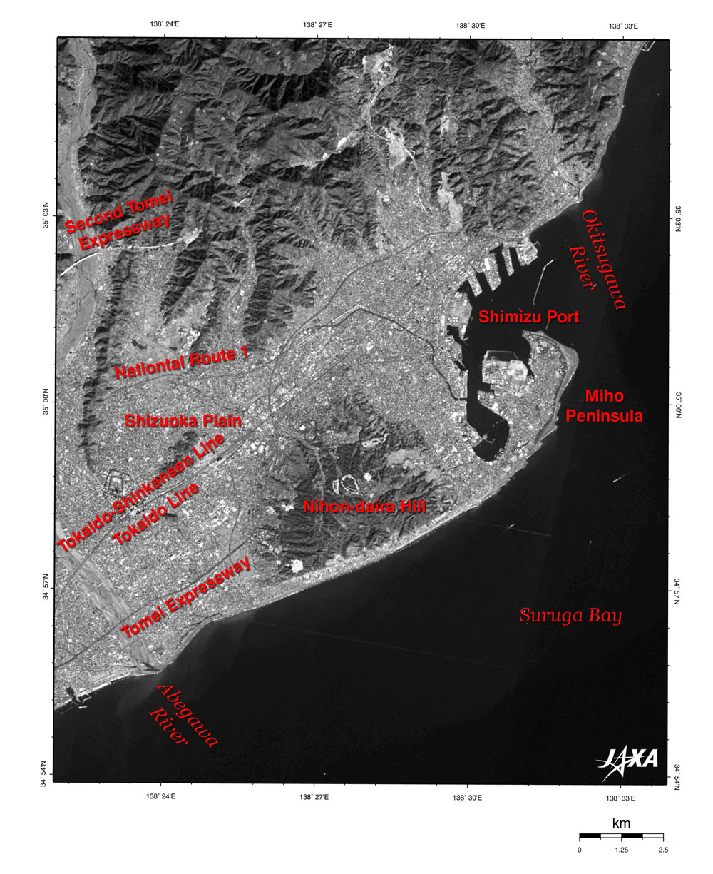
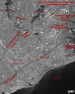
Fig. 1. The Area around Shizuoka City
Shizuoka (kmz, 4.28 MB, Low Resolution) as seen on Google Earth. |
The light-gray area at the center of Fig. 1 is Shizuoka Plain, the dark-gray land area is forest and the black area on the right is Suruga Bay. Abegawa River flows from the upper left of the figure southwards into Suruga Bay. When following Abegawa River from its mouth, we can see the Tomei expressway, which is the main arterial road linking Tokyo and Nagoya; the JR Tokaido and the Tokaido-Shinkansen Lines; and the second Tomei expressway under construction across the river. On the eastern side of the mouth of Abegawa River, the dark-gray arch of Nihon-daira Hill, the peculiar shape of the Miho Peninsula, and Shimizu Port and Okitsugawa River can all be seen.
 |
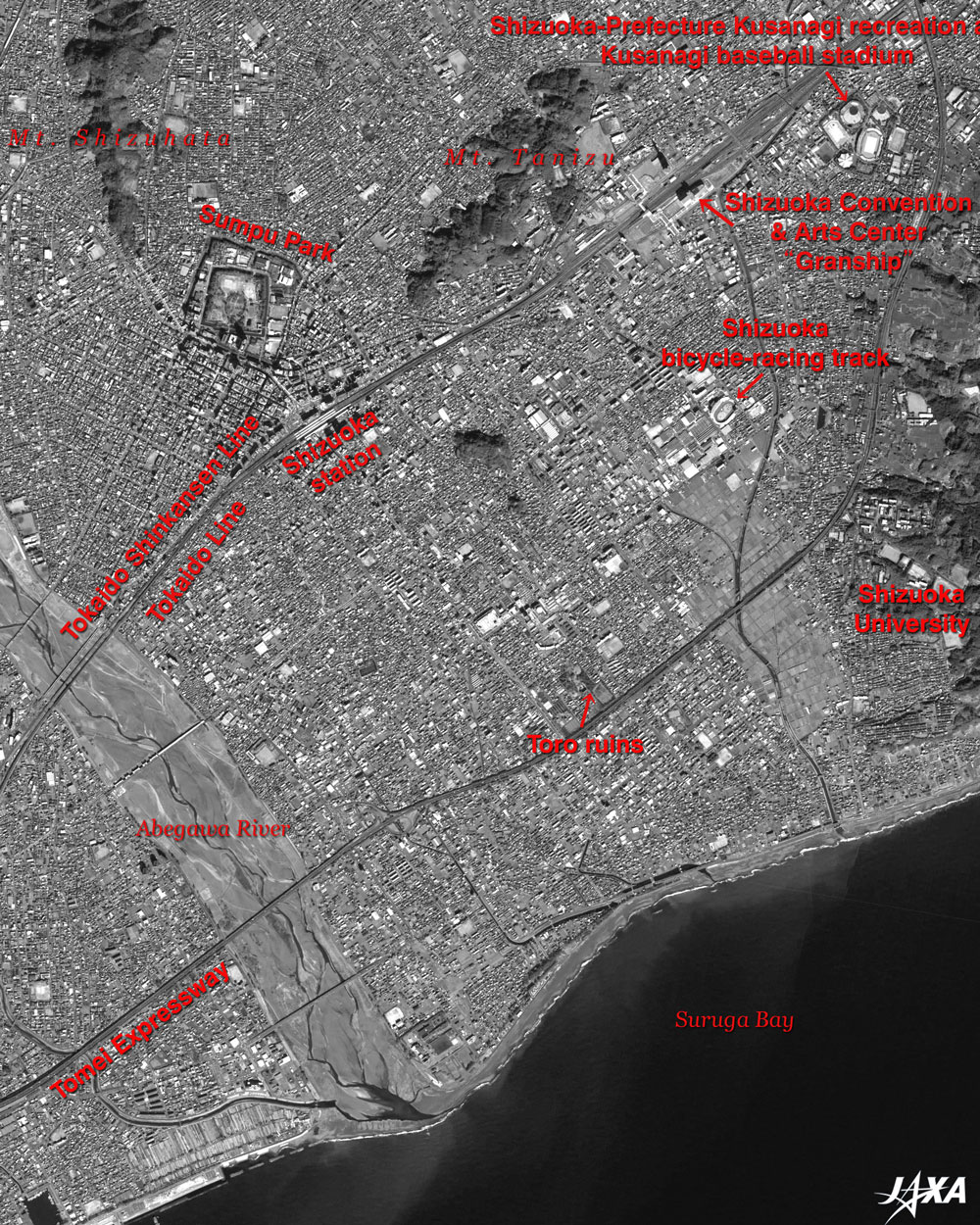
| Fig. 2. Expanded image of Shizuoka Plain |
Figure 2 is an expanded image of Shizuoka Plain. The dark-gray area in the upper left of the figure is Mt. Shizuhata, from which the name "Shizuoka" originates, and the double-square frame of the moat at Sumpu Park can be seen. The angle of the double moat is slightly askew, so it draws our attention. JR Shizuoka station is in the neighborhood southeast of Sumpu Park, and the Tokaido Shinkansen and Tokaido Lines extend in a northeast-southwest direction. The Tomei expressway lies in parallel with these lines. You can see the flood plain of the Abegawa River in the lower left of the figure. Just below the center of the figure, there are some Toro ruins containing the remains of dwellings, warehouses, and rice paddies that date back to the second and third centuries; corresponding to the latter period of the Yayoi Era. To the upper right of the ruins, you can see the ellipsoid Shizuoka bicycle-racing track, and the campus of Shizuoka University can be seen at the right edge of the figure. In the upper right of the figure, you can find the Shizuoka-Prefecture Kusanagi recreation area that contains Kusanagi baseball stadium, the athletic stadium, and the gym with the scalloped roof. The Shizuoka Convention & Arts Center, "Granship," can be seen along the tracks to the left of the playground.
 |
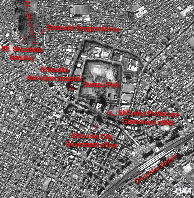
| Fig. 3. Expanded image centered on Sumpu Park |
Figure 3 is an expanded image centered on Sumpu Park. This park contains remnants of Sumpu Castle where Ieyasu Tokugawa, the founder and first shogun of the Tokugawa shogunate, lived from 1605 to 1616 in his final years. Sumpu Castle, which was modified and expanded just before his residence, was a typical multi-outlined "Hirajiro" or flatland castle. It was composed of the Hon-maru (the main citadel), the Nino-maru (the middle citadel) and the Sanno-maru (the outer citadel), having a threefold moat; from inside to outside, the Hon-maru moat (the inner moat), the Nino-maru moat (the middle moat), and the Sanno-maru moat (the outer moat). All of the buildings of the castle were demolished in 1872 at the beginning of the Meiji Era, and the inner moat was restored in 1896. The area of Sumpu Park is equivalent to the Hon-maru and the Nino-maru of Sumpu Castle. The restored Higashi-gomon (the east gate) and the Tatsumi Yagura (the southeast turret) can be seen at the southeastern end of Sumpu Park. There are many public facilities, including the Shizuoka Prefecture Government office in the old Sanno-maru area that is between the middle and outer moats. The Sumpu Yakata (mansion), the forerunner of Sumpu Castle constructed at the end of the 14th century, was located on the site of the present municipal hospital. You can see the Shizuoka City Government office in the area crossing the outer moat to the south of the Shizuoka Prefecture Government office. As high buildings generate dark shadows, in the upper left you can see that there are many high buildings near the Shizuoka-City Government office, and in the lower right around JR Shizuoka station.
The buildings at Shizuoka Sengen shrine can be seen at the southern foot of Mt. Shizuhata in the upper left. West of the shrine, you can find the Mt. Shizuhata tumulus, which is a round burial mound 32 m in diameter. This tumulus is thought to be the 6th century tomb of a once-powerful family.
As of April 25, the work of the on-orbit early testing of Advanced Land-Observing Satellite "Daichi " (ALOS) was progressing smoothly.
Explanation of the images:
Figs. 1 to 3
|
 |
|