| |
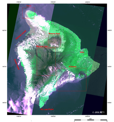 |
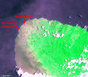
Fig. 1. The Island of Hawaii
Hawaii (kmz, 2.99 MB, Low Resolution) as seen on Google Earth. |
Figure 1 presents the largest island of the Hawaiian Islands, the Island of Hawaii (often called "The Big Island") as observed by the optical sensor aboard the Japanese Earth Resources Satellite (JERS-1). There are five volcanoes on this island, Mauna Loa, Mauna Kea, Kilauea, Fualalai, and Kohala, among which Mauna Kea (4,205 m) has the highest peak in the Pacific Ocean and its summit is one of the most suitable locations on Earth for astronomical observation. A total of 13 state-of-the-art visible, infrared, submillimeter, and radio telescopes are located here, and this area is known as the "Land of Observatories."
Although Mauna Loa is just 4,169 m above sea level, it is the largest volcano in the world because the height from the seabed, which sank under the weight of Mauna Loa itself, is about 17,000 m. Mauna Loa means "the Long Mountain" in Hawaiian, and its gray mountain ridge stretches more than 50km from northeast to southwest. Kilauea (1,234 m) is the world's largest active volcano, and is still expanding the size of this island. Hawaii Volcanoes National Park (including Mauna Loa and Kilauea) was added to "The World Natural Heritage" list in 1987, and it contains huge fern forests as well as rare birds and endemic species.
Kamehameha the Great was born in 1758 on the Kohala Coast in the northwestern part of this island, and he began his expedition of conquest and unification of the Hawaiian Islands from this seashore.
The famous Kona coffee is grown on farms along the Kona Coast in the southwestern part of the island. The southernmost end of this island, Kalae Cape (18° 56' North), is also the southernmost tip of the U.S. Hilo, in the northeastern part of the island, is the largest city (population 40,000) in the Island of Hawaii, where the Pacific Tsunami Museum is.
 |
 |
| Fig. 2a Mauna Kea |
Fig. 2b Summit of Mauna Kea |
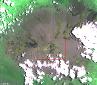
Figure 2a depicts an expanded view of Mauna Kea. The circumference of the mountain is covered with vegetation and is seen as green, but the summit of the mountain is gray, which means that there is little vegetation. The round, blackish geographical features are old volcanic craters. The fluffy white flocks are clouds, which cast their dark shadows toward their left.
Figure 2b presents an expanded image of the top of Mauna Kea. The domes and antennas of astronomical observatories, including the Japanese Subaru Telescope, are seen as white spots. The climate of the summit is quite stable, and the north-easterly wind (trade wind) blows year round. The air is dry and thin, and the sky is clear for more than 300 days of the year. Since it is located near the equator, all celestial objects of the Northern Hemisphere and most objects of the Southern Hemisphere are observable. As it is blessed with such ideal conditions, it is one of the most suitable locations for astronomical observation on the planet.
 |
 |
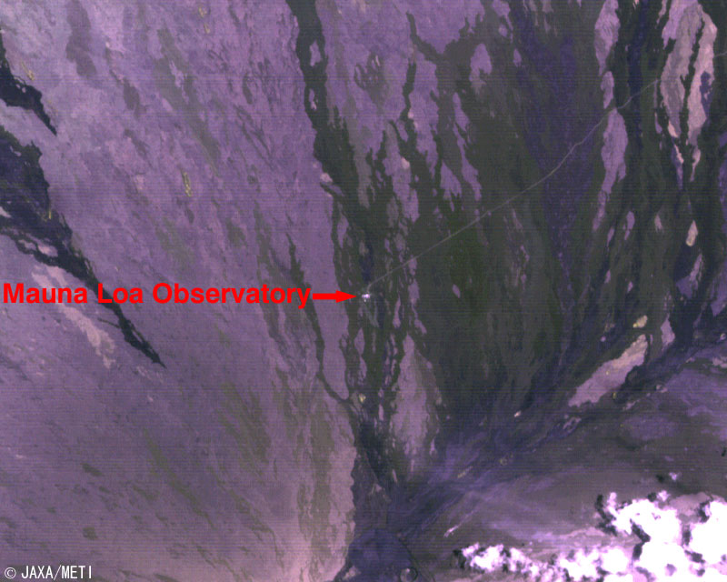
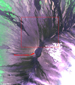
| Fig. 3a Mauna Loa |
Fig. 3b Northern flank of Mauna Loa |
Figure 3a presents an expanded view of the Mauna Loa summit area. The huge blackish caldera with a major axis of 4.5km and a minor axis of 2.7km is seen at the center of the image. The purple or black area is lava, and the many black lines are traces of recent lava flows.
Figure 3b is an expanded view of the northern flank of Mauna Loa. The white spot is the Mauna Loa Observatory of the U.S. National Oceanic and Atmospheric Administration (NOAA) where observation of the atmospheric carbon dioxide, known as the major cause of the global warming, has been continuously monitored since 1958. Since the Hawaiian Islands are far from any continents, it is thought that the atmospheric carbon dioxide level observed here indicates the average value of the Earth's atmosphere rather than a locally biased value. The observation results, which are provided to the rest of the world, reveal that the carbon dioxide levels have risen at the alarming rate of 15% over the last 40 years.
 |
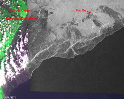 |
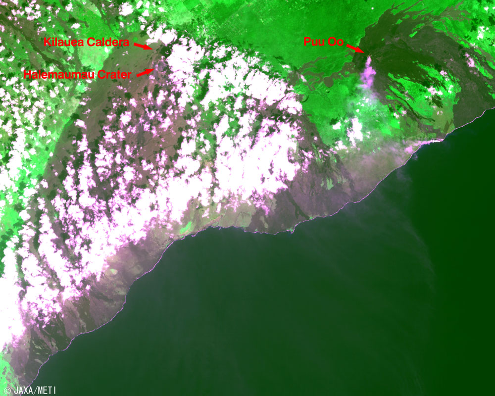
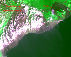
Fig. 4a Kilauea
(Optical-Sensor Image) |
Fig. 4b Kilauea
(Synthetic-Aperture Radar Image) |
Figure 4a depicts an expanded view around the Kilauea volcano as observed by the optical sensor. The dark purple-red areas are the slopes toward the sea, which indicate that the surface of this portion is covered with lava flow. The many white clouds seen above the lava area are large amounts of steam evaporating from the hot lava.
The monochrome portion of Fig. 4b is the synthetic-aperture radar image where the huge Kilauea caldera (4.5 km (major axis) by 3 km (minor axis)) and many dotted craters can be seen. At the southwestern end of this caldera, is the 1km diameter Halemaumau crater, where the goddess of fire "Pele" was once thought to have lived. The last eruption was in 1974, but now it is considered to be in a dormant state, and the active area has now moved to the eastern side. The Puu Oo crater, from which smoke can be seen in Fig. 4a, is now the center of activity.
 |
| Fig. 5. Northern Kohala Coast |
Figure 5 provides an expanded view of the northern Kohala Coast and the northernmost end of the Island of Hawaii. Here is the birthplace of Kamehameha the Great. It is surrounded with a stone wall which stands a little westward from Mookini Heiau*1. There is a stone named "Kamehameha -Akahi-Ina-Hanau" on which it is said Kamehameha was born. It is also said that Kamehameha the Great's ashes were buried somewhere on the Kohala Coast. As legend goes, special Mana*2 is believed to reside within a great king's bones, but the actual location remains a mystery.
Explanation of the images:
(Fig. 1 to Fig. 5)
| Satellite: |
Japanese Earth Resources Satellite-1 (JERS-1) (Fuyo-1) |
| Sensor: |
Visible and Near Infrared Radiometer (VNIR),Synthetic-Aperture Radar (SAR)
|
| Date: |
January 24, 1993, July 24, 1996 (VNIR),July 2, 1997 (SAR) |
| Ground Resolution: |
18.3 m x 24.2 m (VNIR),18m (SAR)
|
| Map Projection: |
Universal Transversal Mercator (UTM) |
| The composite figures were produced by assigning green to the near-infrared channel (760 to 860 nm), red to the visible channel (630 to 690 nm), and blue to the visible channel (520 to 600 nm). The resulting figures have natural coloring of dark green for vegetation, light green for grasslands, grey or dark purple-red or black for lava, white or purplish white for cloud, and blackish for sea surface, appearing as if seen by the naked eye. In addition, the right end-portion was colored green in the monochrome picture by SAR (observation frequency: 1,275 MHz (L band)). Areas with no data are black. |
|
 |
Related Site:
 Land, Seen from Space Land, Seen from Space
Appendix:
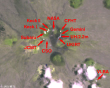
Why the summit of Mauna Kea became the Land of Observatories:
The Hawaiian Islands often suffered major damage from tsunamis. Hilo, the largest town of the Island of Hawaii, was struck by the tsunami created by the Aleutian Earthquake in April 1946 and also suffered serious damage from the tsunami of the Chile Earthquake in May 1960. One of the ideas for the economic restoration of the town was to establish astronomical observatories on Mauna Kea. Not only is this the best location on Earth for astronomical observation, but local assistance was also offered, and the following telescopes were constructed. However, additional construction is not foreseen in order to protect sacred places and the environment of Mauna Kea.
| 1968: |
University of Hawaii 60cm Telescope (UH/0.6 m: The first telescope on the summit, still in-service.) |
| 1970: |
University of Hawaii 2.2m Telescope (UH/2.2 m: NASA and University of Hawaii collaboration) |
| 1979: |
NASA Infrared Telescope Facility (IRTF, 3.0 m)
Canada-France-Hawaii Telescope (CFHT, 3.6 m)
United Kingdom Infrared Telescope (UKIRT, 3.9 m) |
| 1987: |
California Institute of Technology Submillimeter Telescope (CSO 10.4m, Caltech/NSF)
James Clark Maxwell Radio Telescope (JCMT, 15 m, UK/Canada/Netherlands)
|
| 1992: |
U.S. National Radio Astronomy Observatory (NRAO) Very Long Baseline Array (VLBA) (25 m parabolic antenna)
W.M. Keck Observatory (Keck-I Telescope, 10m, Caltech/University of California) |
| 1996: |
W.M. Keck Observatory (Keck-II Telescope, 10m, Caltech/University of California) |
| 1999: |
Gemini Northern Telescope (8.1 m, USA/UK/Canada/Argentina/Australia/Brazil/Chile)
Subaru Telescope (8.3 m, Japan)
|
| 2002: |
Submillimeter Array (8x6 m, Smithsonian Astrophysical Observatory/Taiwan) |
Keeling Curve:
The graph of the atmospheric carbon dioxide density observed at Mauna Loa reveals a constant increase with fine seasonal variation of a one-year cycle. This curve is called "Keeling Curve." after Dr. Charles D. Keeling, Scripps Institution of Oceanography, who first discovered this fact.
|
|