Seen from Space 2006
ALOS (Daichi) observes Landslide in Leyte Island, Philippines
| |
 |
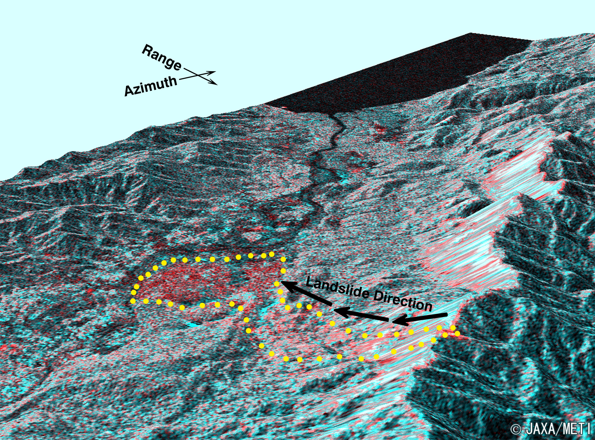
Bird's-eye view of the landslide stricken area composed
with red-coloerd image by the PALSAR aboard ALOS
and green-blue colored
image by SAR aboard JERS-1
Guide map of Leyte Island is here.
|
The Phased Array type L-band Synthetic Aperture Radar (PALSAR) and the Advanced Visible and Near Infrared Radiometer type-2 (AVNIR-2) aboard the Advanced Land Observing Satellite (ALOS) "Daichi" observed landslide in the Leyte Island, Philippines. We could estimate that the landslide sediments expand approximately 1.5 km in maximum width and 3.9 km in length and that a collapse of approximately 100 m in height occurred at the ridge. This is a result of our analysis by comparing post-disaster image by PALSAR and pre-disaster image by the Synthetic Aperture Radar (SAR) aboard Japanese Earth Resources Satellite-1 (JERS-1) on February 2, 1996. Please refer to the ALOS New-Arrived Images page.
JAXA provided the observed image data and analyzed image data to the following organizations.
International Charter "Space and Major Disasters"
Asian Disaster Reduction Center (ADRC)
Explanation of the image:
| Satellite: |
Advanced Land Observing Satellite (ALOS)(Daichi) |
| Sensor : |
Phased Array type L-band Synthetic Aperture Radar (PALSAR) |
| Date: |
1054 (JST) on February 24, 2006 |
|
The PALSAR is an upgraded Synthetic Aperture Radar (SAR) onboard the Japan Earth Resources Satellite-1 (JERS-1) with improved function and performance. It is an active type microwave sensor, which can carry our observations day and night regardless of weather conditions. The PALSAR is equipped with a function to change its observation direction and observation mode to cover wider range (Scan SAR.) The radar is developed in cooperation with the Japan Resources Observation System Organization (JAROS) of the Ministry of Economy, Trade and Industry (METI.) |
| Satellite: |
Japanese Earth Resources Satellite-1 (JERS-1)(Fuyo-1) |
| Sensor : |
Synthetic Aperture Radar (SAR) |
| Date: |
1012 (JST) on February 2, 1996,December 1996 (Guide map) |
|
The SAR is an active type microwave sensor, which can carry our observations day and night regardless of weather conditions. The SAR was developed in cooperation between the Japan Resources Observation System Organization (JAROS) of the Ministry of Economy, Trade and Industry and NASDA (present JAXA). |
|
 |
|