| |
 |
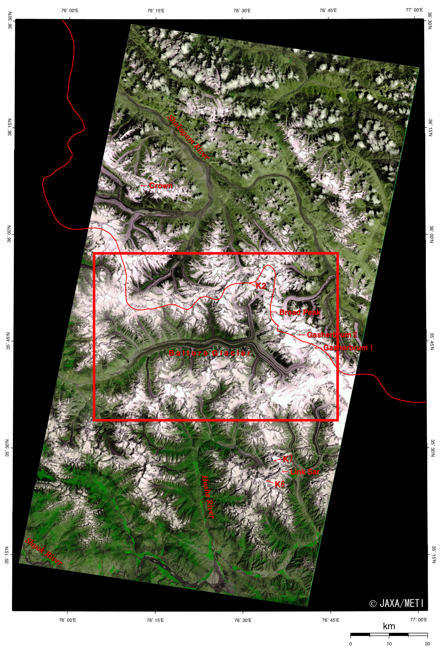
| Fig. 1. Eastern Karakoram Range |
Figure 1 depicts the world's second highest mountain, K2 (8,611m), as well as Broad Peak (8,051m), Gasherbrum I (8,068m), Gasherbrum II (8,035m), and more than twenty other peaks of approximately 7,000 meters in the Karakoram Range, as observed by the optical sensor aboard the Japanese Earth Resources Satellite-1 (JERS-1). The Baltoro Muztagh (mountain group) is on the northern side of Baltoro Glacier, flowing from east to west in the center of the figure. The Masherbrum Range is on the southern side. The high-altitude areas are covered with snow and ice and appear as white or light purple. The exposed rock surfaces are black, as are the cloud shadows on the steep mountainsides. The sun shining from the lower right causes dark shadows on the upper left. The figure covers the border area between Pakistan and China, which extends mainly along the convoluted ridge of these mountains. China lies to the north (Xinjiang Uighur Autonomous Region) and Pakistan lies to the south (the part of Kashmir controlled by Pakistan).
Small clouds hang near the top of the figure. The major areas at low altitude (though still above 3,000m) are light green, representing grassland. The Shaksgam River that flows to the upper left at the top of the figure flows northward through breaks in the Kunlun Cordillera (outside the figure), then into the Taklimakan desert, and finally disappears. Strong green forests and lush grasslands appear as vivid green at the bottom of the figure. The Hushe River, which flows southward at the bottom of the figure, joins the Shyok River and then the Indus River. The metropolis of Islamabad is approximately 400km southwest of K2.
 |
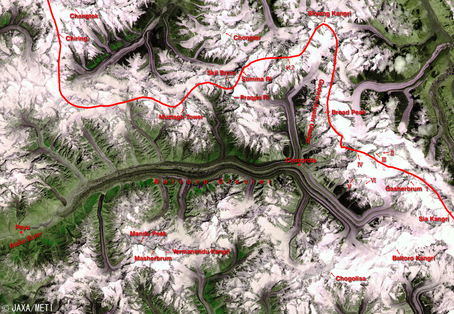
| Fig. 2. Extended Image of the Center of Fig. 1 |
Figure 2 is an expanded image of the center of Fig. 1. In the eastern area, along the border from K2 in the upper right, are the 8,000m and the 7,000m peaks such as Skyang Kangri (7,357m), Broad Peak (8,051m), Gasherbrum IV (7,925m), Gasherbrum III (7,952m), Gasherbrum II (8,035m), Gasherbrum I (8,068), Gasherbrum V (7,133m), Gasherbrum VI (7,004m), and Sia Kangri (7,422m). Chongtar (7,330m) is west-northwest of K2. To its west along the border as seen from K2, it is followed by Summa Ri (7,286m), Skilbrum (7,360m), Praqpa Ri (7,156m), Muztagh Tower (7,284m), and after crossing the glacier, Chiring (7,090m) and Changtok (7,045m).
Baltoro Glacier, at the center of Fig. 2, is the third largest glacier in the Karakoram Range, 61km long and 530km wide. Numerous branch glaciers flow into Baltoro Glacier from the Baltoro Muztagh and the Masherbrum Range. Trekking courses are set up there, and it takes three days for a one-way trip from Payu (3,785m) near the tip of the tongue of the Baltoro Glacier, to reach Concordia (4,691m) where you can see K2 and Gasherbrum IV.
Mandu Peak (7,127m), Masherbrum (7,821m) and Yermanendu Kangri (7,163m) are on the southern side of the lower reach of the Baltoro Glacier. On the southern side of the upper stream are Chogolisa (7,668m) and Baltoro Kangri (7,300m). The source head of Baltoro Glacier is on the northeastern side of Chogolisa. Crown (7,295 m), on the upper left in Fig. 1, is not seen in Fig. 2. Neither are K6 (7,281m), Link Sar (7,041m), or K7 (6,938m).
The growth and melting of glaciers are indices for measuring global warming. Glaciers are easily affected by global warming at relatively low latitudes, but some reports show that they are also affected at high altitudes, as in the Himalayas and Tibet. As glaciers retreat and contract, glacial lakes collapse, flooding downstream areas and causing sea levels to rise. Continued careful observation is therefore essential.
Reference:
Himalaya Meihou Jiten (in Japanese), Heibonsha Ltd., 1996
|
Explanation of the images:
(Fig. 1 and Fig. 2)
| Satellite : |
Japanese Earth Resources Satellite-1 (JERS-1) |
| Sensor: |
Visible and Near Infrared Radiometer (VNIR) |
| Date: |
0557 (UT) on September 16, 1995 |
| Ground resolution: |
18.3m x 24.2m |
| Map Projection: |
Universal Transversal Mercator |
| We produced the figure by assigning red to the visible channel (0.63 to 0.69µm), green to the near-infrared channel (0.76 to 0.86µm), and blue to the visible channel (0.52 to 0.60µm). The resulting figure has natural coloring, with vegetation slightly emphasized and snow and ice looking purplish, yet still appearing as though seen with the naked eye. In this image, snow and ice are white or pale purple, forests are dark green, grasslands are olive green, and water surfaces and areas with no data are black. |
|
 |
Related sites:
 Dhaulagiri, Himalayas: Eight-Thousand-Meter Peak and Glaciers (Part 3) Dhaulagiri, Himalayas: Eight-Thousand-Meter Peak and Glaciers (Part 3)
Northern Pakistan
Cho Oyu, Himalayas: Eight-Thousand-Meter Peak and Glaciers
Eight-Thousand-Meter Peak and Glaciers: Shishapangma, Himalayas
Land, Seen from Space
Appendix: Origin of mountain naming
According to the reference, "Gasherbrum" means "shining peak" or "shining wall" in Balti, the language of Baltistan. Therefore, this name should be originally given to the fourth peak situated in front of Baltoro Glacier, but it became the name of the whole group of mountains according to the reference.
The letter "K" in K2, K6, and other mountain names, is the initial of the Karakoram Range. K2 means the second measured peak, and it was used as one of the survey-control peaks in the Karakoram Great Trigonometric Survey started in 1856. Similarly, K6 means sixth measured peak. After that, whenever there was an existing local name, that was adopted, but in the absence of a local name the peaks were called K2, K6, and so on. K1 corresponds to Masherbrum, K3 to Gasherbrum IV, K4 to Gasherbrum II, and K5 to Gasherbrum I.
|
|