| |
 |
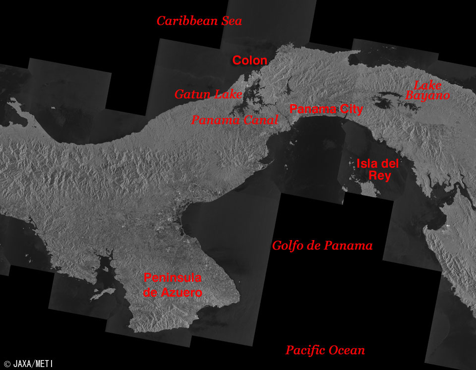
| Fig. 1 Major Part of the Republic of Panama |
Figure 1 depicts the major part of the Republic of Panama observed by Synthetic Aperture Radar (SAR) aboard the Japanese Earth Resources Satellite-1 (Fuyo-1). The Caribbean Sea, which connects with the Atlantic Ocean, is at the top of the figure in black, and the Gulf of Panama, which flows into the Pacific Ocean, is at the bottom in black. The east side of Panama touches Colombia in South America, and the west side touches Costa Rica, which connects to the North American Continent. The Panama Canal was opened to traffic in 1914 after excavation of the narrowest place on this isthmus that links North and South America.
The image indicates the strength of the SAR-transmitted radio signal as it is scattered backward by the Earth's surface. Calm water surfaces that tend to scatter forward radio signals look black, while urban areas and artificial structures that reflect backward radio signals well look bright, and the forests in the middle appear gray. This is a powerful demonstration of SAR's ability to observe the Earth's surface regardless of clouds, because Middle America containing Panama is in a hot and humid tropical climate zone that is usually covered by clouds.
 |
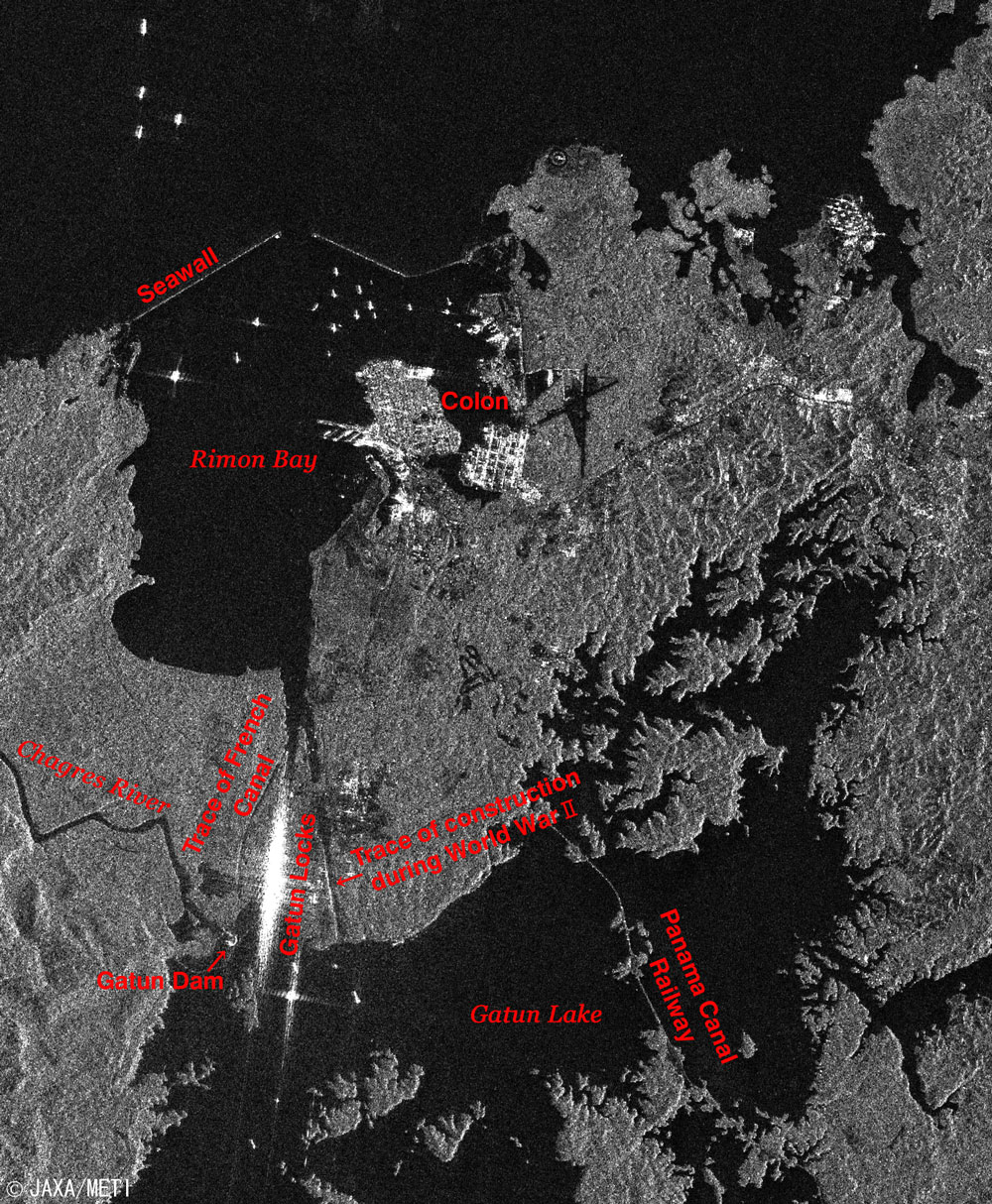
| Fig. 2 The Panama Canal |
Figure 2 is an expanded image of the Panama Canal and its vicinity from Fig. 1. The city area of Colon embraces a free trade harbor on the Caribbean Sea, and the ships inside and outside of a pair of seawalls and the Gatun Locks look bright. On the Pacific Ocean side, metropolitan Panama City looks bright.
The Panama Canal extends in a northwest - southeast direction over 78 km (from one marking buoy to another), starting near Colon on the Caribbean side to near Panama City on the Pacific Ocean side, via artificial Gatun Lake at 25.9 m above sea level and artificial Miraflores Lake at 16.5 m above sea level. There are three sets of locks: Gatun Locks on the Caribbean side and Pedro Miguel Locks and Miraflores Locks on the Pacific Ocean side. This is to adjust for differences in water levels along the route and is largely different from the sea surface type adopted in the Suez Canal. This is because the average sea level on the Pacific Ocean side in the Panama Canal is 24 cm higher than that on the Caribbean side, the tide changes more than ± 3.2 m on the Pacific Ocean side, there is a 60 cm tide change on the Caribbean side, and ships must also pass through the two above-mentioned lakes that are above sea level.
Gatun Lake is an artificial lake formed by stopping the Chagres River at Gatun Dam. The Alajuela Lake (Madden Lake) at the center right of Fig. 2, another artificial lake was formed by stopping the upper stream in the Chagres River at Madden Dam, supplies fresh water to control the water level.
The quantity of water necessary for one large-ship to pass through the Panama Canal is about 200,000 tons and is discharged from Gatun Lake via the locks to the sea. Miraflores Lake is located between Pedro Miguel Locks and Miraflores Locks.
The narrowest place in the Panama Canal is Culebra (Gaillard) Cut, extending 13.7 km from the northern end of Pedro Miguel Locks to the point where it joins the widened Chagres River, and bending because it was constructed by opening rocks in the watershed.
Portobelo, located about 30 km northeast of Colon, and San Lorenzo on the mouth of the Chagres River about 10 km southwest of Colon were added to the list of UNESCO's World Cultural Heritage sites in 1980 as "Fortifications on the Caribbean side of Panama: Portobelo-San Lorenzo."
You can see Panama City's Tocumen International Airport in black in the lower right.
 |
| Fig. 3 Expanded image around Colon |
The bright spot at the center of Fig. 3 is the city area of Colon. The ships apparently anchored inside and outside Limon Bay, look bright. The very bright area in the lower left is Gatun Locks. This probably happens because two walls and the surface of the water inside the lock chambers form corner cubes like a solid corner, and they reflect the SAR radio signal straight back.
There are a trace of the French canal led by Lord Lesseps, the Chagres River, and the Gatun Dam in the west of Gatun Locks. There is also a trace of the construction by the U.S. during World War II just east of Gatun Locks.
You can see the Panama Canal Railway crossing Gatun Lake. It started in 1855 as the crossing railway that links Colon and Panama City, was discontinued once in 1997, but was reopened in 2001.
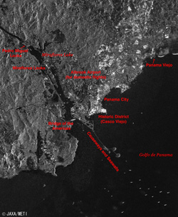 |
| Fig. 4 Expanded Image around Panama City |
The bright area at the center of the figure is Panama City, and the black stripe extending from the west of the city and northwestward is the Panama Canal. If you examine the areas at Pedro Miguel Locks and the Miraflores Locks in the upper left, you can find the partition between two lines of lock chambers. The size of each chamber placed between two locks is 33.53 m wide and 304.8 m long, and the maximum size of the ship that can be handled by this lock chamber is 32.3 m wide and 294.1 m long. Additionally, the ship must be able to float in tropical fresh water 12 m in depth. This size of a ship is called "Panamax" and is equivalent to the classes from 50,000 to 80,000 tons.
A spindly ditch parallels the original canal on the west side of the original canal and on the southern side of Miraflores Locks. This is called the Third Lock Excavation; its construction was interrupted when World War II broke out.
The Bridge of the Americas crossing the mouth of the Panama Canal looks bright. There are causeways and seawalls that link three islands and a mainland in the lower right. The ships, apparently anchored, appear as bright dots at the end of the causeways.
The Albrook Airport for domestic flights looks black in the west of central Panama City. Panama Viejo northeast of the central city area and the Historic District (Casco Viejo) in the south were both added to the list of UNESCO's World Cultural Heritage sites as "Archaeological Site of Panamá Viejo and Historic District of Panamá " in 1997.
French Lord Lesseps, who was responsible for the successful construction of the Suez Canal in 1869, set about the construction of the Panama Canal in 1880. However, the project was beset by technical difficulties, the heavy loss of laborers to malaria and yellow fever, and funding stalemates due to the unexpectedly prolonged construction, and construction finally stopped in 1889. Later, the US took it over, construction was resumed in 1904, and the canal opened to traffic in 1914. The US leased the Canal Zone from Panama and managed the Panama Canal beginning in 1904, but returned them to Panama on December 31, 1999. Since then, the Panama Canal Authority has been managing the canal.
Explanation of the images:
Figs. 1 to 4
|
 |
Related Sites:
 The Suez Canal: A shortcut for ships through the desert The Suez Canal: A shortcut for ships through the desert
The JERS-1 SAR Global Forest Mapping (GRFM/GBFM) Program
Appendices:
The Shortcut Effect:
The route between New York and San Francisco is 11,300 nautical miles (21,000 km) via Cape Horn off the southern tip of South America and the Drake Passage, but it is 4,600 nautical miles (8,500 km) via the Panama Canal; 60% shorter. Navigating at 20 knots, it takes 24 days via Cape Horn, but only 11 days via the Panama Canal. One nautical mile (n.m.) =1,852 m = length of one minute of the meridian, and 1 knot =1 n.m. / hour.
The Expansion Project:
The narrow Culebra Cut was a bottleneck to passage in the Panama Canal, and large ships were compelled to take turns navigating the one-way lane. However, since widening construction was completed by November 2001 and the navigation support was modernized, the Panamax ships have been able to safely traverse the canal bi-directionally and simultaneously 24 hours a day.
The pass time averages approximately 20 hours including the waiting time and is 5 hours longer than that in the Suez Canal. The water level must be adjusted six times at three locks, and tugboats and electric locomotives must assist large ships entering and exiting each lock chamber.
It is operated throughout the year. The Panamax ships currently account for one-fourth of the passing ships, but that ratio is projected to increase to one-third in 2010. A plan to develop new locks is under review to provide the ability to accommodate the 150,000-ton class ship or more, which is more than twice the size of the present Panamax ship.
The Passage Volume:
About 13,000 to 14,000 ships pass through the Panama Canal each year. This corresponds to 5% of the world's marine transportation. Thirty-nine percent of the ships are container ships, followed by 20% dry bulk carriers, 15% vehicle carriers, 9% tankers, 7% refrigerated cargo ships, etc. (based upon aggregate tonnage as of 2004). Except for a similarly large ratio of container ships, the variety and wealth of the ships differs from those through the Suez Canal. Travel from the east coast of the US to Asia makes up 35% of the trade routes, the trip around the world is 9%, Europe to the west coast of South America is 8%, the east coast of US to the west coast of South America is 7%, Europe to Asia is 5%, and so on.
According to the Panama Canal Authority, the annual passing fees in 2004 totaled 758 million dollars (83.4 billion yen), a record-high, and it is an important source of income for Panama.
The Important Point of the Traffic, Panama:
Explorers from Spain visited Panama at the beginning of the 16th century. In 1513, Balboa reached the Pacific Ocean side and found that Panama is the narrowest place on the isthmus that divides the Atlantic and the Pacific Oceans. At that time, Balboa saw the quiet sea and named it "the Pacific Ocean." Panama's strategic location was an important factor in the conquest of the Incas in the 1530s. Goods such as silver were transported by sea from Peru and the nearby colonies to Panama City on the Pacific Ocean side, overland to Portobelo on the Caribbean side, and continued north to Spain by sea.
In the middle of the 19th century, the US was engrossed in the Gold Rush on its west coast. To travel back and forth between its east and west coasts, it was actually more efficient to sail to Panama, ride the Panama Railway that opened to traffic in 1855 to cross to the opposite side, and continue to the Continental United States by sea than it was to take the more direct route, which meant crossing the Rocky Mountains by stagecoach. This situation continued until the introduction of the Transcontinental Railroad in 1869 and led to the strong interest in the Panama Canal by the US.
Takashi Aoyama:
Takashi Aoyama was the only Japanese engineer involved in the design of Gatun Locks during the construction of the Panama Canal from 1904 to 1911, following his graduation.
After returning to Japan, he designed Iwabuchi Locks on the Arakawa River in 1915, and he applied his technological experience to the repair of the Arakawa River and excavation construction of the Arakawa bypass that began in 1918.
|
|