Seen from Space 2005
Heavy rainfall brought by Baiu front hit Chugoku area
| |
 |
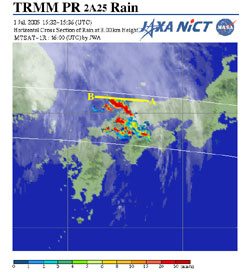 |
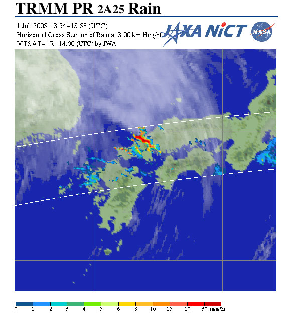
| Fig. 1a 2257 (JST) on July 1, 2005 |
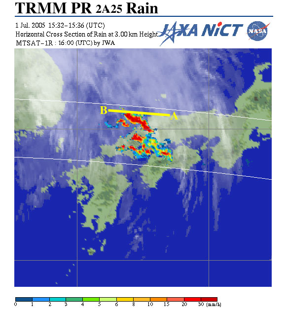
Fig. 1b 0033 (JST) on July 2, 2005 |
Fig. 1 Rain rate distribution and cloud image
of rain storm
over Chugoku area |
Heavy rain fell intermittently over the Chugoku and Shikoku areas in Japan from 1 July to 3 July 2005. Brought by an intrusion of warm and humid air from the south to the Baiu front over the Japan Islands, rainfall exceeded 250 mm during the two days. Flooding occurred and evacuation instructions were issued in many places.
Figure 1 depicts the cloud and rainfall distributions at 3 km height over the Chugoku area around 2257 (JST) on July 1, 2005 (Fig. 1a) and 0033 (JST) on July 2, 2005 (Fig. 1b) captured by the Precipitation Radar (PR) of the Tropical Rainfall Measuring Mission (TRMM) satellite and MTSAT-1R (Himawari-6). Linear rainbands extend from northwest to southeast over Yamaguchi, Shimane, and Hiroshima Prefectures. Although the rainbands are not large, there are many red areas in the bands, and well-developed cumulonimbi clouds brought strong rainfall over the narrow areas. The rainbands moving eastward developed in one and one-half hours. Heavy rainfalls of 74 mm from 0100 to 0200 and 128 mm from 0000 to 0300 were observed in Oda, Shimane Prefecture.
 |
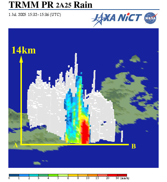
| Fig. 2 Three-dimensional structure of rainfall with vertical cross sections of rainfall rates seen from north |
Figure 2 depicts a three-dimensional structure and a vertical cross-section of the storm along the line A-B in Fig. 1b. The top of the precipitation reached 14 km height. Although the rain area was small, it was extremely well developed with a strong updraft.
|
|
| Fig. 3 Bird's-eye view of rainfall seen from the west of Kyushu |
The three-dimensional rain structure with moving cross-sections in Fig. 3 exhibits the well-developed rain with high rain top height along the narrow rainbands.
Because the Baiu front stayed on the southern side of Japan, rainfall in the Okinawa area in 2005 exceeded the normal rainfall during the Baiu season. Meanwhile, rainfall in the Japan Islands was low, especially on the western side of Japan in the early Baiu season, and the beginning of the Baiu season in the Hokuriku area was delayed. This strong rain storm brought much rain and alleviated fears of a water shortage and drought in June. In July, the Baiu front stayed over the Japan Islands and the amount of rainfall rapidly increased. A heavy rainfall event occurred in the Niigara area, as well as in western Japan. This shows that the 2005 Baiu season was typically positive.
Explanation of the images:
|
|
*Cloud image was acquired by MTSAT-1R (Himawari-6) and was provided by JWA
*1 TRMM is a joint mission between NASA, NICT and JAXA.
|
|