| |
 |
 |
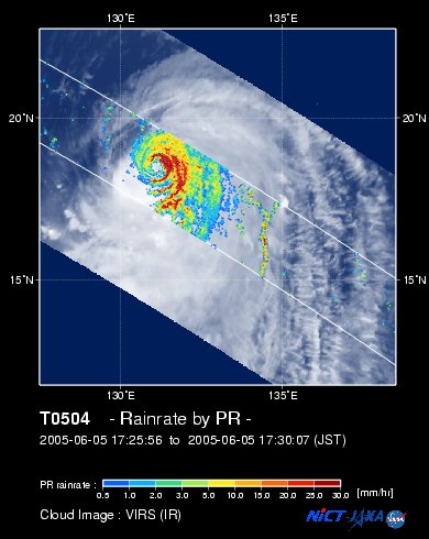
| Fig. 1 Rain rate distribution acquired by PR and cloud image acquired by VIRS. |
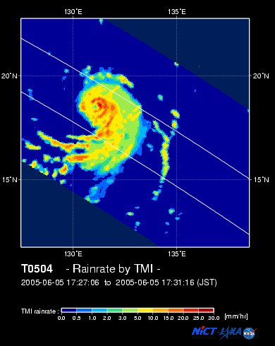
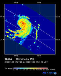
Fig. 2 Rainfall distribution acquired by TMI. |
Typhoon No. 4 (NESAT), the first typhoon that approached Japan this year, came close to the Kanto area on June 10 and 11, 2005. Last year, Japan experienced 10 typhoons which made landfall, the first in April. In June 2004, three typhoons approached Japan, and two made landfall. It's striking that Typhoon No. 4 of 2004 made landfall on Muroto Cape on June 11, and that it was the fifth typhoon of the earliest landfall season in Japan's history. Figure 1 depicts the near surface rain rate acquired by the Precipitation Radar (PR) and cloud image by the Visible Infrared Scanner (VIRS), both aboard the Tropical Rainfall Measuring Mission (TRMM) satellite, at 1728 (JST) June 5, 2005. Figure 2 displays surface rain rate acquired simultaneously by the TRMM Microwave imager (TMI). It has an atmospheric pressure of 940 hectopascals at the center, and a maximum wind speed of 45 meters per second at 1500 (JST) June 5.
The "eye," or center, of a typhoon, is unclear through cloud images. Observation by the PR, however, reveals that rainfall area develops along the eye-wall cloud, and rainfall on the eastern side is stronger than the other areas. Moreover, observation by microwave radiometer reveals the existence of the eye and heavy rainfall areas developed around the typhoon.
|
|
| Fig. 3 3-D Movie of rain rate distribution acquired by PR. |
Figure 3 is a 3-D movie of horizontal and vertical rain rate distribution observed by PR. Typhoon clouds are produced from cloud top radiance data acquired by VIRS. It is clear that tower-like precipitation structures near the eye-wall clouds develop at a higher altitude.
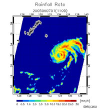 |
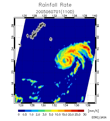
| Figure 4 Rainfall distribution acquired by AMSR-E aboard Aqua satellite. |
Figure 4 illustrates the rainfall distribution of Typhoon No. 4 observed by the Advanced Microwave Scanning Radiometer for EOS (AMSR-E) aboard NASA's Aqua satellite, at 0154 (JST) June 7, 2005. Compared to TRMM's observation of two days before, a well-developed rain area moved toward the northeast. Note that the eye of the typhoon has weakened but still exists.
On June 8, 2005, EORC established JAXA/EORC Tropical Cyclone Database, which merges the TRMM Tropical Cyclone Database and the AMSR/AMSR-E Tropical Cyclone Database. Previously, these two databases operated separately. The integration of these databases enables the new database to search tropical cyclones, including typhoons and hurricanes, observed by PR, TMI, VIRS, AMSR-E and AMSR aboard Midori-II, simultaneously. Three-dimensional movies of typhoons observed by TRMM/PR have recently been added (currently, observation period is limited but will be updated), and enable us to look at the 3D structure of precipitation in more detail.
Explanation of the images:
Figs. 1 and 3
Fig. 2
Fig. 4
|
|
|
|