Seen from Space 2005
Asian dust (KOSA) blows up from the Continent
| |
On November 7, Asian dust (KOSA, meaning "yellow sand" in Japanese) was observed in various districts of Western Japan. This yellow sand was blown up from the Asian Continent by a frontal wind with low atmospheric pressure and was brought to Western Japan by the prevailing westerlies there.
 |
| Fig. 1. Asian dust over Western Japan |
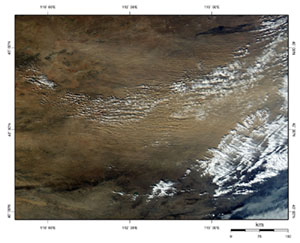
Figure 1, observed at 1250 (JST) on November 7, shows the distribution of clouds and dust extending over Western Japan and the Korean Peninsula.The white hatched portion is clouds; the brown hatched portion is thick dust in the air. There is a low- pressure vortex centered near Hokkaido. It's clouds stretch over from Western Japan to the Japan Sea. A thick dust area spreads along this cloud line. This thick dust is the Asian dust.
 |
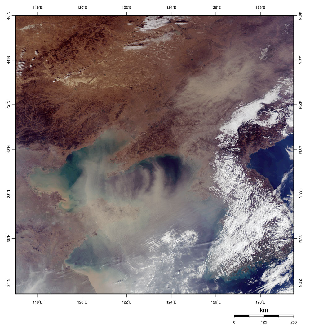
| Fig. 2. Dust blown up on the continent |
Let us explain this movement of dust step by step. Figure 2, observed at 1300 on November 5, depicts the northern part of China. A low- pressure front is passing southeast of Lake Baikal, and a sandstorm occurs around it.
 |
| Fig. 3. Asian dust approaches the Yellow Sea |
Figure 3, observed at 1345 on November 6, depicts the Yellow Sea. The blowing sand is carried by the prevailing westerly over the Yellow Sea.
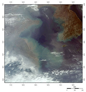 |
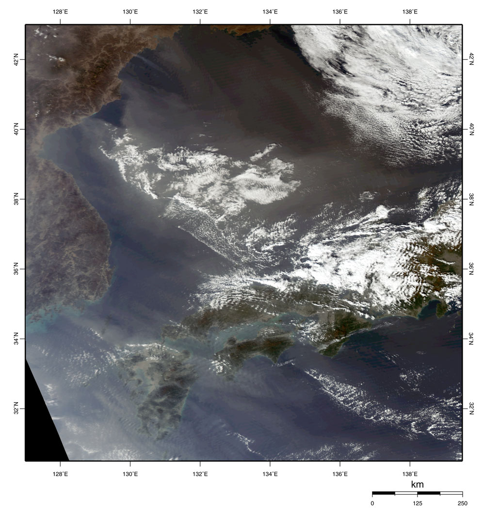
| Fig. 4. Asian dust reaches the Pacific Ocean |
Figure 4, observed on November 7, depicts the western boundary in Fig. 1. A strong northwest wind blows a low-pressure zone over the Yellow Sea and the Sea of Japan .The dust is blown up and carried by this strong wind. The green hatched area on the coast of the Yellow Sea is muddy sea- water.A lot of silt and sand flows into the Yellow Sea from the mouth of Yangtze-Jiang.
 |
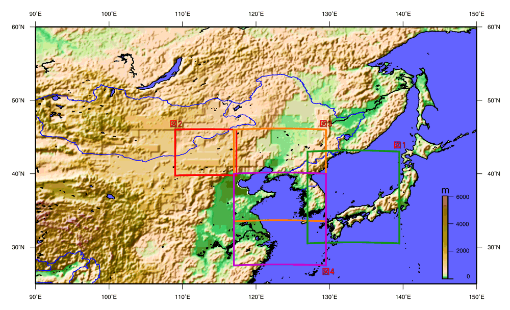
| Fig. 5. Allocation of shown figures |
Asian dust is observed in Japan with a strong seasonal northwest wind, mostly from the end of winter through to spring. The strong seasonal northwest wind also blows in autumn, but the Asian dust is seldom observed. This Asian dust was observed this autumn for the first time in three years (see the Asian dust (KOSA) on November 11 and 12, 2002). When Asian dust occurs, the visible range decreases, laundry in the open air becomes dirty with sand, and the crops are spoiled.
JAXA will continue using spacecraft observation to observe such seasonal events.
Explanation of the images:
Figs. 1 - 3
| Satellite: |
EOS-Aqua (NASA) |
| Sensor: |
Moderate Resolution Imaging Spectro-radiometer (MODIS; NASA) |
| Time and date: |
1250 (JST) on November 7, 2005
1440 (JST) on November 5, 2005
1345 (JST) on November 6, 2005
|
Fig. 4.
| Satellite: |
EOS-Terra (NASA) |
| Sensor: |
Moderate Resolution Imaging Spectro-radiometer (MODIS; NASA) |
| Time and date: |
1115 (JST) on November 7, 2005 |
Color composition was made by using three of 36 channels on MODIS; channel 1 (620 to 670 nm) for red, channel 4 (545 to 565 nm) for green, and channel 3 (459 to 479 nm) for blue. The image appears as though seen with the naked eye.
| Deep green: | Forests |
| Deep brown: | Steps, red leaves of autumn, naked rock |
| Ocher: | Deserts |
| White: | Clouds of water vapor |
| Gray: | Smoke |
| Gray-brown: | Asian dust |
| Gray-green: | muddy sea surface |
| Deep blue: | clear sea surface |
|
 |
|