| |
 |
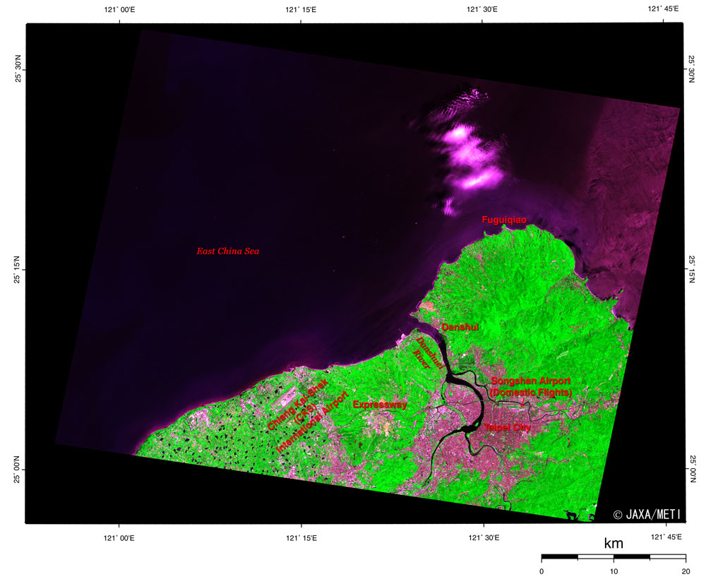
| Fig. 1 Taipei and Vicinity |
Figure 1 depicts Taipei, the central city in Taiwan, and its outskirts as observed from the Optical Sensor aboard the Japanese Earth Resources Satellite-1 in April 1998. The upper half is the East China Sea; Fuguiqiao, the northernmost tip in Taiwan, is on the upper right; and the Danshuei River flows from south to north. The grayish pink area on the eastern coast of the Danshuei River is an area in Taipei City, and the Songshan Airport for domestic flights can be seen on the northern side of the city. Chiang Kai-Shek (CKS) International Airport is on the left and is linked to Taipei by the expressway. Many reservoirs surround the airport, and the vivid green indicates the rich vegetation in land areas (except for the city).
 |
| Fig. 2 Expanded Image of City Area in Taipei |
In Fig. 2, the Danshuei River flows from south to north, the Keelung River, a branch, flows from east to west, and the Hsintien Stream, another branch, flows to the northwest. The area surrounded by these rivers is the city area of Taipei City. There is a governmental offices' district in the western part of the city, near the Danshuei River, and you can also see the Presidential Office Building, the CKS Memorial Park, the Taipei 2-28 Peace Park, and the Taipei Station. The CKS Memorial Hall in the CKS Memorial Park commemorates President Chiang Kai-Shek. The Taipei 2-28 Peace Park commemorates the 2-28 incident of 1947. Taipei Station can be seen in white, but the tracks cannot be seen because they are laid at the basement. The Taiwan High-Speed Rail, presently under construction, is expected to begin operating in October 2006 by introducing the Superexpress technology from Japan, and the rapid transit railway technology in Germany. It will link Taipei Station and Kaohsiung, the metropolis in southern Taiwan, a distance of 345 km, in only 80 minutes.
In addition, the eastern part of the city is developing, and you can see the National Dr. Sun Yat-sen Memorial Hall commemorating the Father of the Republic of China, Taipei City Government, Taipei World Trade Center, etc. Taipei 101, the world's highest building at present, was under construction at the time of Fig. 2. It is 508 m high and has 101 floors above ground; the opening ceremony took place December 31, 2004. The National Taiwan University is in the southern city area.
In Fig. 2, we can observe the expressway under construction, and the Taipei Zoo with a vast area of 165 hectares (Ueno Zoological Gardens is 14 hectares and Asahiyama Zoo in Asahikawa City is 15 hectares) in the lower right. Running east to west in the center of the figure is National Highway No. 1, the main artery in Taiwan, extending from Keelung City in the east to the Chiang Kai-Shek International Airport in the west, and then changing direction to the south, and finally reaching Kaohsiung city, for a total length of 372.8 km. The construction on National Highway No. 1 started in 1971; it was partially opened in 1974 and fully opened in 1978.
Xin Beitou Hot Spring, the National Palace Museum, the Grand Hotel, and the Martyr's Shrine are in the upper portion of Fig. 2. The Germans discovered Xin Beitou Hot Spring in 1894, the Japanese built a Japanese-style inn with a hot spring in the next year (1896) Japan's government started, and it led to the following development of the hot spring town.
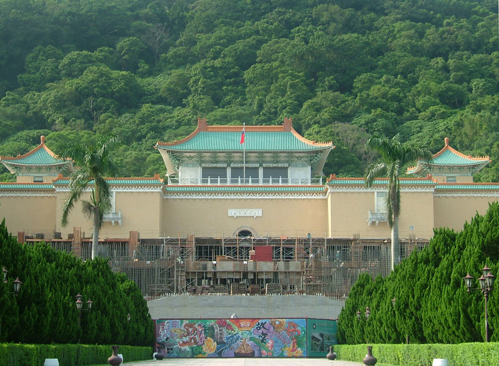
The National Palace Museum is one of the major museums in the world and equals the British Museum in London, the Louvre Museum in Paris, the Metropolitan Museum of Art in New York, and the State Hermitage Museum in St. Petersburg, and is proud of its nearly 700,000 collections that the successive emperors in China have accumulated. The National Palace Museum in Beijing possessed these collections originally, but they were moved to Nanjin in 1933 and then to three places in Szechwan Province in 1937 to protect them when the Japanese military invaded China. They were returned to Nanjin and Beijing after World War II, but the carefully selected collections were carried to Taipei in 1948 as the civil war between the Kuomintang and the Communist Party intensified, and they have remained there since. Incidentally, a large-scale remodeling is being conducted at the National Palace Museum from April 2004 to June 2006, and therefore the display space made public at the main building is currently restricted to 1/3 of the original area.
The Grand Hotel is a 14-story, first-class hotel with a Chinese palace building style.
At the Martyr's Shrine, approximately 330,000 spirits of the dead, such as the officers sacrificed in the anti-Japanese war and the civil war between the Communist Party and the Kuomintang, are deified.
 |
 |
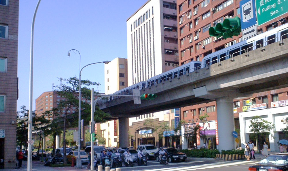
| Fig. 3 MRT |
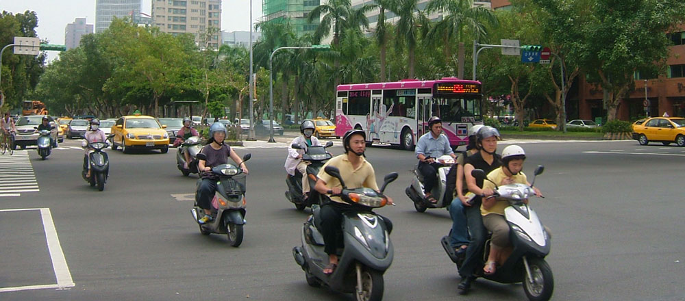
Fig. 4 The scooter fleet |
 |
 |
| Fig. 5 The National Palace Museum |
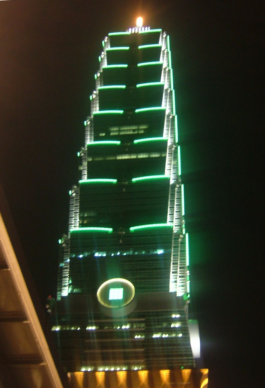
Fig. 6 Taipei 101 at night |
Figures 3 through 6 are photographs taken at the site in August 2005. The construction of the Mass Rapid Transit (MRT) is continued to eliminate traffic jams in the downtown area. Figure 3 presents the Muzha Line (an elevated structure), which was adopted as a people mover (automated guideway transit: AGT). It opened in 1996 and is operated unmanned. The other rail lines such as the Danshui Line and the Banqiao/Nangang Line adopt standard gauge track and become subways in the inner city. We are overwhelmed by the many scooters used in the inner city as observed in Figs. 3 and 4.
JAXA will launch the Advanced Land Observing Satellite (ALOS) in the near future. It will carry the Advanced Visible and Near Infrared Radiometer 2 (AVNIR-2), which is capable of 10 m ground resolution. We will distribute clearer images at that time.
Explanation of the images:
Figs. 1 and 2
Figures 1 and 2 were produced by assigning red to the visible channel (0.63 to 0.69 µm), green to the near-infrared channel (0.76 to 0.86 µm), and blue to the visible channel (0.52 to 0.60 µm). The resulting figures have natural coloring, with vegetation slightly emphasized, yet still appearing as though observed with the naked eye. In these images, city areas are grayish pink, forests are dark green, grassland and farmland are light green, and water surfaces and areas with no data are black.
|
 |
Related Sites:
 Northern Pakistan Northern Pakistan
The City on the Mississippi Delta: New Orleans, Louisiana
Berlin: The city divided by a wall (part 2)
Berlin: The city divided by a wall (part 1)
World Heritage Site Surrounded by High-rise, Multifamily Housing: St. Petersburg
Einstein's "Miraculous Year": Bern, Switzerland
Bangkok: The Developing Capital of Angels
London: The Capital without fog
Appendices:
Beautiful Island (Ilha Formosa):
In the Age of Discovery from the 15th century to the 16th century, when a sailor of a Portuguese ship saw the beautiful silhouette of the island of Taiwan for the first time, he shouted "Ilha Formosa." It is estimated that in the next year (1544) the Portuguese ship drifted ashore to Tanegashima Island in Japan and guns were introduced. In Portuguese, Ilha means the island and Formosa means beautiful; therefore, Formosa becomes a code name in Taiwan. The artificial satellites developed by the National Space Organization in Taiwan were named "Formosat."
Chi-Chi earthquake:
A 7.6 magnitude earthquake occurred in the early dawn on September 21, 1999, with the epicenter in central Taiwan. It was the biggest earthquake in Taiwan in the 20th century.
Please refer to "Tectonic interpretation of the Taiwan earthquake on Sept. 21, 1999" on the home page of Earthquake Research Institute, University of Tokyo.
Name of the era:
In Taiwan, the name of the era, "the Republic of China" (R.O.C.), is used in addition to the Christian era. This name indicates how many years have elapsed since the Chinese Revolution in 1911. The year 2005 corresponds to R.O.C. 94.
|
|