ページの先頭です。
本文へジャンプする。
【Important Notices】This page is an archive page of information published in the past. Since the update has been completed, it may contain broken links or outdated information. For the latest information, please use the new site Earth-graphy (earth.jaxa.jp).
ここからサイト内共通メニューです。
サイト内共通メニューを読み飛ばす。
サイト内共通メニューここまで。
ここから本文です。

Seen from Space 2005

Dhaulagiri, Himalayas: Eight-Thousand Meter Peak and Glaciers (Part 3)

 
The figure depicts Dhaulagiri I, with a peak of 8,167m above sea level, and other mountains in the Himalayas, as observed by the optical sensor aboard Japanese Earth Resources Satellite-1 (JERS-1). Nilgiri, with a peak of 7,061m, is part of the Annapurna Himal (mountain group) on the right. The Dhaulagiri Himal is in the lower center. White or pale purple indicates the mountainous areas covered with snow or ice. This image was acquired before noon, local time, as the sun shone from the lower right, causing the steep mountaintops and ridges to cast their own dark shadows on the upper left flanks of the mountains.

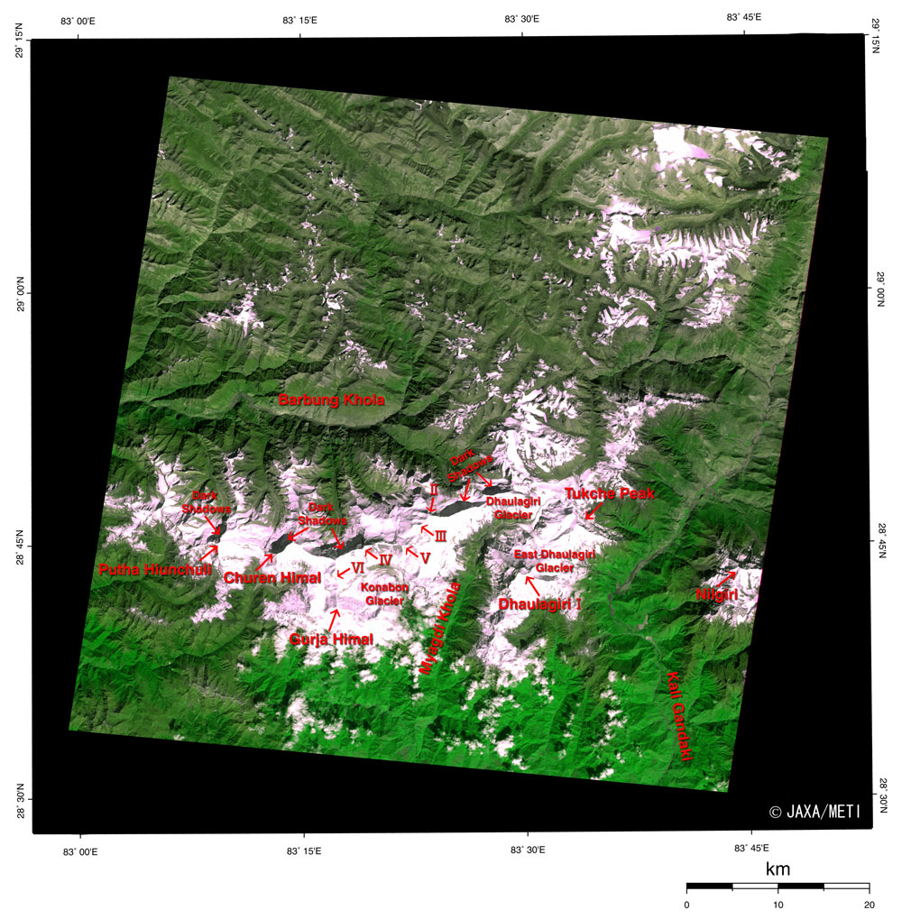
The figure covers the area within Nepalese territory. The border with China is just above the figure. The area near the upper end of the figure appears as brownish olive green and light purple, representing the arid region of sparse vegetation that extends into Tibet. The area near the bottom of the figure appears as vivid green, indicating rich forest.

Surrounding Dhaulagiri I, in the lower center of the figure, are Tukuche Peak (6,920m) on the northeast, Dhaulagiri II (7,751m), Dhaulagiri III (7,715m), Dhaulagiri V (7,618m), Dhaulagiri IV (7,661m), Dhaulagiri VI (7,268m), Gurja Himal (7,193m), Churen Himal (7,371m), and Putha Hiunchuli (7,246m).

There are some glaciers in the higher altitude valleys in the Dhaulagiri Himal. On theupper right, the glaciers stand in line like the backbone of a whale and the small glacial lakes shown in purple accompany two wide glaciers. The area of the upper glacier is approximately 13sq km, and the lower one is approximately 8sq km (refer to the scale bar).

In the reference, we find that "Dhaulagiri" originates in "Dhavalagiri" from the Sanskrit: "dhavala" means "white" and "giri" means "mountain."

The growth and melting of glaciers are indices for measuring global warming. Some report that glaciers are easily affected by global warming in places at relatively low latitudes as well as at high altitudes, as in the Himalayas and Tibet. As glaciers retreat and contract, glacial lakes collapse, flooding downstream areas and causing sea levels to rise. Continued careful observation is therefore essential.


Reference:
Himalaya Meihou Jiten (in Japanese), Heibonsha Ltd., 1996

Explanation of the image:
Satellite: Japanese Earth Resources Satellite-1 (JERS-1)
Sensor: Visible and Near Infrared Radiometer (VNIR)
Date: 0518 (UT) on October 22, 1993
Ground resolution: 18.3m x 24.2m
Map Projection: Universal Transversal Mercator
We produced the figure by assigning red to the visible channel (0.63 to 0.69µm), green to the near-infrared channel (0.76 to 0.86µm), and blue to the visible channel (0.52 to 0.60µm). The resulting figure has natural coloring, with vegetation slightly emphasized and snow and ice looking purplish, yet still appearing as though seen with the naked eye. In this image, snow and ice are white or pale purple, forests are dark green, grasslands are olive green, glacial lakes are deep purple, and water surfaces and areas with no data are black.

Related sites:
Cho Oyu, Himalayas: Eight-Thousand Meter Peak and Glaciers
Eight-Thousand-Meter Peak and Glaciers: Shishapangma, Himalayas
Land, Seen from Space

本文ここまで。
image:Satellite Navigator
image:Satellite Applications and Operations Center(SAOC)
Earth Data Collection by JAXA Satellites
image:ページTOP