Seen from Space 2005
Berlin: The city divided by a wall (part 1)
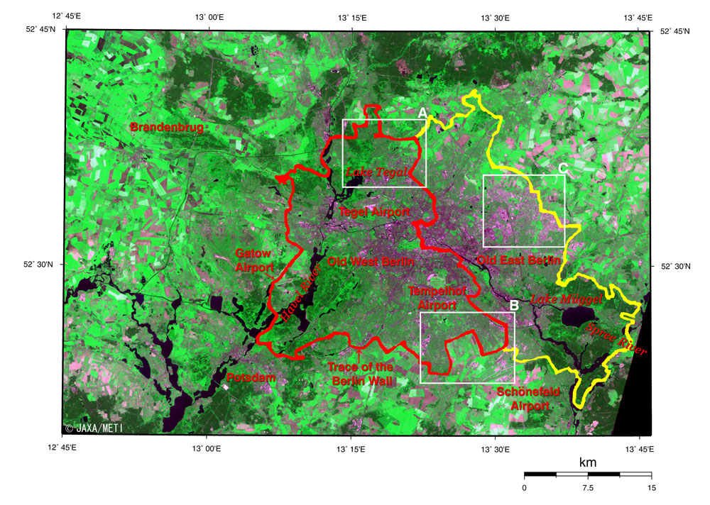
Figure depicts Berlin, Germany's capital, and its outskirts as seen from the Optical Sensor aboard the Japanese Earth Resources Satellite-1 in May 1993. Berlin is surrounded by the state of Brandenburg, which has Potsdam as its capital, lower left. The Havel River flows from the lower left to the upper center through Potsdam. The Spree River flows from the lower right, through central Berlin from east to west and joins the Havel River. The dense green shows forests, and the lighter green and brown colors indicate farmland and grassland, which spread to the suburbs. The yellow line in the figure represents the city boundary of Berlin, and traces of the Berlin Wall are indicated by the red line. In central Berlin is the vast park, Tiergarten, (vivid green) which is 3 km wide from east to west and 1 km from north to south. There are three airports in old West Berlin. This is because three countries, the USA, the UK and France, once occupied old West Berlin following World War II; the former East Germany was an occupied area under the former USSR; and old West Berlin was surrounded by the former East Germany. The Schönefeld airport, an old East Berlin airport, is being extended and will be renamed the Berlin Brandenburg international airport in 2007. There are plans to close Tempelhof and Tegel airports when the Brandenburg airport opens. Frame A includes a trace of the old Berlin Wall in Reinickendorf ward in old West Berlin. Almost all of the Berlin Wall, which used to be over 3 m in height, has already been removed. However, there used to be a No-Man's-Land tens of meters wide between the double fences of the wall, and this can be clearly seen in the satellite image. Frame B includes a trace of the Berlin Wall in Neukölln ward in old West Berlin. On the side of old West Berlin is a residential area, and the side of old East Berlin is farmland and pasture, indicating the clear difference in land use. The full length of the Berlin Wall that surrounded old West Berlin reached 155 km, with 46 km of that being the boundary with old East Berlin. During the cold war, it isolated old West Berlin for over 28 years, from 1961 to 1989, and it divided Berlin from east to west. You can also find some multifamily housing in frames A and B, including 31 story (90 m high) buildings constructed in the 1960's. The residents disliked these because there were few public spaces and amusement establishments. Frame C includes some more large-scale multifamily housing composed of 10 to 20 story buildings in Maltzan ward in old East Germany. This residential housing constructed from the 1970s to the 1980s was disliked by its residents for the very same reasons. Reference: Kido Eiichi, "Berlin the past, present and future" (in Japanese), San-ichi Shobou, 1998
Related Sites: Appendices: The Berlin blockade and the three airports: After the end of World War II in 1945, Germany and Berlin were divided and governed by the Allied Forces of the USA, the UK, France and the USSR. These three countries and the USSR gradually came to bad terms with the progression of the cold war. The occupied area by the USA, the UK, France out of Berlin (West Berlin) was surrounded by the occupied area by the USSR (East Germany), then each of the three countries had its own airport. The Tegel Airport constructed in only 49 days by the Corps of Engineers in the north was in the occupied area of France. The Gatow Airport in the west was in the British occupied area, and the Tempelhof airport in the south was in the occupied area of the USA. These airports made a spectacular showing in the airborne transportation of goods from the western side during the Berlin Blockade from June 24, 1948 to May 11, 1949. This airborne transportation continued until September 30, 1949. Berlin Wall: East Germany suddenly began the construction of a wall at midnight on August 13, 1961 using barbed wire, and was finished by 1 p.m. that same day. During the cold war, that began as World War II ended in 1945, West Berlin became the western enclave remaining in East Germany. Therefore, West Berlin became the destination of the refugees who escaped from the communist administration in the east. However, to avoid the outflow of the experienced young workforce that the communist country needed, East Germany set about the construction of a larger wall. In the month of June 1962, the construction of a parallel wall began on the East German side, several meters to tens of meters from the first wall. The area between the two fences was called "no-man's-land" and watchtowers and checkpoints on the roads were established. In 1975, it became a 3.6 m high reinforced concrete wall. There were 14 checkpoints along the Berlin Wall, including railroad stations. There were some checkpoints exclusively for West Berlin citizens, diplomats and foreigners, and the entrance and exit of the autobahn that directly connects West Germany and West Berlin through East German territory. At 7 p.m. on November 9, 1989 inspections at the checkpoints ceased, and the wall lost its meaning; its destruction began shortly thereafter. Most of the wall was removed by East Germany except for three blocks, including a part near Potsdamer Platz 80 m in length. |
|||||||||||||||||||