Seen from Space 2005
Cho Oyu, Himalayas: Eight-thousand meter peak and Glaciers
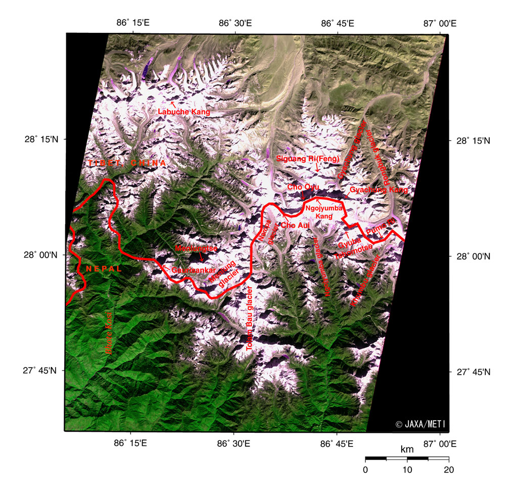
Figure, observed by the optical sensor aboard JERS-1, depicts Cho Oyu (8,201 m above sea level), with a peak of eight-thousand meters , and other mountains in the Himalayas. On the right, you can see the western half of the Khumbu Himal (mountain group), the Rolwaling Himal near the bottom, and the mountains centering on Labuche Kang (7,367 m above sea level) on the upper left. White or pale purple indicates the mountainous areas covered with snow or ice. This image was acquired before noon local time as the sun shone from the lower right causing the steep mountains to cast their own shadows on the tops and ridges. Nepal is in the lower portion of the figure, with Tibet,China in the upper portion, and the complicated border lying in an east-west direction. The upper portion of the figure looks brownish olive green and pale purple, indicating an arid region with sparse vegetation. The bottom portion of the figure is a vivid green, indicating rich forest areas. There is a dramatic change between the southern side and the northern side with the central mountainous region making a border. Cho Oyu, center right of the figure, is followed by the seven-thousand meter peaks of Gyachung Kang (7,952 m above sea level), Ngojumba Kang (7,743 m above sea level), Siguang Ri (Feng) (7,308 m above sea level), Cho Aui (7,354 m above sea level), Gyuba Tshomotse (7,036 m above sea level), and Pumo Ri (7,161 m above sea level). There are two seven-thousand meter peaks, Menlungtse (7,175 m above sea level) and Gaurisankar (7,134 m above sea level) in the Rolwaling Himal. The valleys located higher than 5,000 m above sea level are covered by glaciers. The Rongbuk glacier and the Gyachung glacier on the right of the figure are flowing on the Tibetan side. The Khumbu glacier, the Ngojumba glacier, the Nampa glacier and others are flowing on the Nepalese side. A British expedition party investigating a mountaineering route on Everest in November, 1951 found what appeared to be a footprint of a 'yeti' on the Menlung glacier at the bottom of the figure. The growth and melting of glaciers are considered indices of global warming. Some reports say that glaciers are easily affected by global warming in places at relatively low latitudes and high altitudes, as in the Himalayas and Tibet. As glaciers retreat and contract, glacial lakes collapse, flooding downstream areas and causing a rise in the sea level. For this reason, we have to continue careful observation. Reference: Himalaya Meihou Jiten (in Japanese), Heibonsha Ltd., 1996
Related Sites: |
|||||||||||||||||||