Seen from Space 2005
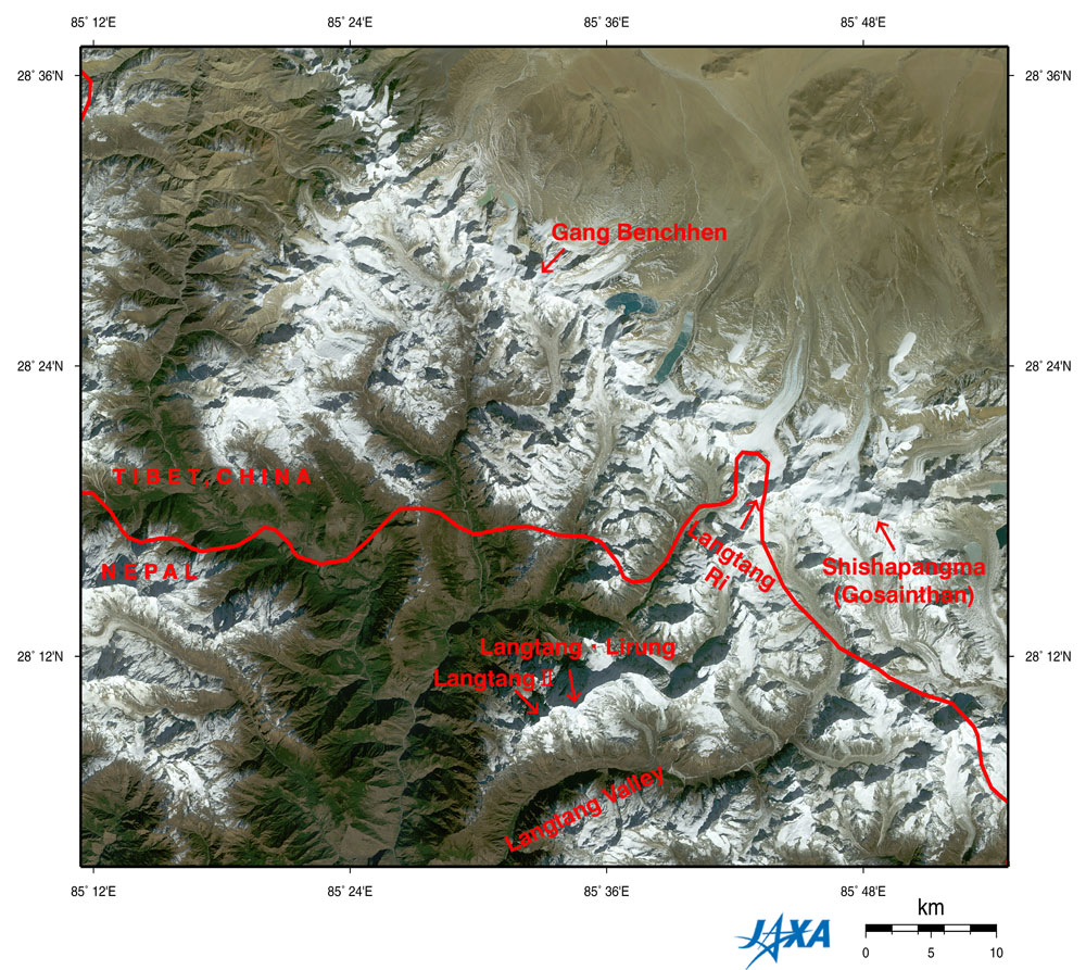
Eight-thousand-meter peak and Glaciers: Shishapangma, Himalayas
Figure depicts the Shishapangma (also known as Gosainthan) and Langtang Mountains in the Himalayas observed by AVNIR. The white sections are mountainous areas covered with snow. The steep mountains seem to cast their own shadows on the tops and the ridges, upper left. This is because the observation time was before noon local time as the sun shone from the lower right. Nepal is in the lower portion of the figure, and Tibet, China, is in the upper portion, with the complicated border lying in an east-west direction. Shishapangma is on the right of the figure, 8,012 m above sea level on the Tibetan side. You can see other seven-thousand-meter peaks, including Langtang Ri (7,239 m above sea level), Gang Benchhen (7,211 m above sea level), and Langtang Lirung (7,245 m above e sea level). Some glaciers can be seen in the center of the figure near the bottom of Langtang Valley on the Nepal side. Many glaciers line up in the northwestern area around Shishapangma on the Tibetan side. Some glaciers on the Tibetan side have glacial lakes downstream that look copper green or pale emerald green. The growth and melting of glaciers are considered indices of global warming, and some reports say that glaciers are easily affected by global warming in places at relatively low latitudes and high altitudes, as in the Himalayas and Tibet. As glaciers retreat and contract, glacial lakes collapse, flooding downstream areas and causing a rise in sea level. For this reason, we have to continue careful observation. Valley bottoms less than 1,500 m above sea level (lower left) appear veiled. This could indicate air pollution in the Katmandu basin. The mountainous area and Tibetan Plateau (higher than 3,000 m above sea level) look clear because the thin atmosphere has little influence on visibility.
Related Site: Appendices: Formation of the Himalayas: The Himalayas and Tibetan Plateau were formed some 40 million years ago when the Earth's crust that was at the bottom of the Tethys Sea and the Indian Plate subducted under the Eurasian Plate. The India Plate lifted the Indian subcontinent, continued north and collided with the Eurasian Plate. As a result, you can see large-scale folded structures and fossils of sea creatures such as trilobites, crinoids and ammonites, and you can mine rock salt. The Tethys Sea was closed for about 2,500 years preceding this. The Black Sea, the Caspian Sea and the Aral Sea are traces of the original Tethys Sea. The Indian plate today continues north at a speed of approximately 1 cm a year, and the Himalayas continue upheaving at a speed of 2 mm a year, causing many earthquakes in the Himalayas and the Tibetan Plateau. Influences on climate: The Himalayas influence climates in Southeast Asia and East Asia as well as climates in the Indian subcontinent and the Tibetan Plateau. Because they block the cool dry north wind, it becomes very hot in Southern Asia compared to other continents. In addition, because the Himalayas also block the wet seasonal wind from the south, it brings much rain to northern India and Nepal. Dry zones such as the Taklamakan and Gobi deserts are created on the other side of the Himalayas. In addition, the Himalayas are located approximately 28 to 35° North, where they significantly influence the flow of the westerlies, the prevailing winds blowing regularly and intensively from west to east in middle latitudes. For the paths of the westerlies change by seasons, they hit the western Himalayas in winter, bringing snow to Kashmir on the southern side and rain to Punjab further south (please refer to "Disastrous storms in Pakistan"). Furthermore, the westerlies pass along the southern side of the Himalayas during winter and along the northern side during summer. The westerlies tend to change their paths northwards gradually from spring to summer, but the Himalayas prevent temporally the path change and the precipitation tends to develop for a long term at the same place. In Japan, it corresponds with the rainy season. |
||||||||||||||||||||||||