Seen from Space 2005
Einstein's "Miraculous Year": Bern, Switzerland
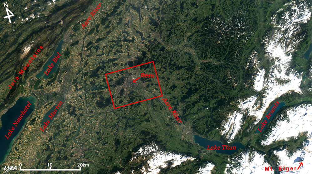
Figure 1 depicts northwestern Switzerland observed by AVNIR. It shows the Jura Mountains on the upper left. In the center is the flattest area in Switzerland, the Mittelland Plateau, and shadow shows on the northern face of Mt. Eiger (3,970 m above sea level), one of the most famous mountains in the Alps, in the bottom right. The source of the Aare River is located east of Switzerland. It flows through Bern via Lake Brientz and Lake Thun, changes direction once for the west, and then heads north and joins the Rhine at the border with Germany. Lake Biel and Lake Neuchatel are seen on the southern side of the Jura Mountains.
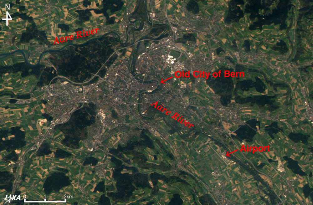
Figure 2 is an enlarged partial picture of Fig. 1, including the Swiss capital, Bern. Green and brown meadows and farmlands and dark green forests surround the grayish city area, 2.5 km wide in the north-south direction and 4.5 km wide in the east-west direction. The gray stripes are highways and bridges. The bold blue-green stripe is the Aare River. Bern Airport can be seen in the lower right. The town area of Bern is on the bend of the Aare River. To the east, is the Old City of Bern, one of UNESCO's world cultural heritage sites, where a city area was built on a hill surrounded by the Aare River in the twelfth century. The arcade that was built in the 15th century and the fountains of the 16th century have been preserved. In 1905, Albert Einstein worked in the Swiss Patent Office located in the old city of Bern. He published five epoch-making papers on Brownian motion, quantum theory, and the special theory of relativity that became the basis for physics in the 20th century. The year later became known as Einstein's "Miraculous Year." The United Nations General Assembly declared this year (2005) as "The World Year of Physics" to coincide with the 100th anniversary of Einstein's miraculous year, and various events are planned in many locations throughout the world to raise public awareness of physics and physical sciences. The apartment, where Einstein lived in the old city is now open to the public as "Einstein House."
Related Sites: Appendix: Jura Mountains and the Alps: A stratum of limestone is exposed over a wide area in the Jura Mountains. The limestone was formed during the Jurassic period (210 million years ago to 140 million years ago). The name Jurassic is associated with the Jura Mountains. The Jura Mountains are not as high as Mont Blanc (4,810 m above sea level) or the Matterhorn (4,478 m above sea level) in the Alps, and the highest peak, Crêt De La Neige, is only 1,718 m above sea level. The small factories supporting the Swiss clock industry lie scattered around the Jura Mountains. The Alps were formed when the African Plate collided with the Eurasian Plate at the time of the crustal movement (a part of the Alps orogenic movement) during the first half of the Tertiary period 35 million years to 25 million years ago. The Jura Mountains were also formed at that time. The many U shaped valleys and lakes were formed later by ice during the ice age that continued from 1,700,000 years ago to 10,000 years ago. |
|||||||||||||||||||||||||||||