Seen from Space 2005
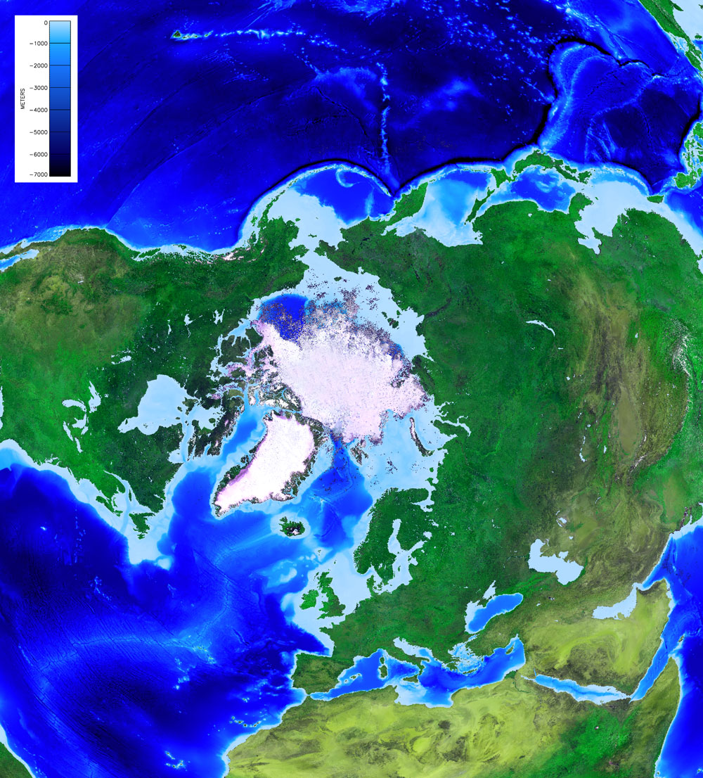
Relief of the Arctic: Earth, floating ice, and seafloor by MODIS
This image captured in late summer 2003 by MODIS shows the continents and floating sea-ice cover around the North Pole. You can see the Japanese islands (upper right), Caspian Sea and Black Sea (lower right), Greenland (lower left), and North America (upper left). Sea depth is shown by deep blue for open water areas (NGDC/NOAA ETOPO2 global bathymetry data is used). Spreading over the Eurasian Continent and the North American Continent is a vast green area, which contrasts well with non-vegetation areas of the Sahara Desert, the Middle-East, and the Tibetan Plateau. During this season, the area of the Arctic sea ice is at its annual minimum. The seasonal variation of the Arctic sea ice from spring to autumn of the same year was previously reported on this web page ("Accelerated Sea-Ice Melting in the Arctic"). Also from the image above, large open water areas are seen to the north of Alaska and Siberia. During this season, the Arctic sea ice tends to shrink year by year, possibly due to global warming. "The continued decline in Arctic ice cover has led to speculation that the Arctic Ocean may become completely ice-free during the summer season some time within this current century (NSIDC News) Careful monitoring should be continued. The seafloor, usually hidden under the deep ocean, is depicted in the image. The area in the central Atlantic Ocean that is shallower than the surrounding floor, is "the Mid-Atlantic Ridge," which is several thousand meters higher than the surrounding floor and extends nearly to the entire Atlantic Ocean north to south connected to Iceland. This is an example of a divergent-plate boundary where new ocean crusts (ocean plates) are created and heat flows out from the interior of the Earth (the mantle). This is the cause of the many active volcanoes in Iceland. There are several ocean depths exceeding eight thousand meters to the east of Japan, such as the Japan Trench and Izu-Ogasawara Trench where three plates converge, and the Pacific Plate is subducted under the North American Plate and the Philippine Plate. In ocean topography, there is much more variety than in land topography. Finally, there are many shallow areas less than several hundred meters in depth in the Arctic Ocean. These shallow areas have less heat capacity compared with the Pacific and Atlantic Oceans. It is easy to speculate whether the Arctic sea-ice is susceptible to global warming.
Related sites: |
|||||||||||||||||||