Seen from Space 2005
Winter Scenery in East Hokkaido: Drift ice and a lattice-shaped windbreak forest “Great Green Grid”
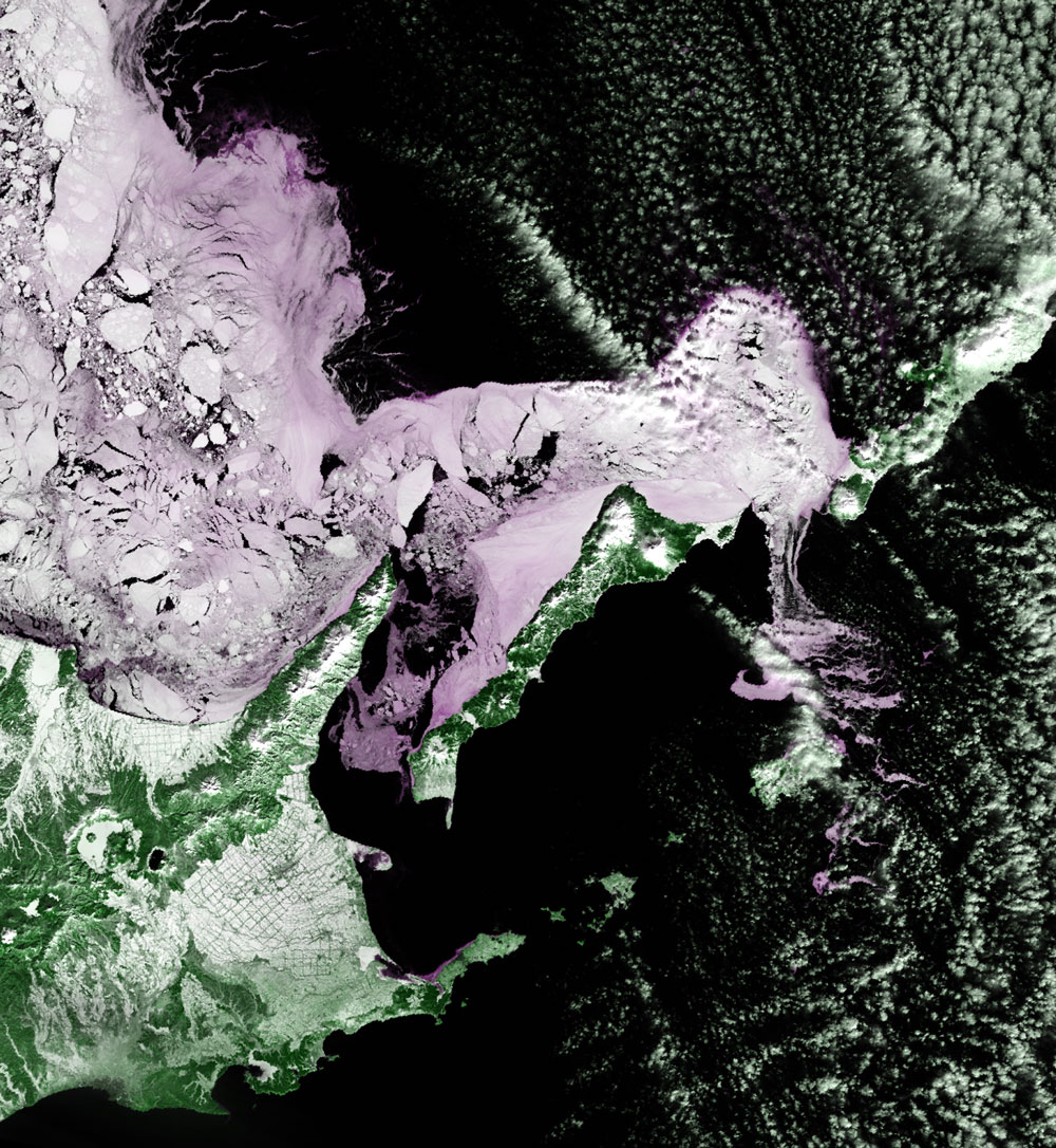
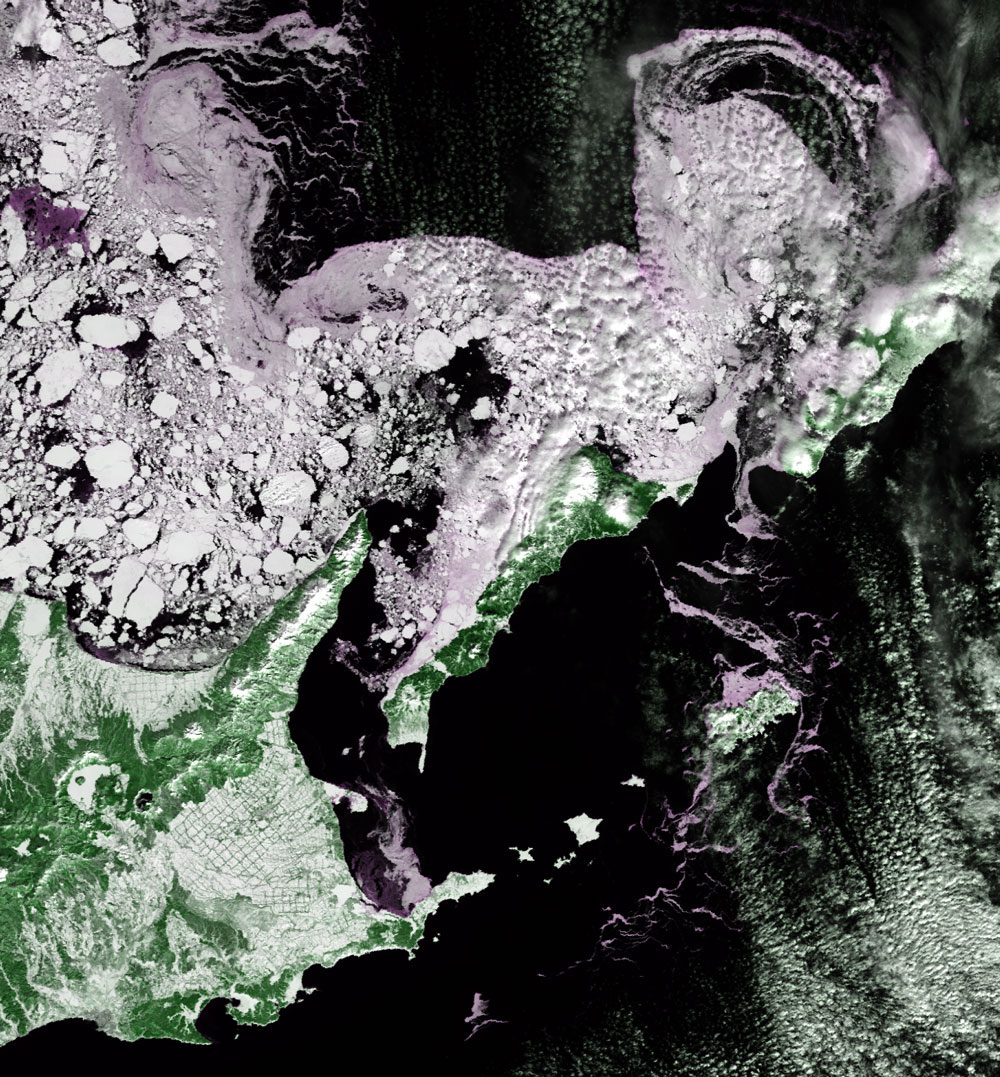
Figure 1 indicates that drift ice reaches the coasts of the Sea of Okhotsk between Lake Notoro and Cape Shiretoko. Drift ice also reaches the north shore of the Kunashir Island and begins to flow into the Pacific side from Kunashir Island and Iturup Island (Kunashir Channel). Figure 2, acquired 11 days after Fig. 1, shows that drift ice was separated from the Sea of Okhotsk side of Hokkaido and moved to the east with the distribution of drift ice becoming sparse. Some drift ice flowing to the Pacific side reaches the south of Nemuro Peninsula, where it is necessary for ships passing in the area to be alert for the drift ice. The Japan Meteorological Agency stated in its news release that "the sea ice area over the Sea of Okhotsk last month (February, 2005) was smaller than that of the average year through the month.” It also stated that "a sea ice area was the same as that of the average year in the southern part (southward of lat. 50 degrees N) of the Sea of Okhotsk as of the end of February, and a large scale outflow was observed from Kunashir Channel into the Pacific." Please refer to the news release "the sea ice of the Sea of Okhotskin this winter (the third report)(Japanaese only) ."
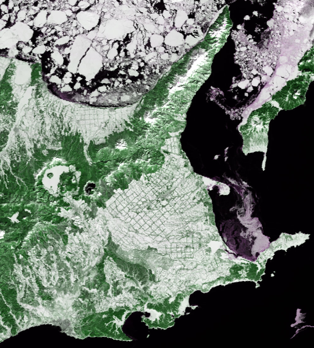
The checked pattern at the center of Fig. 3 in Konsen Plateau is called a lattice-shaped windbreak forest. It became famous after astronaut Mamoru Mori captured it with a video camera when he flew aboard the space shuttle "Endeavour" in February 2000.In November 2001 it was chosen to be a part of Hokkaido Heritage as "a lattice-shaped windbreak forest in Konsen Plateau". You can also see a lattice-shaped windbreak forest on the north side of Mt. Shari. It is effective in alleviating the strong blowing wind, thus preventing damage to crops. It keeps the ground at a more constant temperature and helps to prevent scattering of surface soil and manure. It has now been evaluated as a home and passage of wildlife, and a source of carbon dioxide absorption as well as windbreak . In January 2004, Japan's government decided to recommend "Shiretoko" to be placed on the World Heritage List, and submitted a recommendation to UNESCO World Heritage Center. Document examination and local investigation by the consultative body of the World Heritage Committee (International Union for Conservation of Nature and Natural Resources: IUCN) must first be done. If this goes smoothly, placement of Shiretoko on the World Heritage List of outstanding natural sites will be decided during the 29th session of the World Heritage Committee in July 2005. According to the news release of the Ministry of the Environment , the major characteristics of Shiretoko are as follows: ・An interactive ecosystem that consists of bountiful sea and forests that are linked by rivers, ・Outstanding natural beauty with its landscape and seascape changing dramatically with the four seasons such as the sea ice scenery during winter and the beautiful colors of the autumn forest, and ・A unique combination and distribution of species due to its geographical location and diverse natural environment, where southern and northern species co-exist.
Related sites: Appendices: Geographers and explorers who walked Hokkaido in the Edo era: Tadataka Ino (1745-1818) surveyed all of Japan during his ten surveying trips, from north to south Hokkaido to the south of Yakushima Islandbetween 1800 and 1816 (about 200 years ago). He was the first to make a map of the Japanese Islands from actual surveys . In his first survey in 1800, he entered the Ezo (Hokkaido) via the Oshu Road and surveyed the Pacific coast of Hokkaido covering the west of Hakodate to Konsen Plateau in east Hokkaido. At that time, he met Rinzou Mamiya (1780-1844) near Hakodate, and they concluded their master and pupil relation. Rinzou discovered Mamiya Channel in his second Sakhalin exploration in 1809 and also surveyed the all the land of Ezo including the remaining shore region (the Sea of Japan side and the Sea of Okhotsk side) and inland region. He played a major role in completing the Hokkaido part of Dai-Nippon-Enkai-Yochi-Zen-Zu (Japan shore total land chart) by Tadataka Ino. Half a century later, Takeshiro Matsuura (1818-1888) explored Ezo a known six times from 1845 to 1858, leaving voluminous documents including Touzai-Ezo-Yamakawa-Chiri-Torishirabe-Zu (East and west Ezo mountains and rivers geography investigation chart) through a relationship and cooperation with the Ainu people (an aborigine in Hokkaido). After the Meiji Restoration in 1868, he became an Ezo reclamation third-ranking official and then Ezo reclamation commissioner. He named many places in Hokkaido, and became a godparent of Hokkaido. "Shiretoko" is based on "Shiri Itoko" (meaning the place where the land ends) in Ainu, and its Chinesecharacter was chosen by Takeshiro. Reference materials: Nara Women's University image original database "Shiretoko Nisshi (diary)" (Japanese only) An opening of a lattice-shaped windbreak forest : Horace Capron (1808-1885), an adviser for the Hokkaido Bureau of Development, proposed installing forest belts of 100 ken (180 m) width in 1890. Based on this, the Hokkaido Assembly decided to leave the land to be used for windbreak forests every 1,800 ken (3,240 m) in 1896. In East Hokkaido, the creation of windbreak forests entered full swing from the end of Taisho era to early Showa era (1926), about 80 years ago. Now the area of the lattice-shaped windbreak forest in Konsen Plateau extends to the four towns of Shibetsu, Shibecha, Bekkai and Nakashibetsu, in the center, and covers 15,700 ha. Reference materials: A lattice-shaped windbreak forest - "GREAT GREEN GRID," (Japanese only) Nakashibetsu town |
|||||||||||||||||||||||||