Seen from Space 2005
Bangkok: The Developing Capital of Angels
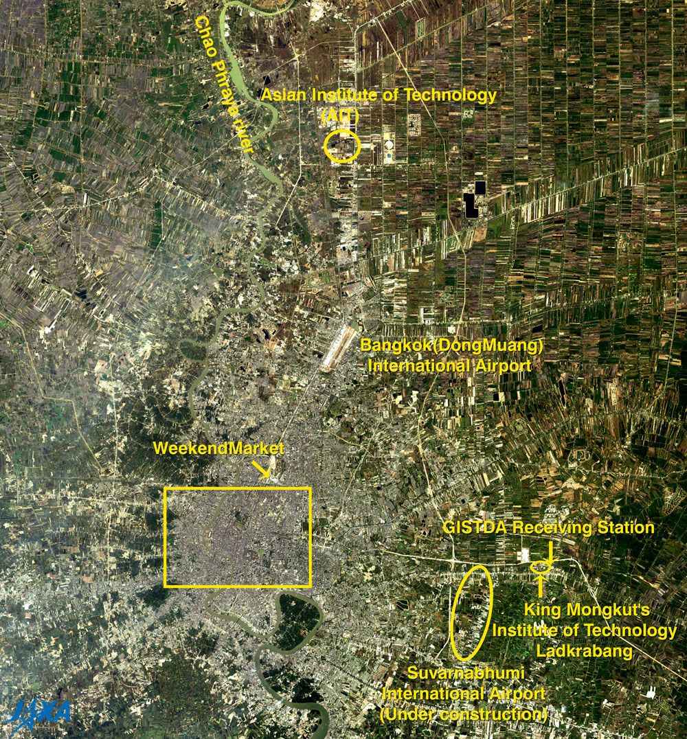
The Advanced Visible and Near-Infrared Radiometer (AVNIR) aboard JAXA's (former NASDA) Advanced Earth Observing Satellite "Midori" (ADEOS) captured images of Bangkok, the capital of the Kingdom of Thailand, and its surrounding area eight years ago (in 1997). The figure depicts the Bangkok International Airport at Don Meuang (whitish and clear in the center), the city area of Bangkok (brownish gray in the south of the airport). The River Chao Phraya runs from north to south in Bangkok, appearing greenish gray, indicating that it is somewhat muddy. Prawn farms south of the Bangkok city area appear light green at the edge of the figure. Other major areas are green or brown indicating widespread rice fields and farmlands. The roads, especially expressways, appear as white stripes.
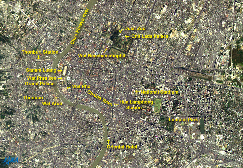
Figure 2 is an expanded image of the Bangkok city area. You can see boats coming and going on the River Chao Phraya. Bangkok was previously called "Venice of the East" because of its prosperous canals, but many canals were filled and transformed into roads with the progress of economic development. However, you can still find some canals if you look at the figure well. A capital was set in the Thonbury district on the west side of the River Chao Phraya from 1767 to 1782, but the present Bangkok dynasty was founded in 1782 and the Grand Palace and Wat Phra Kaeo (Emerald Buddha Temple) were built as the center of the dynasty. There are many Buddhist temples (wats) in the Bangkok city area. Near the Palace, there is Wat Pho (Nirvana Temple) where the huge statue of The Buddha lies on its side, and Wat Arun that was the scene of the three part "Akatsuki no Tera (Dawn Temple)" of "Hojo no Umi (Sea of Fertility)", which was the posthumous quaternary work of Yukio Mishima (1925-1970). Wat Benchamabophit (Marble Temple), made from marble imported from Italy, is located to the northeast of the Palace. Near the temple stands the Dusit Zoo and Chitlada Palace where his Majesty King Bhumibol Adulyadej and his Majesty's family live. Chinatown lies to the southeast of the Palace, and farther on, is the Hua Lumphong station, the largest railway station in Thailand, which connects to every major destination in Thailand. South of the station, facing the River Chao Phraya, is the Oriental, a hotel known for providing the world's best service. The hotel opened in 1876, and is famous for the great writer William Somerset Maugham (1874-1965) staying there and writing. You can see many tall buildings attached by dark shadows on their upper left, on the east of the Oriental and on the east of Lumpini Park. Figure 1 presents some facilities that are closely related to JAXA. One is the Asian Institute of Technology (AIT) in Klong Luan (upper), and others are the ground station of the Geo-Informatics and Space Technology Development Agency (GISTDA) and King Mongkut's Institute of Technology Ladkrabang in Ladkrabang (right). Presently in Bangkok, expressways provide relief from traffic jams in addition to the elevated Bangkok Mass Transit System (BTS), commonly called "Skytrain," which began operation in December 1999. The subway has also been completed and began operation in July 2004. Additionally, the Suvanabhumi International Airport is under construction as the second international airport and should be completed by the end of September 2005. We are looking forward to acquiring and providing the latest images of Bangkok by Advanced Land Observing Satellite (ALOS) after its launch in September 2005 and the following on-orbit operation.
Related Sites: Appendices: The world’s longest official name of Bangkok: “Bangkok” is the common name used mainly by foreigners. The local people call it “Krung Thep” (City of Angels) or “Krung Thep Mahanakhon” (Great City of Angels). The official name is as follows and is known as the world’s longest place name: Krung Thep Mahanakhon Amon Rattanakosin Mahinthara Ayuthaya Mahadilok Phop Noppharat Ratchathani Burirom Udomratchaniwet Mahasathan Amon Piman Awatan Sathit Sakkathattiya Witsanukam Prasit. According to the free encyclopedia “Wikipedia”,it means: The City of Angels, The Great City, The Residence of the Emerald Buddha, The Impregnable City of God Indra, The Grand Capital of the World Endowed with Nine Precious Gems, The Happy City, abounding in an enormous RoyalPalace that resembles the heavenly abode where reigns the reincarnated god, a city given by Indra and built by Vishnukarn." "Silk King" of Thailand, Jim Thompson: It is not identified in the figures, but “The Jim Thompson House” is near the National Stadium. Jim Thompson (1906 - 1967?), known as the Silk King of Thailand, came to Bangkok as a member of the Office of Strategic Services (OSS), forerunner of the Central Intelligence Agency (CIA) at the end of World War II, but the war ended abruptly. He was confident that the coming of peace would bring the expansion of air travel and demand for comfortable accommodations, and involved himself in reorganizing the Oriental Hotel. By this time, he began to contemplate settling down and contributing to the future of Thailand. In 1946, Thompson temporarily went to the States to get his discharge, but after returning to Bangkok, he became interested in Thai silk. He made efforts to modify design, coloring, and quality, and succeeded in creating overseas demand and industrializing, and established his famous brand of Thai silk. Thompson disappeared in the mountains of Malaysia in 1967, and has not been heard from since.(Reference Site:Jim Thompson Thai House Museum ) |
|||||||||||||||||||||||||||