Seen from Space 2005
London: The Capital without fog
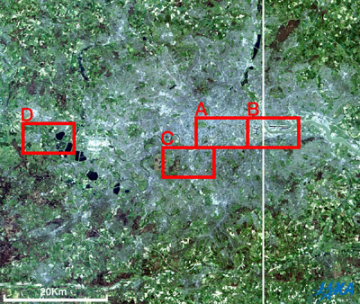
The Advanced Visible and Near-Infrared Radiometer (AVNIR) aboard JAXA's (former NASDA) Advanced Earth Observing Satellite "Midori" (ADEOS) captured London without fog. The whitish structural part at the center is the city area in London. The residential quarter is the light-brown area. Just outside that area is the rich green countryside. The Thames goes from west to east in London, appearing black on the west side of London, muddy and light-brown in the urban areas and olive on the east side. West of London, Heathrow International airport, one of five airports around London, can be identified by its facilities and runways that appear white. Some black looking reservoirs can be seen in the north and west of London. The white stripes that extend in all directions and surround London are roads. Britain is the birthplace of the railway system. Some railways, seen as brown stripes, radiate in all directions from the urban area in London (frames A and C). There are a lot of terminal stations in London as many railway companies constructed their railways connecting the rest of England with the capital. In frame A you can see the Thames, many bridges crossing over it at the center, and numerous buildings in the City north of the river. You can easily find some of the World Cultural Heritage sites: the Tower of London on the right, Westminster Palace (The Houses of Parliament), Westminster Abbey and St. Margaret's Church on the left. Also, on the north side of the Thames, you find St. Paul's Cathedral, the British Museum, and King's Cross Station that appears in "Harry Potter". That is the terminal for trains going north, such as to Edinburgh. You can also find Buckingham Palace, which is the official residence of the British Royal family, with its rich green parks on the left. Waterloo Station is seen south of the Thames in the center. The high-speed Eurostar train arrives and departs here, connecting with the Gare du Nord Station in Paris and the Midi Station in Brussels in a little less than three hours, traveling through the submarine tunnel under the Dover Strait, the narrowest part of the English Channel. Maritime Greenwich, one of the World Cultural Heritage sites, is in a hairpin bend of the Thames on the south bank in frame B. At the International Meridian Conference, held in Washington DC, USA, in 1884, it was established that the meridian which passes through the Royal Observatory in Greenwich be adopted as the Prime Meridian (the meridian of longitude 0 degrees) . At that time, a universal time system was needed due to the increasing international exchange brought on by the Industrial Revolution, and it was inconvenient to have different time systems in each country. The places that look black on the upper right and left are the docks of closed shipyards, which means that they are filled with clear water. These regions were redeveloped and reborn as London City Airport (you can see the runway between the docks if you look carefully) and a new business district. Wimbledon Park is seen at the center of frame C, and you can see Center Court where the Wimbledon Championships are held from the end of June to the beginning of July each year. The orderly form of the residential area, a marvel of neatness, is seen on the right, and Wimbledon common, including the golf courses and forests, is seen on the left. Windsor Castle, the world's largest castle that is still used as a residence, can be seen at the center of frame D, and Eton College, which was attended by many British Prime Ministers, is on the upper part of the frame. A large reservoir is seen on the right and the town of Windsor on the lower left. The other parts are grasslands or farmlands, and the pastoral landscape appears extensive there. Finally, you can see the narrow Thames river meandering in the center. This river runs for 340 km, and has been a central part of British history for over 2,000 years.
Related Sites: Appendices: Accurate time: Although the length of one second was previously defined by celestial observation, since 1967 it has been measured by an atomic clock using the transition frequency of the atom of cesium. The Bureau International des Poids et Mesures (BIPM) in Paris decides the International Atomic Time (TAI) that is the Universal Time. Cesium atomic clocks are also aboard the GPS satellites that provide data for car navigation systems, and supply very accurate time. The National Institute of Information and Communications Technology (NICT) operates JJY, the standard frequency and time signal, and supplies the Japan Standard Time (JST) based on the Coordinated Universal Time (UTC), so if you use a radio watch you can have the most accurate time. Fog capital: Houses of 19th century London used gas lamps and coal gas for lighting, and coal for heating. This created a lot of smoke and soot, and the air was very polluted. As a result, fog was generated easily, and at times it became so bad that you could not see one meter in front of you. Eurotunnel: The Eurotunnel connecting Britain with France, crossing under the English Channel, is 50.49 km long and the second longest railway submarine tunnel in the world. The longest is the Seikan Tunnel connecting Hokkaido with Honshu in Japan, crossing under the Tsugaru Straits, and is 53.85 km long. The level of Japanese technology for digging tunnels is so advanced that the same technology was used for digging the Eurotunnel. The Eurotunnel was constructed by tunneling in the Cretaceous stratum, although there was some ascending and descending, because the Cretaceous stratum is a steady stratum without dislocation. In 1994, the high-speed train, the Eurostar, traveled up to London after the opening of the Eurotunnel. Industrial Revolution spawned Geology: Britain became the world leader in the Industrial Revolution starting in the 18th century. Accordingly, coal began to be used for steam engines and heating, and geological surveys were carried out to search for the coal layers, leading to the development of geology. The coal layer (coal stratum) is distributed in Scotland, the north and the center of England, and Wales and based on the layers of strata above and below the coal layer, the geological periods such as the Cambrian ("Cambria" is old common name of Wales), the Devonian (which was named after the county of Devon in southern Britain), and the Carboniferous were defined. Moreover, the Cretaceous, which was the last geological period when the dinosaur was still alive, was defined based on the white limestone layer seen in the cliffs on both sides of the Dover Strait at Dover and Calais. |
|||||||||||||||||||||||||||||